Odisha State Map.svg

ମୂଳ ଫାଇଲ ‎(SVG ଫାଇଲ, ସାଧାରଣ ମାପ ୨,୧୮୪ × ୧,୭୬୯ ପିକ୍ସେଲ, ଫାଇଲ ଆକାର: ୧.୭୬ MB)
ସାରକଥା

ଶିରୋନାମ
Odisha locator map
Description
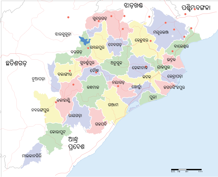
ଓଡ଼ିଆ: ଓଡ଼ିଆରେ ଓଡ଼ିଶାର ରେଖାଙ୍କିତ ମାନଚିତ୍ର ।
Odisha State Map.svg
ଏହି media fileଟି ଉଇକିପିଡ଼ିଆକୁ ଭଲପାଏ ଓଡ଼ିଆ ଦେଇ ଅପଲୋଡ଼ କରାଯାଇଅଛି ।

বাংলা | English | हिन्दी | italiano | македонски | മലയാളം | ଓଡ଼ିଆ | sicilianu | +/−
English: Locator map of the state of w:Odisha, India with district boundaries.
ତାରିଖ
ମୂଳାଧାର

ଆପଣା କାମ
International Borders: University of Texas map library - India Political map 2001
Disputed Borders: University of Texas map library - China-India Borders - Eastern Sector 1988 & Western Sector 1988 - Kashmir Region 2004 - Kashmir Maps.
State and District boundaries: Census of India - 2001 Census State Maps - Survey of India Maps.
Other sources: US Army Map Service, Survey of India Map Explorer, Columbia University

Map specific sources: http://commons.wikimedia.org/wiki/File:Orissa_State_map.svg.
Creator
ଅନୁମତି
(ଏହି ଫାଇଲକୁ ପୁଣି ବ୍ୟବହାର କରିବେ)
ମୁଁ, ଏହି କାମର ସତ୍ଵାଧିକାରୀ, ଏଠାରେ ତଳଲିଖିତ ଲାଇସେନ୍ସ ଅଧୀନରେ ଏହାକୁ ପ୍ରକାଶ କଲି:
w:en:Creative Commons
ଶ୍ରେୟ ସେଆର ଏଲାଇକ
ଏହି ଫାଇଲଟି କ୍ରିଏଟିଭ କମନ୍ସ ଅଧୀନରେ ଆଟ୍ରିବୁସନ ସେଆର-ଏଲାଇକ ୩.୦ ଅନପୋର୍ଟେଡ଼ ଲାଇସେନ୍ସରେ ପଞ୍ଜିକରଣ କରାଯାଇଅଛି ।
    ଆପଣ ଆରାମରେ:
    • ବାଣ୍ଟିପାରିବେ – କାମଟିକୁ ନକଲ କରିପାରିବେ, ବାଣ୍ଟିପାରିବେ ଓ ପ୍ରସାରଣ କରିପାରିବେ
    • ମିଶାଇପାରିବେ – କାମଟି ଅଭିଯୋଜନ କରିପାରିବେ
    ତଳଲିଖିତ ସର୍ତ୍ତାବଳୀ ଅଧୀନରେ:
    • ଶ୍ରେୟ – ଆପଣ ମନେ କରି ଏହି କାମର ଆବଶ୍ୟକୀୟ ଶ୍ରେୟ ମୂଳ ଗଢ଼ାଳି ବା ସ୍ୱତ୍ୱାଧୀକାରୀଙ୍କୁ ଦେବେ ଏବଂ ଦେଲାବେଳେ ଲାଇସେନ୍ସର ଲିଙ୍କ ଦେଇ କି କି ବଦଳ କଲେ ଉଲ୍ଲେଖ କରିବେ । ଏହା ଉପଯୁକ୍ତ ଢଙ୍ଗରେ କରିବେ କିନ୍ତୁ ଲାଇସେନ୍ସ ଦେଉଥିବା ବ୍ୟକ୍ତି ଆପଣଙ୍କ ପ୍ରଚାର କଲା ଭଳି କିଛି ଲେଖିବେ ନାହିଁ ।
    • ସେଆର ଏଲାଇକ – ଯଦି ଆପଣ ଏହି କାମଟିକୁ ବଦଳାଇବେ, ରୂପାନ୍ତରଣ କରିବେ ବା ଏହାକୁ ନେଇ କିଛି ଗଢ଼ିବେ ତେବେ ଆପଣ ଏହାକୁ ଏକା ବା ଅଲଗା ଲାଇସେନ୍ସ ଭିତରେ ରଖିପାରିବେ ।

Odisha State Map.svgThe frontiers depicted on the Indian maps in Wikipedia are from a neutral point of view and may differ from official government maps of India, Pakistan and China. Please consult local laws governing publication of maps before usage.
 Geotemporal data
Date depicted second half of 20 century21 century
Georeferencing Georeference the map in Wikimaps Warper If inappropriate please set warp_status = skip to hide.
 Archival data
ଟୀକା Part of WikiProject India Maps

ସତ୍ଵ

w:en:Creative Commons
ଶ୍ରେୟ ସେଆର ଏଲାଇକ
ଏହି ଫାଇଲଟି କ୍ରିଏଟିଭ କମନ୍ସ ଅଧୀନରେ ଆଟ୍ରିବୁସନ ସେଆର-ଏଲାଇକ ୩.୦ ଅନପୋର୍ଟେଡ଼ ଲାଇସେନ୍ସରେ ପଞ୍ଜିକରଣ କରାଯାଇଅଛି ।
    ଆପଣ ଆରାମରେ:
    • ବାଣ୍ଟିପାରିବେ – କାମଟିକୁ ନକଲ କରିପାରିବେ, ବାଣ୍ଟିପାରିବେ ଓ ପ୍ରସାରଣ କରିପାରିବେ
    • ମିଶାଇପାରିବେ – କାମଟି ଅଭିଯୋଜନ କରିପାରିବେ
    ତଳଲିଖିତ ସର୍ତ୍ତାବଳୀ ଅଧୀନରେ:
    • ଶ୍ରେୟ – ଆପଣ ମନେ କରି ଏହି କାମର ଆବଶ୍ୟକୀୟ ଶ୍ରେୟ ମୂଳ ଗଢ଼ାଳି ବା ସ୍ୱତ୍ୱାଧୀକାରୀଙ୍କୁ ଦେବେ ଏବଂ ଦେଲାବେଳେ ଲାଇସେନ୍ସର ଲିଙ୍କ ଦେଇ କି କି ବଦଳ କଲେ ଉଲ୍ଲେଖ କରିବେ । ଏହା ଉପଯୁକ୍ତ ଢଙ୍ଗରେ କରିବେ କିନ୍ତୁ ଲାଇସେନ୍ସ ଦେଉଥିବା ବ୍ୟକ୍ତି ଆପଣଙ୍କ ପ୍ରଚାର କଲା ଭଳି କିଛି ଲେଖିବେ ନାହିଁ ।
    • ସେଆର ଏଲାଇକ – ଯଦି ଆପଣ ଏହି କାମଟିକୁ ବଦଳାଇବେ, ରୂପାନ୍ତରଣ କରିବେ ବା ଏହାକୁ ନେଇ କିଛି ଗଢ଼ିବେ ତେବେ ଆପଣ ଏହାକୁ ଏକା ବା ଅଲଗା ଲାଇସେନ୍ସ ଭିତରେ ରଖିପାରିବେ ।

Odisha State Map.svg

ମୂଳ ଫାଇଲ ‎(SVG ଫାଇଲ, ସାଧାରଣ ମାପ ୨,୧୮୪ × ୧,୭୬୯ ପିକ୍ସେଲ, ଫାଇଲ ଆକାର: ୧.୭୬ MB)

Captions

Add a one-line explanation of what this file represents

Items portrayed in this file

ଦର୍ଶାଏ

copyright status<\/a>\u00a0\u0b07\u0b02\u0b30\u0b3e\u0b1c\u0b40<\/sup>"}},"text\/plain":{"or":{"":"copyright status"}}},"{\"value\":{\"entity-type\":\"item\",\"numeric-id\":50423863,\"id\":\"Q50423863\"},\"type\":\"wikibase-entityid\"}":{"text\/html":{"or":{"P6216":"copyrighted<\/a>\u00a0\u0b07\u0b02\u0b30\u0b3e\u0b1c\u0b40<\/sup>"}},"text\/plain":{"or":{"P6216":"copyrighted"}}}}" class="duhoc-or wbmi-entityview-statementsGroup wbmi-entityview-statementsGroup-P6216 oo-ui-layout oo-ui-panelLayout oo-ui-panelLayout-framed">

copyright status ଇଂରାଜୀ

copyrighted ଇଂରାଜୀ

copyright license<\/a>\u00a0\u0b07\u0b02\u0b30\u0b3e\u0b1c\u0b40<\/sup>"}},"text\/plain":{"or":{"":"copyright license"}}},"{\"value\":{\"entity-type\":\"item\",\"numeric-id\":14946043,\"id\":\"Q14946043\"},\"type\":\"wikibase-entityid\"}":{"text\/html":{"or":{"P275":"Creative Commons Attribution-ShareAlike 3.0 Unported<\/a>\u00a0\u0b07\u0b02\u0b30\u0b3e\u0b1c\u0b40<\/sup>"}},"text\/plain":{"or":{"P275":"Creative Commons Attribution-ShareAlike 3.0 Unported"}}}}" class="duhoc-or wbmi-entityview-statementsGroup wbmi-entityview-statementsGroup-P275 oo-ui-layout oo-ui-panelLayout oo-ui-panelLayout-framed">
source of file<\/a>\u00a0\u0b07\u0b02\u0b30\u0b3e\u0b1c\u0b40<\/sup>"}},"text\/plain":{"or":{"":"source of file"}}},"{\"value\":{\"entity-type\":\"item\",\"numeric-id\":66458942,\"id\":\"Q66458942\"},\"type\":\"wikibase-entityid\"}":{"text\/html":{"or":{"P7482":"original creation by uploader<\/a>\u00a0\u0b07\u0b02\u0b30\u0b3e\u0b1c\u0b40<\/sup>"}},"text\/plain":{"or":{"P7482":"original creation by uploader"}}}}" class="duhoc-or wbmi-entityview-statementsGroup wbmi-entityview-statementsGroup-P7482 oo-ui-layout oo-ui-panelLayout oo-ui-panelLayout-framed">

source of file ଇଂରାଜୀ

original creation by uploader ଇଂରାଜୀ

ଫାଇଲ ଇତିହାସ

ଏହା ଫାଇଲଟି ସେତେବେଳେ ଯେମିତି ଦିଶୁଥିଲା ତାହା ଦେଖିବା ପାଇଁ ତାରିଖ/ବେଳା ଉପରେ କ୍ଲିକ କରନ୍ତୁ

ତାରିଖ/ବେଳନଖ ଦେଖଣାଆକାରବ୍ୟବହାରକାରୀମତାମତ
ଏବେକାର୧୬:୫୨, ୧୮ ଅଗଷ୍ଟ ୨୦୧୧୧୬:୫୨, ୧୮ ଅଗଷ୍ଟ ୨୦୧୧ ପରିକା ସଙ୍କଳନର ନଖଦେଖଣା୨,୧୮୪ × ୧,୭୬୯ (୧.୭୬ MB)Psubhashish

ଜଗତ ଫାଇଲ ବ୍ୟବହାର

ମେଟାଡାଟା

Tags:

Odisha State map.svg

🔥 Trending searches on Wiki ଓଡ଼ିଆ:

୧୭ ଅପ୍ରେଲଉଇକିପିଡ଼ିଆସମ୍ବାଦ (ଖବରକାଗଜ)ନବକଳେବରବିଶ୍ୱତାପନମାତଙ୍ଗୀଲିଙ୍ଗରାଜ ମନ୍ଦିରଜଗନମୋହ‌ନ ଲାଲବିଜୟ ମିଶ୍ରକପିଳାସ ଶିବ ମନ୍ଦିରହିମାଳୟଯକ୍ଷ୍ମାଅମର ପ୍ରସାଦ ଶତପଥୀଗୌରୀଶଙ୍କର ରାୟପ୍ରଥମ ବିଶ୍ୱଯୁଦ୍ଧଶ୍ରୀ ଦେବ ରାମେଶ୍ଵର ମନ୍ଦିରଇସଲାମ ଧର୍ମକୁଞ୍ଜବିହାରୀ ଦାଶକାଜଲଡଙ୍ଗରିଆ କନ୍ଧ୧୯ ମାର୍ଚ୍ଚସପ୍ତମାତୃକା ମନ୍ଦିର, ଯାଜପୁରସୂର୍ଯ୍ୟୋଦୟଟାଇଫଏଡପ୍ରଦୀପ କୁମାର ପାଣିଗ୍ରାହୀନୂଆ ଦିଲ୍ଲୀଶବ୍ଦ (ଧ୍ୱନି)ଆଖଣ୍ଡଳମଣି ମନ୍ଦିରସଚ୍ଚିଦାନନ୍ଦ ରାଉତରାୟଚାଣକ୍ୟପାରାଦ୍ୱୀପଇତିହାସଚୈତନ୍ୟସୁଭାଷ ଚନ୍ଦ୍ର ବୋଷଖୋର୍ଦ୍ଧାଯୌନ ସମ୍ଭୋଗପଞ୍ଚକନ୍ୟାପିତ୍ତକୋଷକବୀରଲକ୍ଷ୍ମୀକାନ୍ତ ମହାପାତ୍ରଜାପାନଓଡ଼ିଆ ଭାଷା ଆନ୍ଦୋଳନଓଡ଼ିଶାର ଭୂଗୋଳଗୋପୀନାଥ ମହାନ୍ତି୧୯୯୯ ଓଡ଼ିଶା ମହାବାତ୍ୟାତାମିଲ ଭାଷାଜଗନ୍ନାଥ ପ୍ରସାଦ ଦାସକ୍ଷୀରବୈଶାଖଜ୍ଞାନପୀଠ ପୁରସ୍କାରଜିନା ସାମଲହୃଷୀକେଶ ପଣ୍ଡାବ୍ରଜନାଥ ବଡ଼ଜେନାମାୟାଧର ମାନସିଂହଟାଟା ମୋଟରସରାଧାମୋହନ ଗଡ଼ନାୟକହିନ୍ଦୁଓଡ଼ିଶା ସାହିତ୍ୟ ଏକାଡେମୀ ପୁରସ୍କାରଟାଇପରାଇଟରରାଜକିଶୋର ପଟ୍ଟନାୟକ୧୯୮୪ରତ୍ନାକର ଚଇନି🡆 More