Niger: Sovereign state in western Africa
Niger or the Niger (/niːˈʒɛər/ or /ˈnaɪdʒər/; French: ), officially the Republic of the Niger, is a country in western Africa.
The capital is Niamey, and the official language is French. It is surrounded by Algeria and Libya to the north, Chad to the east, Nigeria and Benin to the south, and Burkina Faso and Mali to the west. Niger is landlocked, meaning it has no coastline. Niger gets its name from the Niger River, whose name possibly comes from the Berber word "River of Rivers".
Republic of the Niger
| |
|---|---|
 Coat of arms | |
Motto:
| |
| Anthem: L'Honneur de la Patrie | |
.svg) Location of Niger (dark green) | |
| Capital and largest city | Niamey 13°32′N 2°05′E / 13.533°N 2.083°E |
| Official languages | French |
| National languages |
|
| Demonym(s) | Nigerien (/niːˈʒɛəriən/ |
| Government | Unitary semi-presidential republic under a military junta |
| Omar Tchiani | |
| Ali Lamine Zeine | |
| Legislature | National Assembly |
| Independence from France | |
• Republic proclaimed | 18 December 1958 |
• Declared | 3 August 1960 |
| Area | |
• Total | 1,267,000 km2 (489,000 sq mi) (21st) |
• Water (%) | 0.02 |
| Population | |
• 2020 estimate | 23,196,002 (57th) |
• 2012 census | 17,138,707 |
• Density | 12.1/km2 (31.3/sq mi) |
| GDP (PPP) | 2018 estimate |
• Total | $23.475 billion (140th) |
• Per capita | $1,213 (183rd) |
| GDP (nominal) | 2018 estimate |
• Total | $9.869 billion (136th) |
• Per capita | $510 (179th) |
| Gini (2014) | medium · 70th |
| HDI (2019) | low · 189th |
| Currency | West African CFA franc (XOF) |
| Time zone | UTC+1 (WAT) |
| Driving side | right |
| Calling code | +227 |
| ISO 3166 code | NE |
| Internet TLD | .ne |
| |

The Mali Empire and the Songhai Empire both had land in what is now Niger. Later France controlled the land that is now Niger. Niger has a population, or the number of people living in an area, of 15,306,252 and an area of 1,267,000 square kilometres. Much of Niger is desert.
After a military coup in 2010, Niger is now a democratic, multi-party state. Most of the people live in rural areas, and have little access to advanced education.
Niger is one of the poorest countries in the world with a lack of contraception. 41.4% live in poverty. Hunger plagues the country.
Niger’s main exports are uranium ore, livestock, cowpeas and onions. Millet and sorghum are grown in the south, as well as cassava and sugarcane. Rice is grown in the Niger River valley. Peanuts are the most important cash crop. Other important crops are cotton and pulses.
Niger is home to the critically endangered addax antelope. West African giraffes are the only giraffes in West Africa that exist in Niger.
Geography
Niger is on the border between the Sahara and Sub-Saharan regions. Niger's area is 1,267,000 square kilometres (489,191 sq mi) of which 300 square kilometres (116 sq mi) is water. It is the world's twenty-second largest country. Niger borders seven countries. The longest border is with Nigeria to the south.
The lowest point is the Niger River, with an elevation of 200 metres (656 ft). The highest point is Mont Idoukal-n-Taghès in the Aïr Mountains at 2,022 m (6,634 ft).
Regions
- Northern Niger: Agadez Region
- South-Central Niger: Maradi Region, Tahoua Region, Zinder Region
- South-Eastern Niger: Diffa Region, Zinder Region
- South-Western Niger: Tillabéri Region, Dosso Region, Niamey, Tahoua Region
Zinder Region and Tahoua Region are intermediates between Central Niger.
Cities
This table shows cities with a population over 10,000, according to 2001 census.
Climate
Niger's subtropical climate is mainly very hot and dry. Much of it is covered by desert. In the extreme south there is a tropical climate on the edges of the Niger River basin. The land is mostly desert plains and sand dunes. There is flat to rolling savanna in the south and hills in the north.
Wildlife
-
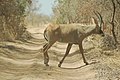 Gazelle
 -
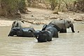 Elephants
 -
 Violet turaco
 -
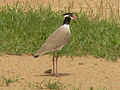 Black-headed lapwing
 -
 Blue-naped mousebird


Demographics
There are several ethnic groups in Niger:
Education
The literacy rate (the amount of the adult population who can read or write) of Niger is among the lowest in the world. In 2005 it was estimated to be only 28.7% (42.9% male and 15.1% female). Primary education in Niger is required for six years. The primary school enrollment and attendance rates are low, particularly for girls. Children are often made to work rather than attend school. This is particularly true during planting or harvest periods.
Related pages
Notes
References
Other websites
- Niger - CIA world factbook Archived 2020-04-24 at the Wayback Machine
 This short article about a place or feature can be made longer. You can help Wikipedia by adding to it.
This article uses material from the Wikipedia Simple English article Niger, which is released under the Creative Commons Attribution-ShareAlike 3.0 license ("CC BY-SA 3.0"); additional terms may apply (view authors). Content is available under CC BY-SA 4.0 unless otherwise noted. Images, videos and audio are available under their respective licenses.
®Wikipedia is a registered trademark of the Wiki Foundation, Inc. Wiki Simple English (DUHOCTRUNGQUOC.VN) is an independent company and has no affiliation with Wiki Foundation.