පාළු දූපත්
පාළු දූපත් එසේත් නැත්නම් ජනශූන්ය දූපත් (ඉංග්රීසි: desert island, deserted island, uninhabited island) යනු ස්ථිර ලෙස ම පිහිටි මානව ජනාවාස රහිත දූපත් වේ.

තෝරාගත් ජනශූන්ය දූපත් ලැයිස්තුව

- Amatignak Island, southernmost point of Alaska, US
- Appat Island, Greenland
- ʻAta, the southernmost island of the Kingdom of Tonga
- Auckland Islands in the South Pacific, which are part of New Zealand
- Astola Island, Pakistan
- A majority of the Barra Isles, the Outer Hebrides, Scotland. The most famous of these is Barra Head.
- Blasket Islands in County Kerry, Ireland
- Ball's Pyramid, a tall volcanic mountain located close to Lord Howe Island in the South Pacific
- Binlang Islet, Lieyu Township (Lesser Kinmen), Kinmen County (Quemoy), Taiwan (Republic of China)
- Most of the Canadian Arctic Archipelago
- Caquorobert, Guernsey
- Clipperton Island, a Pacific island of France
- Coral Sea Islands off the northeastern coast of Australia
- De Long Islands in the Arctic Ocean, part of Russia
- Desertas Islands, Portugal
- Devon Island, the largest uninhabited island in the world at 55,247 km2
- Gotska Sandön, Sweden
- Heard Island and McDonald Islands, Australia
- Many islands within the waters of Hong Kong
- Ilha da Queimada Grande "Snake Island", Brazil
- Isle Royale in Lake Superior
- Keros and other small islands off the coast of Greece
- Žut and other islands off the coast of Croatia
- Kermadec Islands, part of New Zealand
- Korzhin Island in Lake Balkhash
- Klein Curaçao, Curaçao
- Lampione, Sicily
- Lítla Dímun, Faroe Islands
- Luci Island in Xiuyu District, Putian, Fujian, China (PRC)
- Ogurchinsky Island in the Caspian Sea
- Rat Islands, a volcanic island in the Aleutian Islands
- Santa Luzia, Cape Verde
- Savage Islands, Portugal
- Shag Rocks (South Georgia)
- Surtsey, a volcanic island located south of Iceland
- Tetepare Island, the largest uninhabited island in the South Pacific
- Topo Islet, Azores, Portugal
- Most of the United States Minor Outlying Islands, such as Johnston Atoll, Wake Island and Midway Atoll. Palmyra Atoll has no permanent residents but it has private landholdings that are continuously occupied by temporary residents.
-
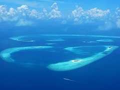 Plane view of Baa Atoll, Maldives
 -
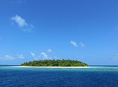 Desert island from Baa Atoll
 -
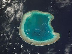 Bassas da India, Indian Ocean
 -
 Chissioua Bandrélé, Mayotte
 -
 Mtsanga Tsoholé, Mayotte
 -
 Gombé Ndroumé, Mayotte


විශාලතම ජනශූන්ය දූපත් ලැයිස්තුව
| Rank | Area Rank | Island | Area (km2) | Area (sq mi) | Country/Countries | Coordinates |
|---|---|---|---|---|---|---|
| 1 | 27 | Devon Island (Tallurutit) | 55,247 | 21,331 | Canada (Nunavut) | 75°08′N 87°51′W |
| 2 | 28 | Alexander Island (Isla Alejandro I) | 49,070 | 18,950 | None (Antarctic territorial claims by Argentina, Chile, and the United Kingdom) | 71°00′S 70°00′W |
| 3 | 30 | Severny Island (Severnyy Ostrov) | 48,904 | 18,882 | Russia (Arkhangelsk Oblast) | 75°30′N 60°00′E |
| 4 | 31 | Berkner Island (Isla Berkner) | 44,000 | 17,000 | None (Antarctic territorial claims by Argentina and the United Kingdom) | 79°30′S 47°30′W |
| 5 | 32 | Axel Heiberg Island (Umingmat Nunaat) | 43,178 | 16,671 | Canada (Nunavut) | 79°26′N 90°46′W |
| 6 | 33 | Melville Island (Ilulliq) | 42,149 | 16,274 | Canada (Northwest Territories and Nunavut) | 75°30′N 111°30′W |
| 7 | 40 | Prince of Wales Island (Kinngailak) | 33,339 | 12,872 | Canada (Nunavut) | 72°40′N 99°00′W |
| 8 | 46 | Somerset Island (Kuuganajuk) | 24,786 | 9,570 | Canada (Nunavut) | 73°15′N 93°30′W |
| 9 | 47 | Kotelny Island (Olgujdaah Aryy) | 24,000 | 9,300 | Russia (Sakha Republic) | 75°20′N 141°00′E |
| 10 | 54 | Bathurst Island | 16,042 | 6,194 | Canada (Nunavut) | 75°46′N 99°47′W |
| 11 | 55 | Prince Patrick Island | 15,848 | 6,119 | Canada (Northwest Territories) | 76°45′N 119°30′W |
| 12 | 56 | Thurston Island | 15,700 | 6,100 | None | 72°6′S 99°0′W |
| 13 | 57 | Nordaustlandet | 14,467 | 5,586 | Norway (Svalbard) | 79°48′N 22°24′E |
| 14 | 59 | October Revolution Island | 14,170 | 5,470 | Russia (Krasnoyarsk Krai) | 79°30′N 97°00′E |
| 15 | 68 | Ellef Ringnes Island | 11,295 | 4,361 | Canada (Nunavut) | 78°30′N 102°15′W |
| 16 | 69 | Bolshevik Island | 11,270 | 4,350 | Russia (Krasnoyarsk Krai) | 78°63'N 102.48°E |
| 17 | 71 | Bylot Island | 11,067 | 4,273 | Canada (Nunavut) | 73°16′N 78°30′W |
| 18 | 77 | Prince Charles Island | 9,521 | 3,676 | Canada (Nunavut) | 67°47′N 76°12′W |
| 19 | 82 | Komsomolets Island | 9,006 | 3,477 | Russia (Krasnoyarsk Krai) | 80°29′N 94°59′E |
| 20 | 85 | Carney Island | 8,500 | 3,300 | None | 73°57′S 121°00′W |
| 21 | 107 | Coats Island | 5,498 | 2,123 | Canada (Nunavut) | 62°35′N 82°45′W' |
| 22 | 111 | Amund Ringnes Island | 5,255 | 2,029 | Canada (Nunavut) | 78°20′N 96°25′W |
Most of the largest uninhabited islands are many kilometers/miles inside the Arctic or Antarctic circles, indicating that the reason for their desertedness is the freezing climate.
ආශ්රිත


- List of uninhabited regions
- ජනගහනය අනුව දූපත් ලැයිස්තුව
- Bonin Islands, whose name derives from the Japanese for 'desert island'
- Shipwreck, Marooning, Exile, & Castaway
- Castaway depot
- Desert Island Discs
මූලාශ්ර
භාහිර සබැඳි
This article uses material from the Wikipedia සිංහල article පාළු දූපත්, which is released under the Creative Commons Attribution-ShareAlike 3.0 license ("CC BY-SA 3.0"); additional terms may apply (view authors). අන්ලෙසකින් සඳහන්කර නැති සෑම විටෙකම අන්තර්ගතය CC BY-SA 4.0 යටතේ ඇත. Images, videos and audio are available under their respective licenses.
®Wikipedia is a registered trademark of the Wiki Foundation, Inc. Wiki සිංහල (DUHOCTRUNGQUOC.VN) is an independent company and has no affiliation with Wiki Foundation.