Espírito Santo: State in the Southeast Region of Brazil
Espírito Santo is one of the states of southeastern Brazil.
It is often referred to as "ES". The capital of ES is Vitória and its largest city is Vila Velha. Those who are born in the state are known as "Capixabas", but the more correct word is "Espiritossantenses". The name means "holy spirit" after the Holy Ghost of Christianity.
State of Espírito Santo (English: Holy Spirit) | |
|---|---|
| Motto(s): Trabalha e Confia (Portuguese) "Works and Trusts" | |
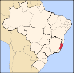
 Location of State of Espírito Santo in Brazil | |
| Coordinates: 20°19′08″S 40°20′16″W / 20.31889°S 40.33778°W | |
| Country | |
| Capital | Vitória |
| Government | |
| • Governor | Renato Casagrande |
| • Vice Governor | Givaldo Vieira |
| Area | |
| • Total | 46,077.519 km2 (17,790.630 sq mi) |
| • Rank | 23rd |
| Population (2012) | |
| • Total | 3,578,067 |
| • Rank | 15th |
| • Density | 78/km2 (200/sq mi) |
| • Rank | 7th |
| Demonym | capixaba or espiritossantense |
| GDP | |
| • Year | 2006 estimate |
| • Total | R$ 52,782,000,000 (11th) |
| • Per capita | R$ 15,236 (5th) |
| HDI | |
| • Year | 2005 |
| • Category | 0.802 – high (6th) |
| Time zone | UTC-03:00 (BRT) |
| • Summer (DST) | UTC-02:00 (BRST) |
| Postal Code | 29000-000 to 29990-000 |
| ISO 3166 code | BR-ES |
| Website | es.gov.br |
Location
This Brazilian state is in the southeastern subdivision of Brazil, which also contains the states of São Paulo, Minas Gerais and Rio de Janeiro. It is bordered by the Atlantic Ocean (east), the state of Bahia (north), the state of Minas Gerais (north and west), and the state of Rio de Janeiro (south). Espírito Santo's other main cities are Cachoeiro de Itapemirim, Colatina, Linhares, São Mateus and Aracruz.
Geography
At 46,180 km2 (17,830.2 sq mi), it is about the size of Estonia. The state has many different types of habitats, for example coastal planes, lakes, mountain forest and mangroves.
The islands of Trindade and Martim Vaz, 715 km (444.3 mi) east of Vitória in the Southern Atlantic Ocean, are also a part of Espirito Santo state.
Notable people
- José Paulino Gomes, supercentenarian
References
| States of Brazil |  |
|---|---|
| Acre | Alagoas | Amapá | Amazonas | Bahia | Ceará | Espírito Santo | Goiás | Maranhão | Mato Grosso | Mato Grosso do Sul | Minas Gerais | Pará | Paraíba | Paraná | Pernambuco | Piauí | Rio de Janeiro | Rio Grande do Norte | Rio Grande do Sul | Rondônia | Roraima | Santa Catarina | São Paulo | Sergipe | Tocantins | |
| Federal district: Distrito Federal | |
This article uses material from the Wikipedia Simple English article Espírito Santo, which is released under the Creative Commons Attribution-ShareAlike 3.0 license ("CC BY-SA 3.0"); additional terms may apply (view authors). Content is available under CC BY-SA 4.0 unless otherwise noted. Images, videos and audio are available under their respective licenses.
®Wikipedia is a registered trademark of the Wiki Foundation, Inc. Wiki Simple English (DUHOCTRUNGQUOC.VN) is an independent company and has no affiliation with Wiki Foundation.

