paktopo De.jpg
Original file (1,187 × 1,102 pixel, file ke size: 1.28 MB, MIME type: image/jpeg)
Ii preview ke size: 646 × 600 pixels Duusra resolutions: 259 × 240 pixels | 517 × 480 pixels | 827 × 768 pixels | 1,187 × 1,102 pixels.
Ii file Wiki Commons se aais hai aur duusra projects me bhi kaam me lawa jaae sake hai. Iske baare me aur jaankari file description page ke niche dekhawa jaae hai.
It's not actually seen like this from space. This is just a graphical representation of how it would be seen from space using graphical representations of how it would be seen from space.
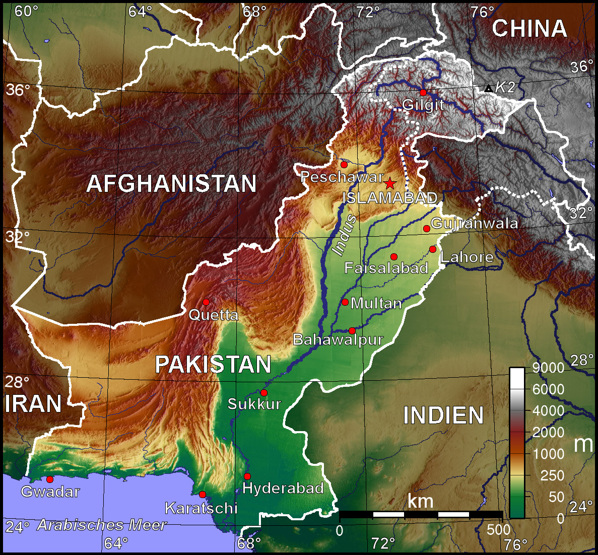
| Baare me | Topografische Karte Pakistans (deutschsprachige Version) |
| Taarik | |
| Source | Selbst erstellt mit Generic Mapping Tool |
| Likhe waala | BishkekRocks |
| Adhikaar (Ii file ke fir se kaam me laawa jaae hai) | Unter GNU-FDL veröffentlicht |
| Other versions | Other language versions available upon request |
The map has been created with the Generic Mapping Tools: https://www.generic-mapping-tools.org/ using one or more of these public-domain datasets for the relief:
|
 | Ijaajat dewa jaae hae ii document ke copy, distribute aur kare ke,under the terms of the GNU Free Documentation License, Version 1.2 or any later version published by the Free Software Foundation; with no Invariant Sections, no Front-Cover Texts, and no Back-Cover Texts. A copy of the license is included in the section entitled GNU Free Documentation License. |
| ii file ke Creative Commons Attribution-Share Alike 3.0 Unported license ke niche licence karaa gais hai. | ||
| ||
| This licensing tag was added to this file as part of the GFDL licensing update. |
paktopo De.jpg
Original file (1,187 × 1,102 pixel, file ke size: 1.28 MB, MIME type: image/jpeg)
File ke itihaas
File ke dekhe khatir, jaise uu time dekhe me lagat rahaa, date/time pe click karo.
| Din/Time | Chhota chapa | Lambai aur chaurai | Sadasya | Tiprrin | |
|---|---|---|---|---|---|
| abhi waala | 16:38, 11 Actobar 2006 | | 1,187 × 1,102 (1.28 MB) | Jungpionier | besser so |
| 15:47, 11 Actobar 2006 |  | 1,187 × 1,102 (307 KB) | Jungpionier | ein winziges kleines bisschen nachbearbeitet (rote Punkte außerhalb der Stadtmarkierungspunkte entfernt) | |
| 13:20, 11 Actobar 2006 |  | 1,187 × 1,102 (684 KB) | BishkekRocks | {{Information |Description=Topografische Karte Pakistans (deutschsprachige Version) |Source=Selbst erstellt mit Generic Mapping Tool |Date=11. Oktober 2006 |Author=BishkekRocks |Permission=Unter GNU-FDL veröffentlicht }} {{GMT}} [[C |
File ke kaise kaam me lawa gais hae
Niche ke panna kaam me laae hai ii file ke:
Global file usage
Ii aur duusra wiki ii file ke use kare hai:
- ace.wikipedia.org pe upyog
- azb.wikipedia.org pe upyog
- az.wikipedia.org pe upyog
- be.wikipedia.org pe upyog
- bg.wikipedia.org pe upyog
- bs.wikipedia.org pe upyog
- ca.wikipedia.org pe upyog
- de.wikipedia.org pe upyog
- diq.wikipedia.org pe upyog
- en.wikipedia.org pe upyog
- es.wikipedia.org pe upyog
- fiu-vro.wikipedia.org pe upyog
- frr.wikipedia.org pe upyog
- fr.wikipedia.org pe upyog
- hr.wikipedia.org pe upyog
- incubator.wikimedia.org pe upyog
- it.wikipedia.org pe upyog
- kk.wikipedia.org pe upyog
- lv.wikipedia.org pe upyog
- pl.wikipedia.org pe upyog
- pnb.wikipedia.org pe upyog
- sd.wikipedia.org pe upyog
- sh.wikipedia.org pe upyog
- tr.wikipedia.org pe upyog
- uk.wikipedia.org pe upyog
- ur.wikipedia.org pe upyog