Saragossa Erla: Gemeinde in Spanien
Erla ist eine spanische Gemeinde (Municipio) mit 360 Einwohnern (Stand: 1. Januar 2022) in der Comarca Cinco Villas in der Provinz Saragossa.
| Gemeinde Erla | |||
|---|---|---|---|
 | |||
| Wappen | Karte von Spanien | ||
 |
| ||
| Basisdaten | |||
| Land: | |||
| Autonome Gemeinschaft: | |||
| Provinz: | Saragossa | ||
| Comarca: | Cinco Villas | ||
| Gerichtsbezirk: | Ejea de los Caballeros | ||
| Koordinaten: | , 0° 57′ W42° 7′ N, 0° 57′ W | ||
| Höhe: | 425 msnm | ||
| Fläche: | 18,96 km² | ||
| Einwohner: | 360 (1. Jan. 2022) | ||
| Bevölkerungsdichte: | 19 Einw./km² | ||
| Postleitzahl(en): | 50611 | ||
| Gemeindenummer (INE): | 50100 | ||
| Verwaltung | |||
| Bürgermeister: | José Manuel Angoy | ||
| Lage des Ortes | |||
Karte anzeigen  | |||

Lage
Erla liegt am Río Arba de Biel etwa 50 Kilometer nordnordwestlich von Saragossa und grenzt im Westen an Ejea de los Caballeros und in den anderen drei Himmelsrichtungen an Luna.
Sehenswürdigkeiten
- Marienkirche (Iglesia de Santa María la Mayor)
- Einsiedelei am Monte de la Corona
- Torre del Señorío
- Castillo de Paúles
- Castillo de Santia
- Castillo de los Luna
-
 Marienkirche
 -
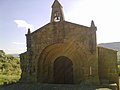 Einsiedelei


Söhne und Töchter der Stadt
- Antonio Aramburo (1840–1912), spanischer Tenor
- Eduardo Bandrés (* 1957), Professor für angewandte Wirtschaftswissenschaften an der Universität Saragossa, Politiker und ehemaliger Präsident von Real Saragossa
Weblinks
Einzelnachweise
This article uses material from the Wikipedia Deutsch article Erla (Saragossa), which is released under the Creative Commons Attribution-ShareAlike 3.0 license ("CC BY-SA 3.0"); additional terms may apply (view authors). Abrufstatistik · Autoren Der Inhalt ist verfügbar unter CC BY-SA 4.0, sofern nicht anders angegeben. Images, videos and audio are available under their respective licenses.
®Wikipedia is a registered trademark of the Wiki Foundation, Inc. Wiki Deutsch (DUHOCTRUNGQUOC.VN) is an independent company and has no affiliation with Wiki Foundation.