壺神山
壺神山(つぼがみやま)は、愛媛県大洲市と伊予市にまたがる出石山地に属する標高970.8mの山である。
| 壺神山 | |
|---|---|
 | |
| 標高 | 970.8 m |
| 所在地 | 愛媛県大洲市・伊予市 |
| 位置 | 北緯33度36分20.51秒 東経132度33分16.14秒 / 北緯33.6056972度 東経132.5544833度 |
| 山系 | 四国山地 |
 | |
この記事のほとんどまたは全てが唯一の出典にのみ基づいています。(2020年3月) |
北西は瀬戸内海に山裾を落とし、南西は肱川が流れる。この地方では一番高い山である。壺神様という天水の神を祀る地域信仰の山であり、山頂近くに壺神神社がある。
山頂直下に電波塔があるので車道が山頂近くまで来ており、15分足らずで頂上に至る。しかし頂上は雑木林の中にあり、展望は利かない。
ギャラリー
-
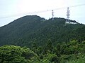 山頂近く
山頂近く -
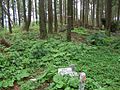 頂上
頂上 -
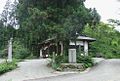 壺神神社
壺神神社


注釈・出典
関連項目
This article uses material from the Wikipedia 日本語 article 壺神山, which is released under the Creative Commons Attribution-ShareAlike 3.0 license ("CC BY-SA 3.0"); additional terms may apply (view authors). コンテンツは、特に記載されていない限り、CC BY-SA 4.0のもとで利用可能です。 Images, videos and audio are available under their respective licenses.
®Wikipedia is a registered trademark of the Wiki Foundation, Inc. Wiki 日本語 (DUHOCTRUNGQUOC.VN) is an independent company and has no affiliation with Wiki Foundation.