North America From Low Orbiting Satellite Suomi Npp.jpg
پروندهٔ اصلی (۸٬۰۰۰ × ۸٬۰۰۰ پیکسل، اندازهٔ پرونده: ۱۶٫۴۳ مگابایت، نوع MIME پرونده: image/jpeg)

اندازهٔ این پیشنمایش: ۶۰۰ × ۶۰۰ پیکسل. کیفیتهای دیگر: ۲۴۰ × ۲۴۰ پیکسل | ۴۸۰ × ۴۸۰ پیکسل | ۷۶۸ × ۷۶۸ پیکسل | ۱٬۰۲۴ × ۱٬۰۲۴ پیکسل | ۲٬۰۴۸ × ۲٬۰۴۸ پیکسل | ۸٬۰۰۰ × ۸٬۰۰۰ پیکسل.
| Wiki فارسی | این پرونده در ویکیانبار موجود است. محتویات صفحهٔ توصیف آن در زیر نمایش داده میشود. |
| این یک نگاره برگزیده است، بدین معنی که اعضای جامعه آن را بهعنوان یکی از نگارههای خوب در ویکیپدیای فارسی شناختهاند. اگر شما نگارهای متفاوت با کیفیت مشابه دارید، مطمئن شوید که آن را با برچسب مجوز آزاد بارگذاری میکنید، به مقالهٔ مرتبط میافزایید و آن را نامزد میکنید. |
خلاصه
| هشدار | بعضی از مرورگرها با نمایش این تصویر با وضوح تصویر بالا مشکل دارند: این تصویر تعداد زیادی نقطه دارد و ممکن است به درستی در مرورگر شما بارگیری نشود یا باعث متوقف شدن مرورگر شما شود. |
|---|
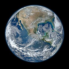
| توضیح | English: A view of most of North America taken from a low orbit of about 826 km altitude. The whole hemisphere is not visible owing to the low orbit, and the horizon is at a distance of about 3,300 km, while the radius of the planet is 6,371 km. The diameter seen from this height is about 125 degrees. An image of the Earth taken from the VIIRS instrument aboard NASA's Earth-observing research satellite, Suomi NPP. This composite image uses a number of swaths of the Earth's surface taken on 4 January 2012. The NPP satellite was renamed 'Suomi NPP' on 24 January 2012 to honour the late Verner E. Suomi of the University of Wisconsin. Suomi NPP carries five instruments on board. The biggest and most important instrument is The Visible/Infrared Imager Radiometer Suite or VIIRS. Español: Una vista de la mayor parte de América del Norte tomada desde una órbita baja. Esta vista resulta de una altura del satélite que está a unos 826 kilómetros por encima de la superficie de la Tierra. Debido a la órbita baja el hemisferio no es totalmente visible, y el horizonte se encuentra en una distancia de tan sólo aproximadamente 3300 km, mientras que el radio de nuestro planeta es 6371 kilómetros. El diámetro del horizonte visto desde esta altura es de aproximadamente 125 grados. | ||||
| تاریخ | |||||
| منبع | http://www.nasa.gov/multimedia/imagegallery/image_feature_2159.html; SEE Also => http://solarsystem.nasa.gov/multimedia/display.cfm?IM_ID=9643 AND http://solarsystem.nasa.gov/planets/profile.cfm?Object=Earth | ||||
| پدیدآور | NASA/NOAA/GSFC/Suomi NPP/VIIRS/Norman Kuring | ||||
| دیگر نسخهها |
|

.jpg)
|
This image was selected as picture of the day on Wiki Commons for 22 April 2014. It was captioned as follows: English: On Earth Day, a view of most of North America taken from a low orbit of about 826 km altitude aboard NASA's Earth-observing research satellite, Suomi NPP. Other languages: Bosanski: Fotografija načinjena na Dan planete Zemlje, pogled na veći dio Sjeverne Amerike iz niske orbite od oko 826 km iznad površine iz NASA-inog satelita za istraživanje Zemlje Suomi NPP. Čeština: Na dnešní den: Den Země, pohled na Severní Ameriku z nízké oběžné dráhy z výšky kolem 826 km, snímek z meteorologického satelitu Suomi NPP. English: On Earth Day, a view of most of North America taken from a low orbit of about 826 km altitude aboard NASA's Earth-observing research satellite, Suomi NPP. Italiano: L'America settentrionale fotografata in orbita bassa nella Giornata della Terra dal satellite di ricerca Suomi NPP. Magyar: A Föld napja: Észak-Amerika nagyobb részének képe, amely a NASA egyik alacsony pályán, mintegy 826 km magasságban keringő Föld-megfigyelő műholdjáról, a Suomi NPP-ről készült Nederlands: Op de Dag van de Aarde een blik op Noord-Amerika vanaf een lage baan op 826 kilometer hoogte vanuit de NASA-satelliet Suomi NPP. 中文: 世界地球日,美国宇航局的地球观测卫星在低轨道826公里处拍摄的北美洲大部分地区的照片。 |
اجازهنامه
| این پرونده در مالکیت عمومی قرار دارد چرا که توسط ناسا ایجاد شده است. سیاست حق تکثیر ناسا بیان میکند که «مواد ناسا با حق تکثیر محافظت نمیشوند، مگراینکه ذکر شده باشد». (Template:PD-USGov، صفحهٔ سیاست حق تکثیر ناسا یا سیاست جیپیال استفاده از تصاویر را ببینید.) | ||
 | هشدارها:
|
North America From Low Orbiting Satellite Suomi Npp.jpg
پروندهٔ اصلی (۸٬۰۰۰ × ۸٬۰۰۰ پیکسل، اندازهٔ پرونده: ۱۶٫۴۳ مگابایت، نوع MIME پرونده: image/jpeg)
تاریخچهٔ پرونده
روی تاریخ/زمانها کلیک کنید تا نسخهٔ مربوط به آن هنگام را ببینید.
| تاریخ/زمان | بندانگشتی | ابعاد | کاربر | توضیح | |
|---|---|---|---|---|---|
| کنونی | ۲۶ ژانویهٔ ۲۰۱۲، ساعت ۰۴:۰۳ | | ۸٬۰۰۰ در ۸٬۰۰۰ (۱۶٫۴۳ مگابایت) | Hellbus | {{Information |Description ={{en|1=A 'Blue Marble' image of the Earth taken from the VIIRS instrument aboard NASA's most recently launched Earth-observing satellite - Suomi NPP. This composite image uses a number of swaths of the Earth's surface taken |
کاربرد پرونده
صفحههای زیر از این تصویر استفاده میکنند:
کاربرد سراسری پرونده
ویکیهای دیگر زیر از این پرونده استفاده میکنند:
- کاربرد در af.wikipedia.org
- کاربرد در ar.wikipedia.org
- کاربرد در as.wikipedia.org
- کاربرد در az.wikiquote.org
- کاربرد در be-tarask.wikipedia.org
- کاربرد در bn.wikipedia.org
- کاربرد در crh.wikipedia.org
- کاربرد در cv.wikipedia.org
- کاربرد در de.wikipedia.org
- کاربرد در el.wikipedia.org
- کاربرد در en.wikipedia.org
- The Blue Marble
- Portal Energy
- Portal Energy/Energy topics
- User:Northamerica1000
- Portal Society/Featured article
- User talk:Semccraw
- User talk:Jesusserrano
- User talk:Bmbrooks
- User talk:Bhaluska
- User talk:Ependell
- User talk:Mmutterperl
- User talk:Kaylaek
- User talk:Tjohns17
- User talk:BellaBeast
- User talk:JessicaSG
- User talk:Laurenm2
- User talk:Jessgutman
- User talk:Lissyh1990
- User talk:Maxsasaki
- User talk:Aebarone
- User talk:Emackin
- User talk:Lmfye
- User talk:EauroraUA
- User talk:Jaallen1
- User talk:Dkunst
- User talk:Girg45
- User talk:Cindyy1
- User talk:Aglick
- Suomi NPP
- User:Cullen328/Welcome
- Wiki: Featured picture candidates/February-2012
- User talk:Sdmuszyn
- User talk:Allieglock
- User talk:Cpatel623
- User talk:Darrinbrink
نمایش استفادههای سراسری از این پرونده.