Fianarantsoa
Fianarantsoa is a city (commune urbaine) in south central Madagascar, and is the capital of Haute Matsiatra Region.
Fianarantsoa | |
|---|---|
 Upper town Fianarantsoa | |
 Coat of arms | |
 Fianarantsoa Location of Fianarantsoa in Madagascar | |
| Coordinates: 21°27′13″S 047°05′09″E / 21.45361°S 47.08583°E | |
| Country | |
| Province | Fianarantsoa |
| Region | Haute Matsiatra |
| District | Fianarantsoa |
| Founded | 1830 |
| Government | |
| • Mayor | Dr. RATSIMBAZAFY Sahondramalala Esther |
| Area | |
| • Total | 86.05 km2 (33.22 sq mi) |
| Elevation | 1,200 m (3,900 ft) |
| Population (2018) | |
| • Total | 191,776 |
| • Density | 2,200/km2 (5,800/sq mi) |
| Time zone | East Africa Time (GMT+3) |
| Postal code | 301 |
| Climate | Cwb |
| Website | http://fianara.cufianarantsoa.mg/ |
History
It was built in the early 19th century by the Merina as the administrative capital for the newly conquered Betsileo kingdoms.
Fianarantsoa means "Good education" in Malagasy. It is a cultural and intellectual center for the whole island. It is home to some of the oldest Protestant and Lutheran cathedrals on the island, the oldest theological seminary (also Lutheran), as well as the Roman Catholic Archdiocese of Fianarantsoa (seated in the Cathedral of the Holy Name of Jesus). The city of "good education" also boasts a university named after it and built in 1972. Fianarantsoa is considered to be the capital of wine in Madagascar, because of the presence of many wine industries in the city.
Geography
It is at an average altitude of 1,200 metres (3,900 ft), and has a population of 191,766.
The town is linked to the rest of the country by the National road 7, one of the main highways in Madagascar. The distance is 411 km to the capital Antananarivo, 192 km to Ihosy, 518 km to Tulear.
Ranomafana National Park is a nature park popular among tourists that lies 65 km to the northeast of Fianarantsoa. Another hot spot of tourism is the Isandra geolocical formations, roughly 30 km Northwest of Fianarantsoa. It can be accessed by the unpaved National road 42 from Fianarantsoa.
Rivers
Two rivers cross this town: the Mandranofotsy in the West, and the Tsiandanitra in the East. Both are affluents of the Matsiatra river.
Transport
The city is at the endpoint of the Fianarantsoa-Côte Est Railway to Manakara. There is also an airport. The city lies on the Route Nationale 7, which goes from the capital in Antananarivo to the coastal city of Toliara. Also the unpaved National road 42 takes its origins in Fianarantsoa.
Education

- Université de Fianarantsoa
- Faculté de médecine de Fianarantsoa
French international schools:
- Collège français René-Cassin
Sights
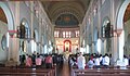
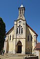
In the Upper Town (Haute Ville), Fianarantsoa's historical centre, where many brick houses were renovated in the original style, various churches on Rue du Rova street are worth a visit. The oldest church in Fianarantsoa is Eglise Antranobiriky dating from 1859. Fahazavana Church was built at the end of the 19th century in a neoromanesque style. Fiangonana Trinité Masombahoaka is a protestant neogothic church dating from 1885. The largest church, the cathedral Cathédrale du Saint-Nom-de-Jésus de Fianarantsoa, was built from 1871 to 1890.
The train station in the busy district Lower Town (Basse Ville) was inaugurated in 1935. In front of the train station, in the middle of Place de la gare square, a memorial dedicated to the victims of the Malagasy Uprising of 1947 was erected.
-
 Train station
 -
 Train station
 -
 Place de la Gare
 -
 Monument
 -
 Cathedral
 -
 Cathedral
 -
 Eglise Antranobiriky (1859)
 -
 Eglise Trinité Mahasombahoaka (1885)
 -
 Eglise Fahazavana
 -
 Rue du Rova


Sports
- Football: the ASF Fianarantsoa and Zanak'Ala FC are the local football teams.
Personalities
- Odon Razanakolona (born 1946), archbishop
- Pety Rakotoniaina (born 1962), politician
- Louis Cambrézy (1874), founder of the newspaper L'Écho du Sud based in Fianarantsoa.
Climate
Köppen-Geiger climate classification system classifies its climate as subtropical highland (Cwb).
| Climate data for Fianarantsoa (1991-2020) | |||||||||||||
|---|---|---|---|---|---|---|---|---|---|---|---|---|---|
| Month | Jan | Feb | Mar | Apr | May | Jun | Jul | Aug | Sep | Oct | Nov | Dec | Year |
| Record high °C (°F) | 33.4 (92.1) | 32.0 (89.6) | 31.9 (89.4) | 32.2 (90.0) | 29.9 (85.8) | 27.3 (81.1) | 28.5 (83.3) | 33.0 (91.4) | 32.5 (90.5) | 35.2 (95.4) | 34.8 (94.6) | 34.0 (93.2) | 35.2 (95.4) |
| Mean daily maximum °C (°F) | 26.8 (80.2) | 26.5 (79.7) | 26.4 (79.5) | 25.4 (77.7) | 23.5 (74.3) | 21.2 (70.2) | 20.3 (68.5) | 21.9 (71.4) | 24.1 (75.4) | 26.2 (79.2) | 27.6 (81.7) | 27.7 (81.9) | 24.8 (76.6) |
| Daily mean °C (°F) | 22.5 (72.5) | 22.3 (72.1) | 22.0 (71.6) | 20.7 (69.3) | 18.7 (65.7) | 16.4 (61.5) | 15.5 (59.9) | 16.4 (61.5) | 18.1 (64.6) | 20.4 (68.7) | 22.0 (71.6) | 22.7 (72.9) | 19.8 (67.7) |
| Mean daily minimum °C (°F) | 18.1 (64.6) | 18.0 (64.4) | 17.5 (63.5) | 16.0 (60.8) | 13.9 (57.0) | 11.6 (52.9) | 10.7 (51.3) | 11.0 (51.8) | 12.1 (53.8) | 14.6 (58.3) | 16.3 (61.3) | 17.6 (63.7) | 14.8 (58.6) |
| Record low °C (°F) | 12.2 (54.0) | 12.8 (55.0) | 11.8 (53.2) | 9.4 (48.9) | 5.6 (42.1) | 2.0 (35.6) | 2.9 (37.2) | 4.1 (39.4) | 5.0 (41.0) | 7.0 (44.6) | 10.0 (50.0) | 11.5 (52.7) | 2.0 (35.6) |
| Average precipitation mm (inches) | 259.3 (10.21) | 218.5 (8.60) | 139.6 (5.50) | 44.3 (1.74) | 25.3 (1.00) | 16.4 (0.65) | 24.3 (0.96) | 12.5 (0.49) | 9.9 (0.39) | 39.3 (1.55) | 117.5 (4.63) | 180.1 (7.09) | 1,087 (42.81) |
| Average precipitation days (≥ 1.0 mm) | 17.4 | 15.3 | 12.3 | 7.0 | 5.0 | 4.5 | 6.7 | 3.8 | 1.9 | 4.9 | 9.3 | 14.4 | 102.5 |
| Mean monthly sunshine hours | 191.1 | 171.0 | 175.4 | 184.8 | 186.0 | 165.9 | 163.5 | 191.1 | 220.5 | 230.4 | 208.0 | 190.1 | 2,277.8 |
| Source: NOAA | |||||||||||||
See also
References
External links
![]() Fianarantsoa travel guide from Wikivoyage
Fianarantsoa travel guide from Wikivoyage
This article uses material from the Wikipedia English article Fianarantsoa, which is released under the Creative Commons Attribution-ShareAlike 3.0 license ("CC BY-SA 3.0"); additional terms may apply (view authors). Content is available under CC BY-SA 4.0 unless otherwise noted. Images, videos and audio are available under their respective licenses.
®Wikipedia is a registered trademark of the Wiki Foundation, Inc. Wiki English (DUHOCTRUNGQUOC.VN) is an independent company and has no affiliation with Wiki Foundation.