Siquijor
Siquijor (/ˌsɪkiˈhɔːr/ SIK-ee-HOR, Tagalog: ), officially the Province of Siquijor (Cebuano: Lalawigan sa Siquijor; Tagalog: Lalawigan ng Siquijor), is an island province in the Philippines located in the Central Visayas region.
Its capital is the municipality of Siquijor, Siquijor. It is the third-smallest province in the Philippines in terms of population and land area. The province lies south of Cebu, southeast of Negros Oriental, southwest of Bohol, and north of Mindanao.
Siquijor | |
|---|---|
| Province of Siquijor | |
 Flag  Seal | |
.svg) Location in the Philippines | |
| Coordinates: 9°11′N 123°35′E / 9.18°N 123.58°E | |
| Country | Philippines |
| Region | Central Visayas |
| Founded | 17 September 1971 |
| Capital and largest municipality | Siquijor |
| Government | |
| • Type | Sangguniang Panlalawigan |
| • Governor | Jake Vincent S. Villa (NPC) |
| • Vice Governor | Mei Ling M. Quezon-Brown (NPC) |
| • Representative | Zaldy Villa (PDPLBN) |
| • Legislature | Siquijor Provincial Board |
| Area | |
| • Total | 337.49 km2 (130.31 sq mi) |
| • Rank | 79th out of 81 |
| Highest elevation (Mount Malabahoc) | 628 m (2,060 ft) |
| Population (2020 census) | |
| • Total | 103,395 |
| • Rank | 79th out of 81 |
| • Density | 310/km2 (790/sq mi) |
| • Rank | 29th out of 81 |
| • Voter (2019) | 76,225 |
| • Language | |
| Demonym | Siquijodnon |
| Divisions | |
| • Component cities | 0 |
| • Municipalities | |
| • Barangays | 134 |
| • Districts | Legislative district of Siquijor |
| Time zone | UTC+08:00 (PST) |
| ZIP code | 6225–6230 |
| IDD : area code | +63 (0)35 |
| ISO 3166 code | PH-SIG |
| Income class | 5th class |
| PSGC | 076100000 |
| Website | siquijorprovince |
.jpg)


.jpg)

During the Spanish colonial period of the Philippines, the Spaniards called Siquijor the Isla del Fuego (Island of Fire). Siquijor is commonly associated with mystic traditions that the island's growing tourism industry capitalizes on.
Etymology
One popular legend says the name "Siquijor" came from Datu Kihod. When the Spaniards arrived on the island, Kihod introduced himself, saying, "Si Kihod." Assuming this was the island's name, the Spaniards called it Sikihod before the name evolved to Siquijor.
Another legend says that a priest who visited the island said to the people in Bohol, "sequor," meaning "to follow the waves." The people misheard and assumed the island's name was Siquijor.
"Siquijor" may have also come from the native word quidjod, meaning "the tide is going out."
History
Early history
According to legend, Siquijor was formed from the sea by a storm and an earthquake in the Visayan region. In modern times, highland farmers have found giant seashells underneath their farm plots to support this legend.
Prior to colonization, Siquijor was home to the Kedatuan of Katugasan, named after the tugas, the molave trees which abounded the island. The native dwellers of the island used these trees to build posts (haligi) for their houses because of their strength and durability that could withstand strong typhoons and monsoons. Most of the patriarchs of the island used the tugas to make a wooden plow (tukod) to cultivate the rocky soil for farming using mainly male cattle (toro) to pull it through the sticky and hard rocky soil. However, before the discovery of using tugas as the foundations of their houses, the island natives dwelt in caves as shown by the pottery and old tools like stone grinder excavated from the three caves of Sam-ang.
During this time, the people of the kingdom were already in contact with Chinese traders, as seen through archaeological evidence including Chinese ceramics and other objects. The art of traditional healing and traditional witchcraft belief systems also developed within this period. During the arrival of the Spanish, the monarch of the island was Datu Kihod, as recorded in Legazpi's chronicles.
Spanish colonial era
The island was first sighted by the Spaniards in 1565 during Miguel López de Legazpi's expedition. The Spaniards called the island Isla del Fuego ("Island of Fire"), because the island gave off an eerie glow, from the great swarms of fireflies that lived in the numerous molave trees on the island. Esteban Rodríguez of the Legazpi expedition led the first Spaniards to discover the island. He was captain of a small party that left Legazpi's camp in Bohol to explore the nearby islands which are now called Pamilacan, Siquijor, and Negros.
The island, along with the rest of the archipelago, was subsequently annexed to the Spanish Empire. Founded in 1783 under the administration of secular clergymen, Siquijor became the first municipality as well as the first parish to be established on the island. Siquijor was, from the beginning, administered by the Diocese of Cebu. As for civil administration, Siquijor was under Bohol since the province had its own governor. The first Augustinian Recollect priest arrived in Siquijor in 1794. Several years later, a priest of the same order founded the parishes of Larena (initially called Can‑oan), Lazi (formerly Tigbawan), San Juan (Makalipay), and Maria (Cang‑meniao). With the exception of Enrique Villanueva, the other five municipalities were established as parishes in 1877. From 1854 to 1892, Siquijor was administered by the politico-military province of Bohol. Later in 1892, it was transferred to Negros Oriental and became its sub-province in 1901.
American invasion era
At the turn of the century, Spain ceded the Philippines to the United States of America with the Treaty of Paris that ended the Spanish–American War. Siquijor Island felt the presence of American rule when a unit of the American Cavalry Division came and stayed for some time. The American Military Governor in Manila appointed James Fugate, a scout with the California Volunteers of the U.S. Infantry, to oversee and implement the organization and development programs in Siquijor Island. Governor Fugate stayed for 16 years as lieutenant governor of Siquijor.
Japanese occupation era
While it was not at the center of military action, Siquijor was not spared by World War II. Imperial Japanese detachments occupied the island between 1942 and 1943, announcing their arrival on the island with heavy shelling. At the outbreak of the war, Siquijor was a sub-province of Negros Oriental, headed by Lieutenant Governor Nicolas Parami. Refusing to pledge allegiance to the Japanese forces, Parami was taken by Japanese soldiers from his residence at Poo, Lazi one evening and brought to the military headquarters in Larena. He was never heard from again. On November 10, 1942, Japanese warships started shelling Lazi from Cang‑abas Point. In Lazi, a garrison was established in the old Home Economics Building of the Central School. Filipino guerrillas engaged in sabotage and the interaction during this time caused havoc on the Japanese lives and properties.
During this period, Siquijor was briefly governed by Shunzo Suzuki, a Japanese civilian appointed by the Japanese forces until he was assassinated in October 1942 by the guerrilla forces led by Iluminado Jumawanin, of Caipilan, Siquijor. Mamor Fukuda took control of Siquijor from June 1943 until the Japanese forces abandoned the island when the liberation forces came in 1944. In 1943, the Japanese puppet government appointed Sebastian Monera of San Juan as Governor of Siquijor. His administration, however, was cut short when he was executed, presumably by Filipino guerrillas operating in the mountains of Siquijor.
On September 30, 1943, the United States submarine USS Bowfin (SS-287) delivered supplies to the people of Siquijor and evacuated people from the island. On February 21, 1945, the destroyer USS Renshaw (DD-499) was escorting a convoy of about 50 landing ships with 12 other escorts, when it was attacked by a Japanese midget submarine off the coast of Siquijor, which caused extensive damage to the ship and killed 19 of the crew.
In mid-1945, local Filipino soldiers and officers under the 7th, 75th, and 76th Infantry Division of the Philippine Commonwealth Army arrived, and alongside recognized guerrilla fighter groups, liberated Siquijor.
Philippine independence

For a time Siquijor was a subprovince of Negros Oriental, but it became an independent province on September 17, 1971, under Republic Act 6398. The move was supported by the people of Siquijor as they have a distinct culture from those of Negros Oriental, while Marcos used the movement as a means to secure support from the people of the island to pave martial law acceptance the following year. The capital, formerly Larena, was transferred to the municipality of Siquijor in 1972 by Proclamation No. 1075, under martial law.
Contemporary
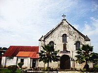
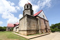
In 2006, the Lazi Church was added by the government as an extension to the Baroque Churches of the Philippines UNESCO World Heritage Site. The inscription of the church has been pending since.
Geography

| Siquijor Average annual temperature in Siquijor is 27·6°C Humidity 75–85% | ||||||||||||||||||||||||||||||||||||||||||||||||||||||||||||
|---|---|---|---|---|---|---|---|---|---|---|---|---|---|---|---|---|---|---|---|---|---|---|---|---|---|---|---|---|---|---|---|---|---|---|---|---|---|---|---|---|---|---|---|---|---|---|---|---|---|---|---|---|---|---|---|---|---|---|---|---|
| Climate chart (explanation) | ||||||||||||||||||||||||||||||||||||||||||||||||||||||||||||
| ||||||||||||||||||||||||||||||||||||||||||||||||||||||||||||
| ||||||||||||||||||||||||||||||||||||||||||||||||||||||||||||
Siquijor is an island province in Central Visayas. It is located in the Bohol Sea and lies south of Cebu across the Cebu Strait, southeast of Negros, southwest of Bohol, and north of Mindanao. Panglao Island, which is part of Bohol, has a similar soil composition found throughout Siquijor.
With a land area of 343.5 square kilometres (132.6 sq mi) and a coastline 102 kilometres (63 mi) long, Siquijor is the third-smallest province of the Philippines, both in terms of population and land area, after Camiguin and Batanes.
Topography
The island lies about 19 kilometres (12 mi) east of the nearest point on southern Negros, 25 kilometres (16 mi) southeast of Cebu, 30 kilometres (19 mi) southwest of Bohol, and 45 kilometres (28 mi) north of Zamboanga del Norte in Mindanao. It is predominantly hilly and in many places the hills reach the sea, producing precipitous cliffs. At the center, Mount Malabahoc (locally known as Mount Bandila‑an) reaches about 628 metres (2,060 ft) in elevation, the highest point on the island. Three marine terraces can be roughly traced around Tag‑ibo, San Juan, on the southwestern part of the island.
Siquijor is a coralline island, and fossils of the giant clam tridacna are often encountered in the plowed inland fields. On the hilltops, there are numerous shells of the molluscan species presently living in the seas around the island. Siquijor was probably formed quite recently, geologically speaking. The ocean depths between Siquijor, Bohol, and Mindanao are around 640 metres (350 fathoms; 2,100 feet).
Climate
Siquijor has two different climates, dominated by a tropical monsoon climate. All climate is within Coronas climate type IV, characterised by not very pronounced maximum rainfall with a short dry season from one to three months and a wet season of nine to ten months. The dry season starts in February and lasts through April sometimes extending to mid‑May.
Five of the municipalities have significant rainfall most months of the year, with a short dry season that has little effect. This location is classified as a tropical monsoon climate. The average annual temperature in Siquijor is 27.6 °C (81.7 °F), with variation throughout the year less than 2 degrees Celsius (3.6 deg F). The precipitation varies 165 millimetres (6 in) between the driest month and the wettest month, with the average rainfall 1,600 millimetres (63 in) or less.
The municipality of Lazi has a significant amount of rainfall during the year. This climate is classified as a tropical rainforest climate. In a year, the average rainfall is 1,655 millimetres (65 in).
Administrative division
Siquijor comprises six municipalities. Siquijor, Siquijor is the provincial capital.

| PSGC | City or Municipality | Population | ±% p.a. | Area | PD 2020 | |||||
|---|---|---|---|---|---|---|---|---|---|---|
| 2020 | 2010 | km2 | sq mi | /km2 | /sq mi | |||||
| 076101000 | Enrique Villanueva | 6.6% | 6,790 | 5,972 | ▴ | 1.29% | 28.60 | 11.04 | 240 | 610 |
| 076102000 | Larena | 14.0% | 14,454 | 12,931 | ▴ | 1.12% | 49.81 | 19.23 | 290 | 750 |
| 076103000 | Lazi | 21.7% | 22,488 | 20,024 | ▴ | 1.17% | 70.64 | 27.27 | 320 | 820 |
| 076104000 | Maria | 13.9% | 14,385 | 13,383 | ▴ | 0.72% | 53.37 | 20.61 | 270 | 700 |
| 076105000 | San Juan | 15.8% | 16,363 | 13,525 | ▴ | 1.92% | 44.37 | 17.13 | 370 | 960 |
| 076106000 | Siquijor † | 28.0% | 28,915 | 25,231 | ▴ | 1.37% | 90.70 | 35.02 | 320 | 830 |
| TOTAL | 103,395 | 91,066 | ▴ | 1.28% | 337.49 | 130.3 | 310 | 800 | ||
| † Provincial capital Municipality | ||||||||||
The lone legislative district of Siquijor is the representation of the province in various national legislatures. The current representative is Zaldy S. Villa of PDP-Laban.
Demographics

| Year | Pop. | ±% p.a. |
|---|---|---|
| 1903 | 50,156 | — |
| 1918 | 56,774 | +0.83% |
| 1939 | 59,507 | +0.22% |
| 1948 | 57,258 | −0.43% |
| 1960 | 59,555 | +0.33% |
| 1970 | 62,976 | +0.56% |
| 1975 | 69,077 | +1.87% |
| 1980 | 70,360 | +0.37% |
| 1990 | 73,932 | +0.50% |
| 1995 | 73,756 | −0.04% |
| 2000 | 81,598 | +2.19% |
| 2007 | 87,695 | +1.00% |
| 2010 | 91,066 | +1.38% |
| 2015 | 95,984 | +1.01% |
| 2020 | 103,395 | +1.47% |
| Source: Philippine Statistics Authority | ||
According to the 2020 census, Siquijor has a population of 103,395. The average annual growth rate between 2000 and 2015 was 1.09%, lower than the national growth rate of 1.87% for the same period.
Languages
The main language spoken in Siquijor is Cebuano, with Tagalog and English often used as second languages. Tagalog is understood and used as the national lingua franca, but it is rarely used in everyday conversation among locals.
Religion
95% of the island's residents belong to the Catholic Church, while the remainder belong to various other Christian churches. Despite the province's Catholic affinities, almost all of the residents continue to adhere to traditional practices that were used prior to the 15th century, albeit these practices have also adopted Christian belief systems as well. Due to the ingrained and indispensable traditional belief systems, the majority of residents have continued to possess a high respect for the natural environment which was revered by the ancestors of the people. Siquijor is known for its unique Philippine culture of blending Catholicism with traditional religious practices – a major part of its people's cultural heritage and identity.
Education
The literacy rate of 92.5% is one of the highest in the country. The Siquijor State College located in Larena is the only state college in the province.
Economy
Tourism
Siquijor's long-time reputation as a place of magic and sorcery both attracts and repulses visitors. Siquijor is also well known for its festivals that focus on healing rituals where incantations are sung while the old folks make potions out of herbs, roots, insects, and tree barks.
Among the many attractions include beaches, caves, and waterfalls. The most popular of them are the Cambugahay Falls and the centuries-old Balete tree, both located in Lazi. Mount Bandila-an, Siquijor's highest mountain, has a natural park and butterfly sanctuary, located at the center of the island in barangay Cantabon.
The coral reefs ringing the island offer some of the best diving in the Philippines for snorkelers and scuba divers. Dive courses are conducted by several dive operators on the island in versions of PADI, CMAS*, and NAUI.
Transportation
Siquijor has two public seaports: the Port of Siquijor and the Port of Larena. These seaports are capable of servicing cargo and passenger seacrafts daily. Destinations include Dumaguete in Negros Oriental, Tagbilaran in Bohol, Cebu City, and Plaridel in Misamis Occidental.
Siquijor also has an airfield, Siquijor Airport, located near Siquijor capable of handling smaller and mostly privately-owned airplanes. It does not serve commercial flights.
Gallery
-
 Cang‑Isok house in the town of Enrique Villanueva, a century-old house built on stilts that withstood ravages brought about by time and nature
 -
 Sandugan Beach, Larena
 -
 Cambugahay Falls, Lazi
 -
 Salagdoong Beach, Maria
 -
 St. Augustine of Hippo church, San Juan
 -
 Façade of Saint Francis of Assisi church, Siquijor
 -
-
 Sunset at the coastline of Siquijor


Notable personalities
- Julito Cortes, bishop of the Roman Catholic Diocese of Dumaguete
See also
Notes
References
Sources
External links
 Siquijor travel guide from Wikivoyage
- Official website
This article uses material from the Wikipedia English article Siquijor, which is released under the Creative Commons Attribution-ShareAlike 3.0 license ("CC BY-SA 3.0"); additional terms may apply (view authors). Content is available under CC BY-SA 4.0 unless otherwise noted. Images, videos and audio are available under their respective licenses.
®Wikipedia is a registered trademark of the Wiki Foundation, Inc. Wiki English (DUHOCTRUNGQUOC.VN) is an independent company and has no affiliation with Wiki Foundation.