Matanuska Glacier
Matanuska Glacier is a valley glacier in the US state of Alaska.
At 27 miles (43 km) long by 4 miles (6.4 km) wide, it is the largest glacier accessible by car in the United States. Its terminus feeds the Matanuska River. It lies near the Glenn Highway about 100 miles (160 km) northeast of Anchorage in Glacier View. The glacier flows about 1 foot (30 cm) per day. Due to ablation of the lower glacier, as of 2007[update], the location of the glacier terminus has changed little over the previous three decades.
| Matanuska Glacier | |
|---|---|
 Matanuska Glacier | |
 Matanuska Glacier | |
| Type | Mountain glacier |
| Location | Matanuska-Susitna Borough, Alaska, U.S. |
| Coordinates | 61°39′21″N 147°34′52″W / 61.65583°N 147.58111°W |
| Length | 27 miles (43 km) |
| Terminus | Matanuska River |
| Status | Retreating |
Ownership and access
The glacier is located in Matanuska Glacier State Recreation Site, a Alaska State Park with trails and a small campground. Although the park is public, a private entity affiliated with Cook Inlet Region, Inc. charges a toll on the only bridge connecting the park to Alaska Route 1.
Name
The glacier is the eponym of the Alaska Marine Highway ferry MV Matanuska.
Gallery
-
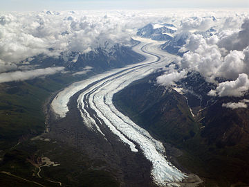 Matanuska Glacier from 20,000 feet (6,100 m)
 -
 Matanuska Glacier terminus


See also
References
This article uses material from the Wikipedia English article Matanuska Glacier, which is released under the Creative Commons Attribution-ShareAlike 3.0 license ("CC BY-SA 3.0"); additional terms may apply (view authors). Content is available under CC BY-SA 4.0 unless otherwise noted. Images, videos and audio are available under their respective licenses.
®Wikipedia is a registered trademark of the Wiki Foundation, Inc. Wiki English (DUHOCTRUNGQUOC.VN) is an independent company and has no affiliation with Wiki Foundation.