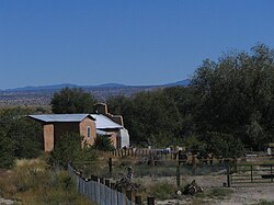
Hernandez, New Mexico
Hernandez is an unincorporated community and census-designated place in Rio Arriba County, New Mexico, United States.
Hernandez is approximately 5 miles (8.0 km) northwest of Española on highway US 84 / US 285.
Hernandez | |
|---|---|
Unincorporated community and CDP | |
 | |
| Country | |
| State | New Mexico |
| County | Rio Arriba |
| Area | |
| • Total | 1.7 sq mi (4 km2) |
| Population (2010) | |
| • Total | 946 |
| Time zone | UTC-7 (Mountain (MST)) |
| • Summer (DST) | UTC-6 (MDT) |
| ZIP code | 87537 |
Geography
Within the unincorporated community is the built-up CDP of Hernandez, with an area of 1.7 square miles (4.4 km2). The Hernandez CDP had a population of 946 in the 2010 census,
The entire Hernandez area (55 square miles (140 km2)) has the ZIP code 87537, pointing to ZIP Code Tabulation Area 87537 (ZCTA), with a population of 2,957 in the 2010 U.S. census.
Demographics
The racial makeup of the Hernandez ZCTA was 58.4% White, 0.4% African American, 2.6% Native American, 0.4% Asian, 35.3% from other races, and 2.9% from two or more races. Hispanic or Latino of any race were 88.9% of the population.
Education
It is in Española Public Schools. Hernandez has one elementary school, Hernandez Elementary. The comprehensive public high school is Española Valley High School.
In popular culture

Hernandez became well known as the site of Moonrise, Hernandez, New Mexico, a black and white photograph taken by Ansel Adams, late in the afternoon on November 1, 1941, from a shoulder of highway US 84 / US 285. The fame of Hernandez grew when an escalation in the market value of photographic works was launched in 1971, when a 1948 print of this image of Hernandez sold at auction "for the then-unheard-of price of $71,500" ($537,900 today), with that same copy selling in 2006 for $609,600 ($921,300 today) at a Sotheby's New York auction.
In 1931, Georgia O'Keeffe visited the community and completed her painting Another Church, Hernandez, New Mexico, showing the front and partial interior of an adobe church in the community.
See also
References
External links
This article uses material from the Wikipedia English article Hernandez, New Mexico, which is released under the Creative Commons Attribution-ShareAlike 3.0 license ("CC BY-SA 3.0"); additional terms may apply (view authors). Content is available under CC BY-SA 4.0 unless otherwise noted. Images, videos and audio are available under their respective licenses.
®Wikipedia is a registered trademark of the Wiki Foundation, Inc. Wiki English (DUHOCTRUNGQUOC.VN) is an independent company and has no affiliation with Wiki Foundation.