Essequibo Islands-West Demerara
Essequibo Islands-West Demerara (Region 3) is a region of Guyana.
It is situated around the Essequibo River, the largest river in Guyana that lies between the Orinoco and Amazon rivers of South America.
Essequibo Islands-West Demerara Region 3 | |
|---|---|
Administrative Region | |
 Arrowpoint | |
.svg) Flag | |
 Map of Guyana showing Essequibo Islands-West Demerara region | |
| Country | |
| Regional Capital | Vreed-en-Hoop |
| Area | |
| • Total | 3,755 km2 (1,450 sq mi) |
| Population (2012 census) | |
| • Total | 107,416 |
| • Density | 29/km2 (74/sq mi) |
It is bordered by the Atlantic Ocean to the north, the region of Demerara-Mahaica and Demerara River to the east, the region of Upper Demerara-Berbice to the south and the region of Pomeroon-Supenaam to the west. In this region are the villages of Parika, Tuschen and Uitvlugt. Along the Essequibo River are 365 islands, of which three of the largest are to be found at the mouth of the Essequibo: Hogg Island, Wakenaam and Leguan.
Population
The Government of Guyana has administered three official censuses since the 1980 administrative reforms, in 1980, 1991 and 2002. In 2002, the population of Essequibo Islands-West Demerara was recorded at 103,061 people. Official census records for the population of Essequibo Islands-West Demerara are as follows:
- 2012: 107,416
- 2002: 103,061
- 1991: 95,975
- 1980: 104,750
Communities
(including name variants):
- Ampa Bay (Post Ampa)
- Anna Catherina
- Caledonia
- Cornelia Ida
- De Jonge Rachael
- De Willem
- Den Amstel (Den Amstel Village, Amstel)
- Fort Island
- Fredericksburg
- Goed Fortuin
- Hague Backdam (Hague Front/Jib, Hague)
- Harlem
- Hogg Island
- Hopetown
- Hubu
- La Parfaite Harmonie
- Leonora
- Louisiana
- Makouria
- McDoom Village (McDoom)
- Met-en-Meerzorg (Meten-Meer-Zorg)
- Melville
- Morasi
- Nismes
- Noitgedacht
- Parika
- Patentia
- Phoenix Town
- Ruimzight
- Santa Mission (Santa Aratak)
- Sarah
- Saxacalli (Saxakalli, Saxsacali)
- Schoonord (SchoonordSchoon Ord)
- Stanleytown
- Stewartville
- Tuschen
- Uitvlugt
- Vergenoegen
- Greenwich Park
- Barnwell
- Philadelphia
- Good Hope
- Ruby
- Farm
- Vreed-en-Hoop
- Vriesland
- Vive-la-force, Guyana
- Windsor Forest
- Zeeburg
- Zeelandia
Gallery
-
 Coconut grove on Wakenaam Island, Essequibo River
 -
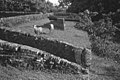 Ruins of Fort Zeelandia on Fort Island, Essequibo River
 -
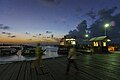 Parika on the east bank of the Essequibo River
 -
 Santa Mission a nature reserve
 -
 Trail in Wakenaam
.jpg)

.jpg)

.jpg)
See also

References
6°42′54″N 58°32′56″W / 6.715056°N 58.54902°W
This article uses material from the Wikipedia English article Essequibo Islands-West Demerara, which is released under the Creative Commons Attribution-ShareAlike 3.0 license ("CC BY-SA 3.0"); additional terms may apply (view authors). Content is available under CC BY-SA 4.0 unless otherwise noted. Images, videos and audio are available under their respective licenses.
®Wikipedia is a registered trademark of the Wiki Foundation, Inc. Wiki English (DUHOCTRUNGQUOC.VN) is an independent company and has no affiliation with Wiki Foundation.