ʻEua
ʻEua ghöört zu dr Inselgrubbe Tongatapu im Köönigriich Tonga.
Es lit öbbe 40 km südöstlig vo dr Hauptinsle Tongatapu und isch geologisch äini vo de eltiste Insle im Pazifik.
| ʻEua | ||
|---|---|---|
 | ||
| Gwässer | Pazifische Ozean | |
| Inselgruppe | Tongatapu-Gruppe (Tonga-Insle) | |
| Geographische Lage | , 174° 56′ W21° 23′ S, 174° 56′ W | |
| ||
| Lengi | 19 km | |
| Breiti | 7,5 km | |
| Flechi | 86,7 km² | |
| Hechschti Hebi | Teʻemoa 312 m | |
| Iiwohner | 5206 (2006) 60 Einw./km² | |
| Hauptort | ʻOhonua | |
 | ||


Geografii
ʻEua isch 19 km lang, 7,5 km bräit und het e Flechi vo 86,7 km².. 5'206 Iiwooner (Stand 2006) läbe dört in 15 Dörfer.
Mä cha vo Nukuʻalofa us mit em Flugzüüg und Schiff uf d Insle choo. Mit em Schiff brucht mä öbbe drei Stunde. Dr grössti Ort und Divisionshauptort isch ʻOhonua (1626 Iiwohoner Taʻanga inkl.). Dört befinde sich alli Instituzioone vo dr Insle, dr Haafe Nafanua, zwäi Supermäärt, d Bost, e Bank und e Tankstell. D Insle het vier Underkünft. Die z Tufu isch gäignet für d Beobachtig vo Walfisch.
D Insle isch seer hügelig und uf eme Däil von ere waggst immer no dichte Räägewald. Dr höggst Punkt uf dr Insle isch dr Teʻemoa mit 312 m über em Meer. E Seenswürdigkäit isch äini vo de grösste und eltiste Birkefiige uf dr Wält.
Dr jöörlig Niiderschlaag lit bi 2700 mm, 2/3 drvo fallt wäärend dr Räägezit vo Novämber bis April.
Weblingg
- D Räägewaldvegetazion vo ʻEua Island (Site cha nüme abgrüeft wärde; Suche im Webarchiv) New Zealand Journal of Botany 1996, pdf (änglisch)
Einzelnachweise
Bildli
-
 Blick uf e Hauptort ʻOhonua, mit Walfisch im Vordergrund
 -
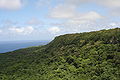 E groosse Däil vo dr Ostsite vo ʻEua ghört zum Eua National Park. Foto mit Blick gege Süde, von ere Blattform am Rand vom Park us.
 -
 Räägewald uf ʻEua


This article uses material from the Wikipedia Alemannisch article ʻEua, which is released under the Creative Commons Attribution-ShareAlike 3.0 license ("CC BY-SA 3.0"); additional terms may apply (view authors). Dr Inhalt isch verfiegbar unter CC BY-SA 4.0, wänn nyt andersch aagee isch. Images, videos and audio are available under their respective licenses.
®Wikipedia is a registered trademark of the Wiki Foundation, Inc. Wiki Alemannisch (DUHOCTRUNGQUOC.VN) is an independent company and has no affiliation with Wiki Foundation.