File:Map of Tokyo Ja.svg

Original file (SVG file, nominally 847 × 635 pixels, file size: 74 KB)
Captions
Captions
Summary[edit]
| Description |
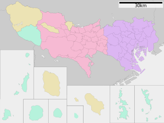
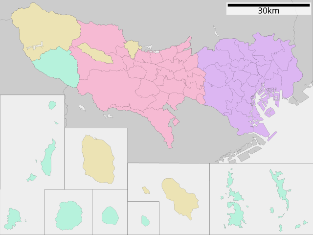
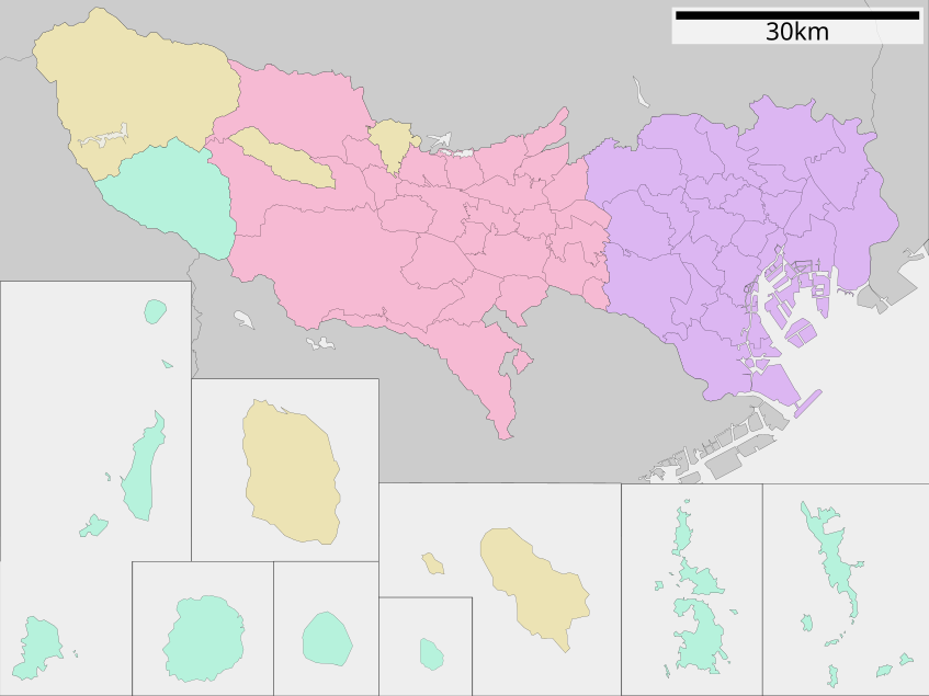
English: Map of Tokyo Prefecture, Japan.
日本語: ja:東京都区画図 |
||
| Date | (UTC) | ||
| Source |
|
||
| Author | Lincun | ||
| Permission (Reusing this file) |
|
Licensing[edit]

|
Permission is granted to copy, distribute and/or modify this document under the terms of the GNU Free Documentation License, Version 1.2 or any later version published by the Free Software Foundation; with no Invariant Sections, no Front-Cover Texts, and no Back-Cover Texts. A copy of the license is included in the section entitled GNU Free Documentation License. |
- You are free:
- to share – to copy, distribute and transmit the work
- to remix – to adapt the work
- Under the following conditions:
- attribution – You must give appropriate credit, provide a link to the license, and indicate if changes were made. You may do so in any reasonable manner, but not in any way that suggests the licensor endorses you or your use.
- share alike – If you remix, transform, or build upon the material, you must distribute your contributions under the same or compatible license as the original.
Original upload log[edit]
| This file was moved from Japanese Wikipedia.
See below for original file information. | ||||||||||||||||||||||||||||||||||||||||||||||||||||||||||||||||||||||||
| ||||||||||||||||||||||||||||||||||||||||||||||||||||||||||||||||||||||||
|
| ||||||||||||||||||||||||||||||||||||||||||||||||||||||||||||||||||||||||
File history
Click on a date/time to view the file as it appeared at that time.
| Date/Time | Thumbnail | Dimensions | User | Comment | |
|---|---|---|---|---|---|
| current | 11:32, 12 February 2023 | | 847 × 635 (74 KB) | Maanshen (talk | contribs) | Fixed border |
| 02:31, 18 January 2023 |  | 847 × 635 (74 KB) | Maanshen (talk | contribs) | Minor changes to borders and boxes are now thinner | |
| 02:04, 18 January 2023 |  | 847 × 635 (74 KB) | Maanshen (talk | contribs) | Fixed ocean color | |
| 02:03, 18 January 2023 |  | 847 × 635 (74 KB) | Maanshen (talk | contribs) | Changes with the outline color for boxes onto black and completely revamped borders | |
| 04:53, 23 August 2019 |  | 800 × 610 (34 KB) | LT sfm (talk | contribs) | Changed the line weight | |
| 04:48, 23 August 2019 |  | 800 × 610 (34 KB) | LT sfm (talk | contribs) | 線の太さ修正 | |
| 04:06, 23 August 2019 |  | 800 × 610 (34 KB) | LT sfm (talk | contribs) | Fixed the color of Hahajima Islands(town to village) | |
| 03:59, 23 August 2019 |  | 800 × 610 (34 KB) | LT sfm (talk | contribs) | 母島列島(小笠原村)が町の配色になっていたのを修正 | |
| 07:42, 9 June 2013 |  | 800 × 610 (45 KB) | ニンジンシチュー (talk | contribs) | デザイン変更(スケールバーの位置、配色) | |
| 07:41, 9 June 2013 |  | 800 × 610 (45 KB) | ニンジンシチュー (talk | contribs) | デザイン変更(スケールバーの位置、配色) |
You cannot overwrite this file.
File usage on Commons
The following 8 pages use this file:
- Maps of Tokyo prefecture
- 東京
- File:2020 Tokyo Gubernatorial Election by municipalities.svg
- File:Map of Tokyo Prefecture.svg (file redirect)
- File:Map of Tokyo Prefecture Ja.svg (file redirect)
- File:包括自治体区画図 13000.svg (file redirect)
File usage on other wikis
The following other wikis use this file:
- Usage on et.wikipedia.org
- Usage on fa.wikipedia.org
- Usage on fi.wikipedia.org
- Usage on fr.wikipedia.org
- Usage on fr.wiktionary.org
- Usage on it.wikipedia.org
- Tokyo
- Shinjuku
- Quartieri speciali di Tokyo
- Musashino
- Mitaka
- Hachiōji
- Minato
- Shibuya
- Inagi
- Adachi (Tokyo)
- Taitō
- Setagaya
- Chiyoda (Tokyo)
- Meguro
- Shinagawa
- Template:Tokyo
- Akiruno
- Akishima
- Chōfu
- Fuchū (Tokyo)
- Hamura
- Higashikurume
- Higashimurayama
- Higashiyamato
- Hino
- Kiyose
- Kodaira
- Koganei
- Kokubunji
- Komae
- Kunitachi
- Machida
- Musashimurayama
- Nishi-Tokyo
- Ōme
- Tachikawa
- Tama (Tokyo)
- Suginami
- Nerima
- Ōta (Tokyo)
- Bunkyō
- Edogawa
- Chūō (Tokyo)
- Kita (Tokyo)
- Kōtō
View more global usage of this file.