File:Массив Ачешбок, Адыгея, Acheshbok, Adygea.jpg
Jump to navigation
Jump to search

Size of this preview: 800 × 532 pixels. Other resolutions: 320 × 213 pixels | 640 × 425 pixels | 1,024 × 680 pixels | 1,280 × 851 pixels | 2,560 × 1,701 pixels | 4,912 × 3,264 pixels.
Original file (4,912 × 3,264 pixels, file size: 13.61 MB, MIME type: image/jpeg)
Captions
Captions
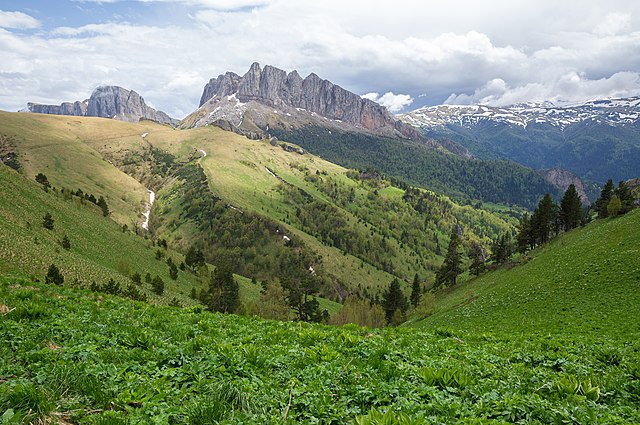
Acheshbok, Adygea, Western Caucasus, Russia.
Summary[edit]
| Description |
English: Acheshbok Massif and Shisha River headwaters, Adygea, Western Caucasus, Russia. These landscapes represent the Early Mesozoic evolution of the Western Caucasus, its Triassic-Jurassic sedimentary and magmatic history.
Русский: Горный массив Ачешбок, перевал Чертовы ворота и верховья реки Шиша ранним летом, Адыгея, Западный Кавказ, Россия. Ландшафты отражают раннемезозойскую эволюцию Западного Кавказа. Триасово-юрские отложения возрастом от 200 миллионов лет. Массив характеризуется высоким ландшафтным и биологическим разнообразием.
Español: Macizo de Acheshbok y cabecera del río Shisha, Adigueya, Cáucaso occidental. El paisaje montañoso representa la evolución mesozoica temprana del Cáucaso occidental.
Українська: Масив Ачешбок і верхів'я річки Шиша, Адигея, Західний Кавказ. Гірський ландшафт представляє ранньомезозойську еволюцію Західного Кавказу. |
| Date | |
| Source | Own work |
| Author | Vyacheslav Argenberg |
| Camera location | | View this and other nearby images on: OpenStreetMap |
|---|
Assessment[edit]
|
This image was selected as picture of the day on Wikimedia Commons for 27 July 2023. It was captioned as follows: English: Acheshbok Massif and Shisha River headwaters, Adygea, Western Caucasus. The mountain landscape represents the Early Mesozoic evolution of the Western Caucasus. The prototype administrative entity of the Republic of Adygea was first established on July 27, 1922. Other languages:
Čeština: Horský masiv Acheshbok a údolí řeky Shisha River v ruské republice Adygejsko, Západní Kavkaz. Území, které představuje ranně druhohorní vývoj západního Kavkazu. Deutsch: Das Acheshbok-Gebirgsmassiv und Oberlauf des Kischa-Flusses in Adygeja, Westkaukasus, Russland. English: Acheshbok Massif and Shisha River headwaters, Adygea, Western Caucasus. The mountain landscape represents the Early Mesozoic evolution of the Western Caucasus. The prototype administrative entity of the Republic of Adygea was first established on July 27, 1922. Español: Macizo de Acheshbok y cabecera del río Shisha, Adigueya, Cáucaso occidental. El paisaje montañoso representa la evolución mesozoica temprana del Cáucaso occidental. Français : Les montagnes Acheshboki situées dans le Caucase de l'Ouest, république d'Adyguée (Russie). Ce paysage montagneux montre l'évolution du Caucase occidental pendant le début du Mésozoïque. Italiano: Il Massiccio Acheshbok e le sorgenti del fiume Kisha, Repubblica di Adighezia, Caucaso occidentale. Questo paesaggio montano rappresenta l'evoluzione di inizio Mesozoico del Caucaso occidentale. Il prototipo di entità amministrativa della Repubblica di Adighezia è stato istituito il 27 luglio 1922. Magyar: Az Acsesbok-hegység és a Sisa folyó forrásvidéke. A hegyvidéki táj a Nyugat-Kaukázus kora-mezozoikumi evolúcióját reprezentálja (Adigeföld, Nyugat-Kaukázus) Português: Maciço de Acheshbok e nascente do rio Shisha, Adigueia, Cáucaso Ocidental. A paisagem montanhosa representa a evolução do início do Mesozoico do Cáucaso Ocidental. Slovenščina: Masiv Ačešbok in izviri reke Šiša; Adigeja, Zahodni Kavkaz. Gorska pokrajina predstavlja zgodnjemezozojski razvoj Zahodnega Kavkaza. Prototipna upravna enota Republika Adigeja je bila prvič ustanovljena 27. julija 1922. Македонски: Масивот Ачешбок и изворот на реката Шиша во Адигеја, Западен Кавказ. Русский: Горный массив Ачешбок и верховья реки Шиша ранним летом, Адыгея, Западный Кавказ, Россия. Массив характеризуется высоким ландшафтным и биологическим разнообразием. Ландшафты отражают раннемезозойскую эволюцию Западного Кавказа. Республика Адыгея впервые была образована 27 июля 1922 года как Адыгейская (Черкесская) автономная область в составе РСФСР. Українська: Масив Ачешбок і верхів'я річки Шиша, Адигея, Західний Кавказ. Гірський ландшафт представляє ранньомезозойську еволюцію Західного Кавказу. Прототип адміністративного утворення Республіки Адигея вперше був створений 27 липня 1922 року.. |

|
This image was taken by Vyacheslav Argenberg
If you have any questions, comments or queries, please contact me. |

|
Licensing[edit]
Vyacheslav Argenberg, the copyright holder of this work, hereby publishes it under the following license:
This file is licensed under the Creative Commons Attribution 4.0 International license.
Attribution: © Vyacheslav Argenberg / http://www.vascoplanet.com/
- You are free:
- to share – to copy, distribute and transmit the work
- to remix – to adapt the work
- Under the following conditions:
- attribution – You must give appropriate credit, provide a link to the license, and indicate if changes were made. You may do so in any reasonable manner, but not in any way that suggests the licensor endorses you or your use.
File history
Click on a date/time to view the file as it appeared at that time.
| Date/Time | Thumbnail | Dimensions | User | Comment | |
|---|---|---|---|---|---|
| current | 11:19, 18 January 2023 | | 4,912 × 3,264 (13.61 MB) | Argenberg (talk | contribs) | Reprocessed for higher fidelity. |
| 12:44, 18 December 2020 |  | 4,912 × 3,264 (10.37 MB) | Argenberg (talk | contribs) | Uploaded own work with UploadWizard |
You cannot overwrite this file.
File usage on Commons
The following 29 pages use this file:
- User:Andrew J.Kurbiko/POTD/2023
- User:Yasir72.multan/POTD Year
- Commons:Featured picture candidates/File:Массив Ачешбок, Адыгея, Acheshbok, Adygea.jpg
- Commons:Featured picture candidates/Log/January 2023
- Commons:Featured pictures/Places/Natural/Russia
- Commons:Featured pictures/chronological/2023-A
- Commons:Featured pictures/chronological/January 2023
- Commons:Picture of the Year/2023/Candidates
- Commons:Picture of the Year/2023/R1/Gallery/2023-A
- Commons:Picture of the Year/2023/R1/Gallery/ALL
- Commons:Picture of the Year/2023/R1/Gallery/M01
- Commons:Quality images/Subject/Places/Natural structures/archive 2021
- Commons:Quality images candidates/Archives January 16 2021
- Template:Potd/2023-07
- Template:Potd/2023-07-27
- Template:Potd/2023-07-27 (cs)
- Template:Potd/2023-07-27 (de)
- Template:Potd/2023-07-27 (en)
- Template:Potd/2023-07-27 (es)
- Template:Potd/2023-07-27 (fr)
- Template:Potd/2023-07-27 (hu)
- Template:Potd/2023-07-27 (it)
- Template:Potd/2023-07-27 (mk)
- Template:Potd/2023-07-27 (myv)
- Template:Potd/2023-07-27 (nl)
- Template:Potd/2023-07-27 (pt)
- Template:Potd/2023-07-27 (ru)
- Template:Potd/2023-07-27 (sl)
- Template:Potd/2023-07-27 (uk)
File usage on other wikis
The following other wikis use this file:
- Usage on alt.wikipedia.org
- Usage on av.wikipedia.org
- Usage on bn.wikipedia.org
- Usage on cv.wikipedia.org
- Usage on fy.wikipedia.org
- Usage on hu.wikipedia.org
- Usage on kk.wikipedia.org
- Usage on ko.wikipedia.org
- Usage on lez.wikipedia.org
- Usage on mk.wikipedia.org
- Usage on os.wikipedia.org
- Usage on pt.wikipedia.org
- Usage on ru.wikipedia.org
- Usage on sah.wikipedia.org
- Usage on sv.wikipedia.org
- Usage on uk.wikipedia.org
- Usage on uz.wikipedia.org
- Usage on vep.wikipedia.org
- Usage on zh.wikipedia.org
Metadata
Categories:
- Mountains of Adygea
- Bolshoy Tkhach Nature Park
- Mountain passes of Russia
- Valleys of Russia
- Endemic flora of Russia
- Views from mountain passes
- River sources
- Wilderness
- Clouds and blue sky in Adygea
- Snow in Europe in June 2015
- Mountains with snow in Russia
- Mountains with clouds in Russia
- 2015 in Adygea
- Spring landscapes in Russia