File:Greater London boroughs 2009 map.svg

Original file (SVG file, nominally 1,425 × 1,140 pixels, file size: 761 KB)
Captions
Captions
Summary[edit]
| Description |
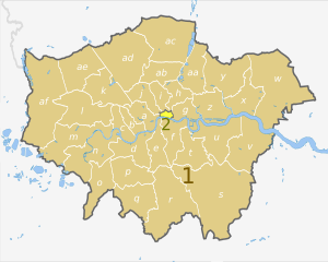
English: Map of Greater London, UK with districts shown, in the same style as other maps of English regions. The county colours are the same as those in File:English metropolitan and non-metropolitan counties 2009.svg.
Equirectangular map projection on WGS 84 datum, with N/S stretched 160%. Geographic limits:
|
| Date | (UTC) |
| Source |
This file was derived from: Greater London UK district map (blank).svg: |
| Author |
|
.svg)
| Map | Ceremonial county | London boroughs |
|---|---|---|
 |
1. Greater London |
a) City of Westminster, b) Kensington and Chelsea, c) Hammersmith and Fulham, d) Wandsworth, e) Lambeth, f) Southwark, g) Tower Hamlets, h) Hackney, i) Islington, j) Camden, k) Brent, l) Ealing, m) Hounslow, n) Richmond, o) Kingston upon Thames, p) Merton, q) Sutton, r) Croydon, s) Bromley, t) Lewisham, u) Greenwich, v) Bexley, w) Havering, x) Barking and Dagenham, y) Redbridge, z) Newham, aa) Waltham Forest, ab) Haringey, ac) Enfield, ad) Barnet, ae) Harrow, af) Hillingdon |
| 2. City of London | ||
| This is a retouched picture, which means that it has been digitally altered from its original version. Modifications: recoloured and labelled in same style as other English regional maps. The original can be viewed here: Greater London UK district map (blank).svg:
|
Licensing[edit]
- You are free:
- to share – to copy, distribute and transmit the work
- to remix – to adapt the work
- Under the following conditions:
- attribution – You must give appropriate credit, provide a link to the license, and indicate if changes were made. You may do so in any reasonable manner, but not in any way that suggests the licensor endorses you or your use.
- share alike – If you remix, transform, or build upon the material, you must distribute your contributions under the same or compatible license as the original.
Original upload log[edit]
This image is a derivative work of the following images:
- File:Greater_London_UK_district_map_(blank).svg licensed with Cc-by-sa-3.0
- 2010-08-22T08:09:33Z Nilfanion 1425x1140 (1104179 Bytes) +inset, water colour tweak
- 2010-07-16T23:35:33Z Nilfanion 1425x1140 (738807 Bytes) {{Information |Description=Map of [[w:Greater London|Greater London]], UK with districts shown. Equirectangular map projection on WGS 84 datum, with N/S stretched 160% Geographic limits: *West: 0.57W *East: 0.37E *North: 51
Uploaded with derivativeFX
File history
Click on a date/time to view the file as it appeared at that time.
| Date/Time | Thumbnail | Dimensions | User | Comment | |
|---|---|---|---|---|---|
| current | 22:05, 2 May 2012 | | 1,425 × 1,140 (761 KB) | Dr Greg (talk | contribs) | == {{int:filedesc}} == {{Information |Description={{en|Map of Greater London, UK with districts shown, in the same style as other maps of English regions. The county colours are the same as those in [[:File:English metropolitan and... |
You cannot overwrite this file.
File usage on Commons
The following 2 pages use this file:
File usage on other wikis
The following other wikis use this file:
- Usage on ar.wikipedia.org
- Usage on de.wikipedia.org
- Usage on en.wikipedia.org
- Usage on fr.wikipedia.org
- Usage on pnb.wikipedia.org
- Usage on th.wikipedia.org
- Usage on ur.wikipedia.org
- Usage on zh-yue.wikipedia.org