File:Mauritius rel90.jpg
Jump to navigation
Jump to search

Size of this preview: 497 × 599 pixels. Other resolutions: 199 × 240 pixels | 398 × 480 pixels | 1,000 × 1,206 pixels.
Original file (1,000 × 1,206 pixels, file size: 236 KB, MIME type: image/jpeg)
Captions
Captions
Add a one-line explanation of what this file represents
Summary[edit]
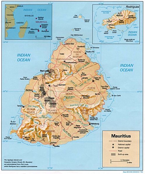
| Description | Relief map of Mauritius, with inset of Rodrigues Island. US Central Intelligence Agency, 1990. |
| Date | |
| Source | University of Texas Libraries, Perry-Castañeda Library Map Collection: Mauritius Maps |
| Author | CIA |
Licensing[edit]
| This image is a work of a Central Intelligence Agency employee, taken or made as part of that person's official duties. As a Work of the United States Government, this image or media is in the public domain in the United States.
|

|
File history
Click on a date/time to view the file as it appeared at that time.
| Date/Time | Thumbnail | Dimensions | User | Comment | |
|---|---|---|---|---|---|
| current | 22:31, 11 December 2006 | | 1,000 × 1,206 (236 KB) | Electionworld (talk | contribs) | {{ew|en|Tom Radulovich}} {{PD-USGov-CIA}} Relief map of {{link|Mauritius}}, with inset of Rodrigues Island. US Central Intelligence Agency, 1990. |
You cannot overwrite this file.
File usage on Commons
The following 2 pages use this file:
File usage on other wikis
The following other wikis use this file:
- Usage on fr.wikipedia.org
- Usage on gd.wikipedia.org
- Usage on hr.wiktionary.org
- Usage on ht.wikipedia.org
- Usage on ru.wikipedia.org
- Usage on sr.wikipedia.org
- Usage on uk.wikipedia.org
- Usage on vec.wikipedia.org
- Usage on vep.wikipedia.org
- Usage on www.wikidata.org
- Usage on yo.wikipedia.org
- Usage on zh.wikipedia.org