File:MapRegionsRomania.png

Original file (1,000 × 786 pixels, file size: 248 KB, MIME type: image/png)
Captions
Captions
Licensing[edit]

|
Permission is granted to copy, distribute and/or modify this document under the terms of the GNU Free Documentation License, Version 1.2 or any later version published by the Free Software Foundation; with no Invariant Sections, no Front-Cover Texts, and no Back-Cover Texts. A copy of the license is included in the section entitled GNU Free Documentation License.http://www.gnu.org/copyleft/fdl.htmlGFDLGNU Free Documentation Licensetruetrue |
| This file is licensed under the Creative Commons Attribution-Share Alike 3.0 Unported license. | ||
| ||
| This licensing tag was added to this file as part of the GFDL licensing update.http://creativecommons.org/licenses/by-sa/3.0/CC BY-SA 3.0Creative Commons Attribution-Share Alike 3.0truetrue |
Summary[edit]
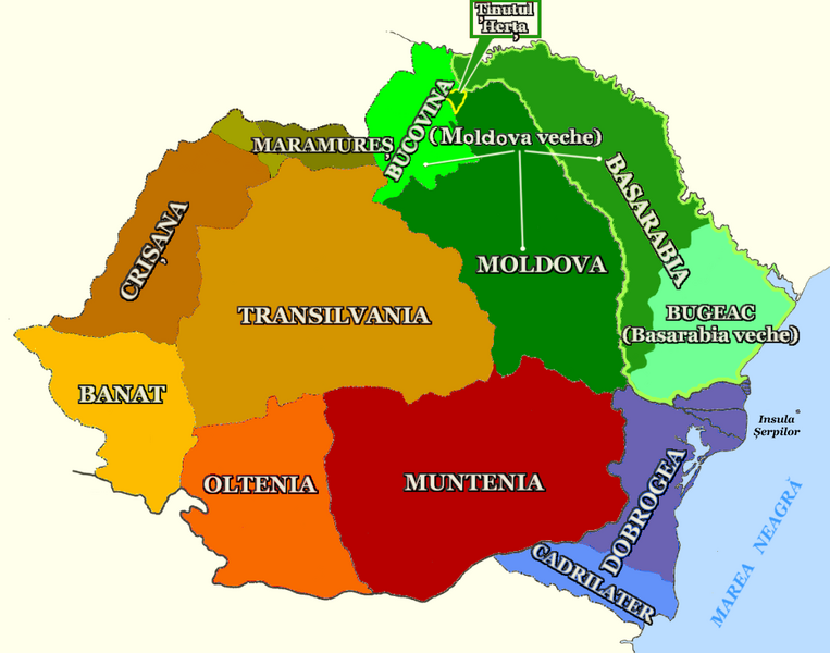
Historical provinces, into the borders of the "greater Romania". Some of the provinces were shared with Yugoslavia, Bulgaria, Hungary and Czecoslovakia:
- Banat: Romanian part of the region between the rivers Mureş (N), Tisa (W), Danube (S), Cerna and Timiş (E).
- Basarabia (Bessarabia): Since 1812, region between Pruth river (W), Dniester river (E, N), Black Sea (S) and Bucovina, coresponding with the part of Moldavia annexed by the Russian Empire in 1812. Until 1812, the south-east region of Moldavia (Basarabia veche), between the Pruth-Danube confluence and the mouths of Dniestr, next the Danube and the Black Sea, annexed by the Ottoman Empire in 1484, 1536 and 1538, and called in turkish Bucak (russian Budjak, romanian Bugeac).
- Bucovina: Region from Moldavia anexed by the Habsburg Empire in 1774.
- Crişana: Region between the Bihor or Apuseni Mts (E) and the rivers Mureş (S), Someş (N) and Tisa (W).
- Dobrogea (Dobruja): Region between Danube (W, N), Black Sea (E, SE), and the Turtucaia/Tutrakan-Ecrina/Kranevo line (S). It consists of the romanian Northern Dobruja and the bulgarian Southern Dobruja (or Cadrilater, a region from Bulgaria annexed by Romania in 1913, and given back in 1940).
- Maramureş: Romanian part of the old Marmatian voivodate, divided into romanian Maramureş and ukrainian Transcarpathian Ruthenia.
- Moldova: In the Medieval Age, the Principality of Moldavia (Moldova veche, old Moldavia in romanian) included the regions later called Bucovina (1775) and Bessarabia (1812). Since 1812, the name Moldavia (Moldova in Romanian) concerns the region between Carpathian Mts (W), Pruth river (E), Milcov, Sereth, Danube rivers (S) and Bucovina (N). In english, the name Moldova is also in use, but for the independent post-soviet republic (Moldavian SSR but Republic of Moldova).
- Muntenia (Great Wallachia): Region between Transylvanian Alps, Milcov and Sireth rivers (N), Danube (S, E) and Olt river (W).
- Oltenia (Little Wallachia): Region between Transylvanian Alps (N), Olt river (E), and Danube (W, S). Some sources pushes the eastern border over Olt river, on the Limes Transalutanus, and western border into the east part of the Banat, on the Severin Banat or Vâlcu/Valko region.
- Transilvania (Transylvania): Region between the Carpathian Mts, bordered by the following provinces: Maramureş, Bucovina (N), Moldova (E), Muntenia, Oltenia (S), Banat and Crişana (W). Between 1570 and 1699, the Transylvanian Principality included this area and also the Crişana, the Maramureş and some other parts of the Eastern Hungarian Kingdom (partium). Today the name Transilvania is frequently used including also Crişana, Maramureş and romanian Banat.
- Ţinutul Herţa: Herţa was a small part of Moldova, betwenn Bucovina and Bessarabia, annexed by the USSR in 1940, apart from their official ultimatum.
File history
Click on a date/time to view the file as it appeared at that time.
| Date/Time | Thumbnail | Dimensions | User | Comment | |
|---|---|---|---|---|---|
| current | 10:28, 11 May 2015 |  | 1,000 × 786 (248 KB) | Spiridon Ion Cepleanu (talk | contribs) | Cosmetic changes |
| 11:05, 26 January 2014 |  | 1,000 × 786 (240 KB) | Spiridon Ion Cepleanu (talk | contribs) | Rectified mistake, signaled by Benutzer:JøMa (Danke). | |
| 19:34, 14 January 2014 |  | 1,000 × 786 (239 KB) | Spiridon Ion Cepleanu (talk | contribs) | Little changes since maps of years 1806, 1914 & 1925-35 | |
| 17:36, 22 March 2007 |  | 1,000 × 786 (232 KB) | Alex:D (talk | contribs) | Corected map | |
| 15:33, 18 September 2006 |  | 1,000 × 786 (237 KB) | Alex:D (talk | contribs) | Regions of Romania Category:Maps of the history of Romania |
You cannot overwrite this file.
File usage on Commons
The following 6 pages use this file:
File usage on other wikis
The following other wikis use this file:
- Usage on an.wikipedia.org
- Usage on be.wikipedia.org
- Usage on bg.wikipedia.org
- Usage on ca.wikipedia.org
- Usage on da.wikipedia.org
- Usage on de.wikipedia.org
- Usage on eo.wikipedia.org
- Usage on fi.wikipedia.org
- Usage on fr.wikipedia.org
- Principauté de Valachie
- Transylvanie (région)
- Bucovine
- Dobroudja
- Marmatie
- Banat historique
- Munténie
- Olténie
- Modèle:Palette Régions historiques de Roumanie
- Crișana
- Boudjak
- Principauté de Transylvanie
- Transylvanie austro-hongroise
- Régions historiques de Roumanie
- Portail transylvain en bois
- Raion de Herța
- Histoire de la Transylvanie
- Traité de Bucarest (1916)
- Bessarabie
- Moldavie (région historique)
- Discussion:Moldavie (région historique)
- Dobroudja du Sud
- Vallée d'Almaj
- Wikipédia:Atelier graphique/Cartes/Archives/juin 2009
- Pays de Călata
View more global usage of this file.
Metadata
This file contains additional information such as Exif metadata which may have been added by the digital camera, scanner, or software program used to create or digitize it. If the file has been modified from its original state, some details such as the timestamp may not fully reflect those of the original file. The timestamp is only as accurate as the clock in the camera, and it may be completely wrong.
| Horizontal resolution | 28.35 dpc |
|---|---|
| Vertical resolution | 28.35 dpc |