File:Spanish Empire Anachronous 0.PNG
Jump to navigation
Jump to search

Size of this preview: 800 × 406 pixels. Other resolutions: 320 × 162 pixels | 640 × 325 pixels | 1,024 × 520 pixels | 1,280 × 650 pixels | 2,752 × 1,397 pixels.
Original file (2,752 × 1,397 pixels, file size: 791 KB, MIME type: image/png)
Captions
Captions
Add a one-line explanation of what this file represents

|
File:Spanish Empire Anachronous en.svg is a vector version of this file. It should be used in place of this PNG file when not inferior.
File:Spanish Empire Anachronous 0.PNG → File:Spanish Empire Anachronous en.svg
For more information, see Help:SVG. |
 |
Summary[edit]
| Description |
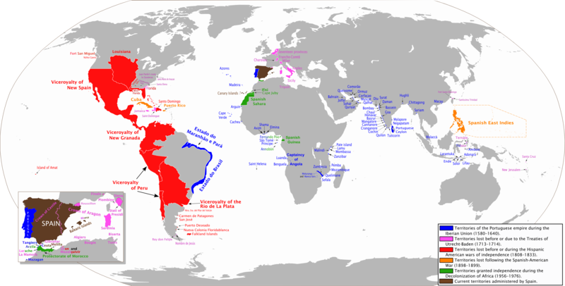
Español: Mapa diacrónico de los territorios del Imperio Español
Territorios del imperio portugués durante la Unión Ibérica (1580-1640)
Territorios perdidos hasta los Tratados de Utrecht-Baden (1713–1714)
Territorios perdidos hasta las Guerras de independencia hispanoamericana (1808-1833)
Territorios perdidos debido a la Guerra Hispano-Estadounidense (1898-1899)
Territorios perdidos debido a la Descolonización de África (1956-1976)
Territorios actualmente administrados por España English: Anachronous map of the Spanish Empire
Territories of the Portuguese empire during the Iberian Union (1580-1640)
Territories lost before or due to the Treaties of Utrecht-Baden (1713–1714)
Territories lost before or during the Spanish American wars of independence (1808-1833)
Territories lost following the Spanish-American War (1898-1899)
Territories granted independence during the Decolonization of Africa (1956-1976)
Current territories administered by Spain |
| Date | |
| Source | Own work. View sources in talk page |
| Author | Trasamundo |
| Other versions | Image:Spanish Empire Anachronous en.svg, File:Spanish Empire Anachronous 0-ar.png |
Licensing[edit]
I, the copyright holder of this work, hereby publish it under the following licenses:

|
Permission is granted to copy, distribute and/or modify this document under the terms of the GNU Free Documentation License, Version 1.2 or any later version published by the Free Software Foundation; with no Invariant Sections, no Front-Cover Texts, and no Back-Cover Texts. A copy of the license is included in the section entitled GNU Free Documentation License. |
This file is licensed under the Creative Commons Attribution-Share Alike 3.0 Unported, 2.5 Generic, 2.0 Generic and 1.0 Generic license.
- You are free:
- to share – to copy, distribute and transmit the work
- to remix – to adapt the work
- Under the following conditions:
- attribution – You must give appropriate credit, provide a link to the license, and indicate if changes were made. You may do so in any reasonable manner, but not in any way that suggests the licensor endorses you or your use.
- share alike – If you remix, transform, or build upon the material, you must distribute your contributions under the same or compatible license as the original.
You may select the license of your choice.
File history
Click on a date/time to view the file as it appeared at that time.
| Date/Time | Thumbnail | Dimensions | User | Comment | |
|---|---|---|---|---|---|
| current | 21:21, 9 June 2013 | | 2,752 × 1,397 (791 KB) | Trasamundo (talk | contribs) | Oceanía |
| 19:23, 28 January 2013 |  | 2,752 × 1,397 (786 KB) | Trasamundo (talk | contribs) | dates | |
| 19:57, 6 September 2012 |  | 2,752 × 1,397 (785 KB) | Trasamundo (talk | contribs) | Iberian Peninsula | |
| 21:26, 29 March 2011 |  | 2,752 × 1,397 (769 KB) | Trasamundo (talk | contribs) | North Amarica: fixing the geographical accuracy, missions, forts | |
| 15:49, 27 February 2011 |  | 2,752 × 1,397 (764 KB) | Trasamundo (talk | contribs) | Spanish East Indies: limits | |
| 15:03, 9 July 2010 |  | 2,753 × 1,400 (763 KB) | Trasamundo (talk | contribs) | New sources: Brazil, Angola, mozambique, Juan Pardo | |
| 00:20, 29 March 2010 |  | 2,753 × 1,400 (706 KB) | Trasamundo (talk | contribs) | Fixing the geographical accuracy | |
| 00:34, 11 January 2010 |  | 2,752 × 1,397 (611 KB) | Trasamundo (talk | contribs) | Añado Siena, Piombino, Finale | |
| 17:20, 27 June 2009 |  | 2,753 × 1,400 (743 KB) | Trasamundo (talk | contribs) | Añado Lifau (Timor) | |
| 19:01, 29 March 2009 |  | 2,753 × 1,400 (735 KB) | Trasamundo (talk | contribs) | Mejor resolución |
You cannot overwrite this file.
File usage on Commons
The following 20 pages use this file:
- Atlas of Argentina
- Atlas of Costa Rica
- Atlas of Cuba
- Atlas of Spain
- Atlas of colonialism
- Atlas of the early modern age
- Atlas of world history
- User:DMY/sandbox
- Commons:Deletion requests/Archive/2010/01/06
- Commons:Deletion requests/Archive/2010/02/02
- Commons:Deletion requests/File:666333.PNG
- Commons:Deletion requests/File:CorrectoImperioEspañol.png
- Commons:Deletion requests/File:Hahaharedhatofpatferrick.PNG
- Commons:Deletion requests/File:HispaniaRegnum-World.png
- Commons:Deletion requests/File:Imperioespañol1402.PNG
- Commons:Deletion requests/File:SpanishEmpire1975.PNG
- Commons:Deletion requests/File:SpanishEmpireHRE.PNG
- Commons:Deletion requests/File:SpanishEmpireanachronic.png
- File:Spanish Empire Anachronous 0-ar.png
- File:Spanish Empire Anachronous en.svg
File usage on other wikis
The following other wikis use this file:
- Usage on ar.wikipedia.org
- Usage on ast.wikipedia.org
- Usage on azb.wikipedia.org
- Usage on az.wikipedia.org
- Usage on ba.wikipedia.org
- Usage on be.wikipedia.org
- Usage on bg.wikipedia.org
- Usage on br.wikipedia.org
- Usage on ca.wikipedia.org
- Usage on cbk-zam.wikipedia.org
- Usage on cs.wikipedia.org
- Usage on cv.wikipedia.org
- Usage on cy.wikipedia.org
- Usage on da.wikipedia.org
- Usage on de.wikipedia.org
- Usage on el.wikipedia.org
- Usage on en.wikipedia.org
- Usage on en.wikibooks.org
- Usage on eo.wikipedia.org
- Usage on es.wikipedia.org
- Usage on et.wikipedia.org
- Usage on eu.wikipedia.org
View more global usage of this file.