File:ROC Matsu.png
Jump to navigation
Jump to search

Size of this preview: 800 × 444 pixels. Other resolutions: 320 × 178 pixels | 640 × 355 pixels | 1,000 × 555 pixels.
Original file (1,000 × 555 pixels, file size: 35 KB, MIME type: image/png)
Captions
Captions
Add a one-line explanation of what this file represents
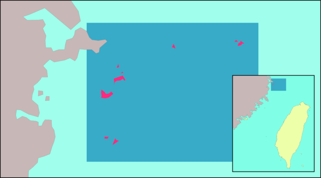
en: Location of Matsu Islands relative to Taiwan and mainland China. Made by uploader using Image:Taiwan Strait.png as base map. Borders were taken from zh:User:試吃那人's locator maps for Taiwanese counties. The faded box idea was borrowed from User:Nichalp's locator maps for Indian states.
zh: 馬祖列島相對於臺灣以及中國大陸的位置圖。上傳者以Image:Taiwan Strait.png為底圖自行製作。縣界來源為zh:User:試吃那人所繪製的臺灣縣市位置圖,淺色框襯托深色地區的創意來源為User:Nichalp所繪製的印度各邦位置圖。

|
Permission is granted to copy, distribute and/or modify this document under the terms of the GNU Free Documentation License, Version 1.2 or any later version published by the Free Software Foundation; with no Invariant Sections, no Front-Cover Texts, and no Back-Cover Texts. A copy of the license is included in the section entitled GNU Free Documentation License. |
| This file is licensed under the Creative Commons Attribution-Share Alike 3.0 Unported license. | ||
| ||
| This licensing tag was added to this file as part of the GFDL licensing update. |
File history
Click on a date/time to view the file as it appeared at that time.
| Date/Time | Thumbnail | Dimensions | User | Comment | |
|---|---|---|---|---|---|
| current | 09:47, 16 July 2011 | | 1,000 × 555 (35 KB) | Energiya (talk | contribs) | Zoom on the county |
| 20:14, 16 May 2005 |  | 362 × 425 (11 KB) | Ran (talk | contribs) | Location of the Matsu Islands relative to Taiwan and mainland China. Made by uploader using Image:Taiwan Strait.png as base map. The box idea was borrowed from User:Nichalp's locator maps for small Indian states. {{GFDL}} |
You cannot overwrite this file.
File usage on Commons
The following page uses this file:
File usage on other wikis
The following other wikis use this file:
- Usage on ca.wikipedia.org
- Usage on cs.wikipedia.org
- Usage on en.wikipedia.org
- Usage on eu.wikipedia.org
- Usage on ko.wikipedia.org
- Usage on uk.wikipedia.org
- Usage on vi.wikipedia.org
- Usage on www.wikidata.org
- Usage on zh-min-nan.wikipedia.org
- Usage on zh-min-nan.wiktionary.org
- Usage on zh.wikipedia.org
- Usage on zh.wiktionary.org