File:Map of Tibet Ü-Tsang Amdo and Kham.jpg
Jump to navigation
Jump to search
No higher resolution available.
Map_of_Tibet_Ü-Tsang_Amdo_and_Kham.jpg (295 × 187 pixels, file size: 25 KB, MIME type: image/jpeg)
Captions
Captions
Add a one-line explanation of what this file represents
Summary[edit]
| Description |
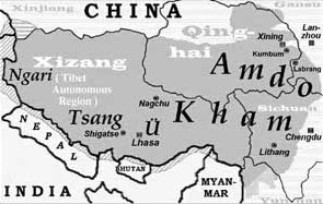
(Karte: A. Gruschke, Freiburg) New version File:Tibet provinces.png |
| Date | 7 December 2006 (original upload date) |
| Source | found in "Die Jonangpa in Osttibet", Grundlagen der Entwicklung, des Niedergangs und Überdauerns einer lange vergessenen tibetisch-buddhistischen Schulrichtung |
| Author | Andreas Gruschke, Institute of Social Development & Western China Development Studies · Sichuan University, Chengdu, P.R. China |
| Permission (Reusing this file) |
file uploaded by original author |
Licensing[edit]
I, the copyright holder of this work, hereby publish it under the following license:
This file is licensed under the Creative Commons Attribution-Share Alike 2.5 Generic license.
- You are free:
- to share – to copy, distribute and transmit the work
- to remix – to adapt the work
- Under the following conditions:
- attribution – You must give appropriate credit, provide a link to the license, and indicate if changes were made. You may do so in any reasonable manner, but not in any way that suggests the licensor endorses you or your use.
- share alike – If you remix, transform, or build upon the material, you must distribute your contributions under the same or compatible license as the original.
File history
Click on a date/time to view the file as it appeared at that time.
| Date/Time | Thumbnail | Dimensions | User | Comment | |
|---|---|---|---|---|---|
| current | 23:19, 19 July 2010 | | 295 × 187 (25 KB) | Beao (talk | contribs) | Removed border. |
| 09:13, 7 December 2006 |  | 300 × 192 (26 KB) | Gruschke (talk | contribs) | Lage der osttibetischen Regionen Amdo und Kham (Karte: A. Gruschke, Freiburg) |
You cannot overwrite this file.
File usage on Commons
The following 8 pages use this file:
File usage on other wikis
The following other wikis use this file:
- Usage on af.wikipedia.org
- Usage on bo.wikipedia.org
- Usage on br.wikipedia.org
- Usage on cs.wikipedia.org
- Usage on cy.wikipedia.org
- Usage on da.wikipedia.org
- Usage on de.wikipedia.org
- Usage on en.wikipedia.org
- Usage on eo.wikipedia.org
- Usage on es.wikipedia.org
- Usage on fr.wikipedia.org
- Usage on ga.wikipedia.org
- Usage on id.wikipedia.org
- Usage on it.wikipedia.org
- Usage on ja.wikipedia.org
- Usage on ka.wikipedia.org
- Usage on ko.wikipedia.org
View more global usage of this file.