File:Map of The east barbarian 0.png
Jump to navigation
Jump to search

Size of this preview: 690 × 600 pixels. Other resolutions: 276 × 240 pixels | 552 × 480 pixels | 884 × 768 pixels | 1,077 × 936 pixels.
Original file (1,077 × 936 pixels, file size: 469 KB, MIME type: image/png)
Captions
Captions
Add a one-line explanation of what this file represents
Summary[edit]
| Description |
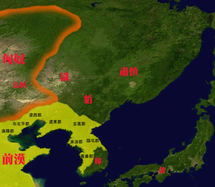
日本語: 紀元前1世紀頃の東夷諸国。
中文:公元前1世紀初(漢武帝末年)的西漢東北疆域與東夷諸國。 |
| Date | |
| Source | File:Whole world - land and oceans 12000.jpg modified by トムル、『増補版 標準世界史地図』(吉川弘文館、2022年) |
| Author | トムル |
Licensing[edit]
| I, the copyright holder of this work, release this work into the public domain. This applies worldwide. In some countries this may not be legally possible; if so: I grant anyone the right to use this work for any purpose, without any conditions, unless such conditions are required by law. |
File history
Click on a date/time to view the file as it appeared at that time.
| Date/Time | Thumbnail | Dimensions | User | Comment | |
|---|---|---|---|---|---|
| current | 07:05, 19 October 2010 | | 1,077 × 936 (469 KB) | トムル (talk | contribs) | {{Information |Description={{ja|1=紀元前1世紀頃の東夷諸国。}} |Source=File:Whole world - land and oceans.jpg |Author=トムル |Date=2010.10.19 |Permission= |other_versions= }} Category:Maps of Manchuria Category:Maps of East Asia |
You cannot overwrite this file.
File usage on Commons
There are no pages that use this file.
File usage on other wikis
The following other wikis use this file:
- Usage on en.wikipedia.org
- Usage on fa.wikipedia.org
- Usage on incubator.wikimedia.org
- Usage on ja.wikipedia.org
- Usage on ms.wikipedia.org
- Usage on uk.wikipedia.org
- Usage on vi.wikipedia.org
- Usage on www.wikidata.org
- Usage on zh-min-nan.wikipedia.org
- Usage on zh-yue.wikipedia.org
- Usage on zh.wikipedia.org