File:Limes3.png
Jump to navigation
Jump to search

Size of this preview: 800 × 360 pixels. Other resolutions: 320 × 144 pixels | 640 × 288 pixels | 1,024 × 461 pixels | 1,280 × 577 pixels | 2,362 × 1,064 pixels.
Original file (2,362 × 1,064 pixels, file size: 709 KB, MIME type: image/png)
Captions
Captions
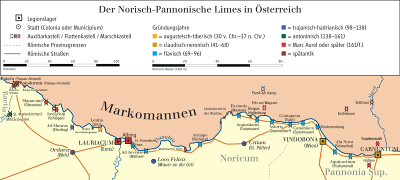
Map of Limes in Austria (system of fortifications representing the boundary of Roman control)
Summary[edit]
| Description |
English: Map of Limes in Austria (system of fortifications representing the boundary of Roman control)
Deutsch: Karte des norisch-pannonischen Limes in Österreich. Suchbegriffe: Markomannen, Raetia, Inn, Batava (Passau), Boiotro (Passau), Burgus Passau-Haibach, Stanacum (Oberanna), Ioviacum (Schlögen), Ad Mauros (Eferding), Ovilava (Wels), Burgus Hirschleitengraben, Lentia (Linz), Lauriacum (Enns) Albing, St. Pantaleon-Stein, Ad Juvense (Wallsee), Danubia, Loco Felicis (Mauer an der Url), Wachtürme Ybbs, Arelape (Pöchlarn), Noricum, Limestürme in der Wachau, Favianis (Mautern) Plank am Kamp, Fels am Wagram, Augustianus (Traismauer), Cetium (St. Pölten), Asturis (Zwentendorf), Comagena (Tulln), Canabiaca (Zeiselmauer), Klosterneuburg, Vindobona (Wien), Kollnbrunn, Stillfried, March, Ala Nova (Schwechat), Aquinoctium (Fischamend), Engehartstetten, Carnuntum, Höflein, Pannonia Sup. |
| Date | |
| Source | Own work/Source of Information: Putzger – Historischer Weltatlas, 89. Auflage, 1965; Westermanns Großer Atlas zur Weltgeschichte, 1978 |
| Author | Ziegelbrenner |
| Other versions | File:NPL1.png |
Licensing[edit]
I, the copyright holder of this work, hereby publish it under the following licenses:

|
Permission is granted to copy, distribute and/or modify this document under the terms of the GNU Free Documentation License, Version 1.2 or any later version published by the Free Software Foundation; with no Invariant Sections, no Front-Cover Texts, and no Back-Cover Texts. A copy of the license is included in the section entitled GNU Free Documentation License. |
This file is licensed under the Creative Commons Attribution-Share Alike 3.0 Unported, 2.5 Generic, 2.0 Generic and 1.0 Generic license.
- You are free:
- to share – to copy, distribute and transmit the work
- to remix – to adapt the work
- Under the following conditions:
- attribution – You must give appropriate credit, provide a link to the license, and indicate if changes were made. You may do so in any reasonable manner, but not in any way that suggests the licensor endorses you or your use.
- share alike – If you remix, transform, or build upon the material, you must distribute your contributions under the same or compatible license as the original.
You may select the license of your choice.

|
This map has been made or improved in the German Kartenwerkstatt (Map Lab). You can propose maps to improve as well.
|
File history
Click on a date/time to view the file as it appeared at that time.
| Date/Time | Thumbnail | Dimensions | User | Comment | |
|---|---|---|---|---|---|
| current | 18:45, 14 April 2020 | | 2,362 × 1,064 (709 KB) | Veleius (talk | contribs) | Spätantike Burgi nachgetragen. |
| 18:35, 13 April 2020 |  | 2,362 × 1,064 (733 KB) | Veleius (talk | contribs) | Das 2017 entdeckte Kastell St. Pantaleon-Stein ergänzt. | |
| 10:35, 30 June 2015 |  | 2,362 × 1,064 (624 KB) | Mediatus (talk | contribs) | gef. | |
| 10:11, 30 June 2015 |  | 2,362 × 1,064 (624 KB) | Mediatus (talk | contribs) | nochmals aktualisiert | |
| 10:09, 30 June 2015 |  | 2,362 × 1,064 (607 KB) | Mediatus (talk | contribs) | aktualisiert | |
| 15:45, 3 January 2011 |  | 2,362 × 1,064 (610 KB) | Ziegelbrenner (talk | contribs) | 2011-01-03 | |
| 15:39, 3 January 2011 |  | 2,362 × 1,064 (611 KB) | Ziegelbrenner (talk | contribs) | 2011-01-03 | |
| 11:46, 11 January 2010 |  | 2,362 × 1,064 (604 KB) | Ziegelbrenner (talk | contribs) | 2010-01-11 | |
| 10:34, 24 November 2009 |  | 2,362 × 1,181 (634 KB) | Ziegelbrenner (talk | contribs) | 2009-11-24 | |
| 12:00, 25 September 2009 |  | 2,657 × 1,181 (702 KB) | Ziegelbrenner (talk | contribs) | 2009-09-25 |
You cannot overwrite this file.
File usage on Commons
The following 2 pages use this file:
File usage on other wikis
The following other wikis use this file:
- Usage on ast.wikipedia.org
- Usage on az.wikipedia.org
- Usage on bg.wikipedia.org
- Usage on cs.wikipedia.org
- Usage on de.wikipedia.org
- Niederösterreich
- Vindobona
- Carnuntum (Militärlager)
- Limes (Grenzwall)
- Kastell Boiotro
- Eichgraben
- Lauriacum
- Geschichte Niederösterreichs
- Donaulimes
- Aelium Cetium
- Wikipedia:Redaktion Altertum/Römischer Limes
- Wikipedia:Redaktion Altertum/Römischer Limes/Pictothek
- Benutzer Diskussion:Ziegelbrenner/Archiv 2009
- Kastell Zeiselmauer
- Liste der Kastelle in Noricum und Oberpannonien
- Limestürme in der Wachau
- Kleinkastell Stopfenreuth
- Kleinkastell Höflein
- Kastell Aequinoctium
- Wikipedia:Kartenwerkstatt/Archiv/2009-08
- Kastell Klosterneuburg
- Kastell Ala Nova
- Kastell Zwentendorf
- Kleinkastell Schlögen
- Kastell Traismauer
- Burgus Hollenburg
- Comagena
- Kastell Favianis
- Kastell Melk
- Legionslager Albing
- Kastell Pöchlarn
- Wachtürme Ybbs
- Kastell Wallsee
- Wikipedia:Redaktion Altertum/Römischer Limes/Limeskongress 2011/Übernachtung
- Lentia (Noricum)
- Kastell Eferding
- Wachturm Hirschleitengraben
- Burgus Oberranna
- Locus Felicis
- Selbstbetrachtungen
- Burgus Passau-Haibach
- Benutzer:Ziegelbrenner/Meine Bilder auf Commons
- Römische Streitkräfte in Noricum
View more global usage of this file.