File:Lược đồ vùng kiểm soát các phe năm 1790 trong cuộc nội chiến tại Đại Việt.svg
Jump to navigation
Jump to search

Size of this PNG preview of this SVG file: 483 × 599 pixels. Other resolutions: 193 × 240 pixels | 387 × 480 pixels | 619 × 768 pixels | 826 × 1,024 pixels | 1,651 × 2,048 pixels | 512 × 635 pixels.
Original file (SVG file, nominally 512 × 635 pixels, file size: 118 KB)
Captions
Captions
Add a one-line explanation of what this file represents
Summary[edit]
| Description |
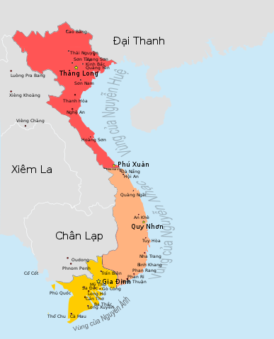
Tiếng Việt: Nguồn svg bản đồ Việt Nam https://commons.wikimedia.org/wiki/File:Vietnam_map.svg; lược đồ Đại Việt 1790 trong sách Histoire du Viêt Nam, des origines à 1858 |
| Date | Ngày tải lên |
| Source | Own work |
| Author | Lão Ngoan Đồng (thảo luận) |
| Other versions | Không có |
Licensing[edit]
I, the copyright holder of this work, hereby publish it under the following license:
This file is licensed under the Creative Commons Attribution 3.0 Unported license.
- You are free:
- to share – to copy, distribute and transmit the work
- to remix – to adapt the work
- Under the following conditions:
- attribution – You must give appropriate credit, provide a link to the license, and indicate if changes were made. You may do so in any reasonable manner, but not in any way that suggests the licensor endorses you or your use.
File history
Click on a date/time to view the file as it appeared at that time.
| Date/Time | Thumbnail | Dimensions | User | Comment | |
|---|---|---|---|---|---|
| current | 20:05, 24 July 2016 | | 512 × 635 (118 KB) | Lão Ngoan Đồng (talk | contribs) | |
| 19:35, 24 July 2016 |  | 512 × 635 (67 KB) | Lão Ngoan Đồng (talk | contribs) | ||
| 19:34, 24 July 2016 |  | 512 × 635 (67 KB) | Lão Ngoan Đồng (talk | contribs) | ||
| 19:31, 24 July 2016 |  | 512 × 635 (68 KB) | Lão Ngoan Đồng (talk | contribs) | ||
| 19:10, 24 July 2016 |  | 512 × 635 (69 KB) | Lão Ngoan Đồng (talk | contribs) | ||
| 19:09, 24 July 2016 |  | 512 × 635 (69 KB) | Lão Ngoan Đồng (talk | contribs) | ||
| 19:03, 24 July 2016 |  | 512 × 635 (69 KB) | Lão Ngoan Đồng (talk | contribs) | {{Thông tin |Miêu tả = Nguồn svg bản đồ Việt Nam https://commons.wikimedia.org/wiki/File:Vietnam_map.svg; lược đồ Đại Việt 1790 trong sách Histoire du Viêt Nam, des origines à 1858 |Nguồn = Tôi sáng tạo… |
You cannot overwrite this file.
File usage on Commons
There are no pages that use this file.
File usage on other wikis
The following other wikis use this file:
- Usage on vi.wikipedia.org