File:HungHoa.jpg
Jump to navigation
Jump to search

Size of this preview: 800 × 354 pixels. Other resolutions: 320 × 141 pixels | 640 × 283 pixels | 1,024 × 453 pixels | 1,280 × 566 pixels | 2,560 × 1,132 pixels | 9,500 × 4,200 pixels.
Original file (9,500 × 4,200 pixels, file size: 22.46 MB, MIME type: image/jpeg)
Captions
Captions
Add a one-line explanation of what this file represents
Summary[edit]
| Description |
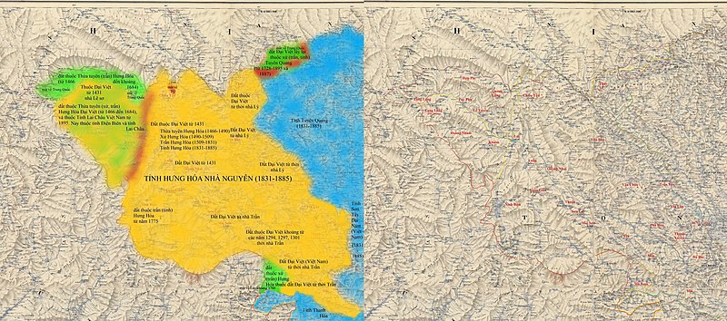
Tiếng Việt: Hưng Hóa với vị trí các địa danh châu huyện thuộc các phủ Quy Hóa, An Tây, Điện Biên, Gia Hưng của xứ Hưng Hóa tiếp giáp Trung Quốc, và Lào gôm (Văn Bàn, Thủy Vĩ, Chiêu Tấn, Quảng Lăng, Hợp Phì, Tuy Phụ, Hoàng Nham, Lễ Tuyền, Khiêm, Lai, Luân, Thuận, Tuần Giáo, Ninh Biên, Quỳnh Nhai, ...) |
| Date | |
| Source | Own work dựa trên tác phẩm đã thuộc phạm vi công cộng là https://commons.wikimedia.org/wiki/File:BacKy1902.jpg |
| Author | Doãn Hiệu |
Licensing[edit]
| I, the copyright holder of this work, release this work into the public domain. This applies worldwide. In some countries this may not be legally possible; if so: I grant anyone the right to use this work for any purpose, without any conditions, unless such conditions are required by law. |
File history
Click on a date/time to view the file as it appeared at that time.
| Date/Time | Thumbnail | Dimensions | User | Comment | |
|---|---|---|---|---|---|
| current | 23:16, 4 September 2018 | | 9,500 × 4,200 (22.46 MB) | Doãn Hiệu (talk | contribs) | Chỉnh lại biên giới đúng của Lào với tỉnh Thanh Hóa Việt Nam. |
| 14:27, 3 September 2018 |  | 9,500 × 4,200 (22.45 MB) | Doãn Hiệu (talk | contribs) | thêm niên đại lịch sử. | |
| 13:33, 3 September 2018 |  | 9,500 × 4,200 (22.4 MB) | Doãn Hiệu (talk | contribs) | Thêm các niên đại lịch sử. | |
| 10:55, 3 September 2018 |  | 9,500 × 4,200 (22.27 MB) | Doãn Hiệu (talk | contribs) | thêm bản tô màu. | |
| 06:27, 25 February 2018 |  | 4,750 × 4,200 (12.14 MB) | Doãn Hiệu (talk | contribs) | Thêm đường Biên giới Việt-Lào. | |
| 16:55, 22 February 2018 |  | 4,750 × 4,200 (12.11 MB) | Doãn Hiệu (talk | contribs) | Thêm địa danh và đường biên giới Bắc Kỳ-Trung Quốc năm 1890. | |
| 23:26, 22 January 2017 |  | 4,750 × 4,200 (12.07 MB) | Doãn Hiệu (talk | contribs) | User created page with UploadWizard |
You cannot overwrite this file.
File usage on Commons
There are no pages that use this file.
File usage on other wikis
The following other wikis use this file:
- Usage on vi.wikipedia.org
- Usage on zh.wikipedia.org