File:Houston Ship Channel Barbours Cut.jpg
Jump to navigation
Jump to search

Size of this preview: 800 × 534 pixels. Other resolutions: 320 × 214 pixels | 640 × 427 pixels | 1,024 × 683 pixels | 1,500 × 1,001 pixels.
Original file (1,500 × 1,001 pixels, file size: 693 KB, MIME type: image/jpeg)
Captions
Captions
Add a one-line explanation of what this file represents
| Description |
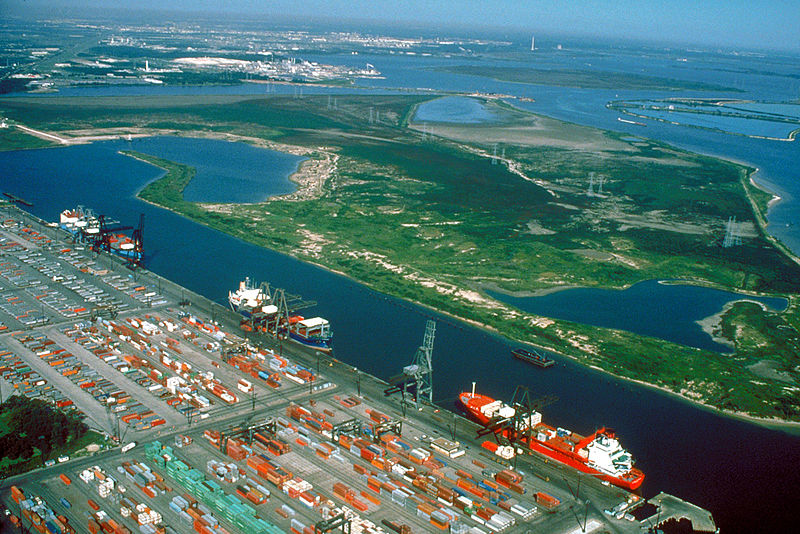
English: Aerial view of the Barbour's Cut area on the Houston Ship Channel in Houston, Texas, USA. This area is a large container terminal. This photograph appears to have been taken before the Fred Hartman Bridge was built, or when the bridge was under construction. In a present-day photograph, the bridge should be clearly visible at top right.
Coordinates: 29°40′54.98″N 94°59′54.37″W / 29.6819389°N 94.9984361°W |
|||
| Location | Houston, Texas, USA | |||
| Date | Probably pre-1995 | |||
| Source |
U.S. Army Corps of Engineers Digital Visual Library Image page Image description page Digital Visual Library home page |
|||
| Author | U.S. Army Corps of Engineers, photographer not specified or unknown | |||
| Permission (Reusing this file) |
|
File history
Click on a date/time to view the file as it appeared at that time.
| Date/Time | Thumbnail | Dimensions | User | Comment | |
|---|---|---|---|---|---|
| current | 01:22, 10 May 2007 | | 1,500 × 1,001 (693 KB) | DanMS (talk | contribs) | {{Information | Description = {{en|Aerial view of the Barbour's Cut area on the Houston Ship Channel in Houston, Texas, USA. This area is a large container terminal. This photograph appears to have been taken before the Fred Hartman Bridge was built, o |
You cannot overwrite this file.
File usage on Commons
The following 4 pages use this file:
File usage on other wikis
The following other wikis use this file:
- Usage on ar.wikipedia.org
- Usage on bn.wikipedia.org
- Usage on de.wikipedia.org
- Usage on en.wikipedia.org
- Usage on es.wikipedia.org
- Usage on eu.wikipedia.org
- Usage on fi.wikipedia.org
- Usage on fr.wikipedia.org
- Usage on gu.wikipedia.org
- Usage on hu.wikipedia.org
- Usage on it.wikipedia.org
- Usage on ja.wikipedia.org
- Usage on lt.wikipedia.org
- Usage on ml.wikipedia.org
- Usage on nl.wikipedia.org
- Usage on no.wikipedia.org
- Usage on pl.wikipedia.org
- Usage on pnb.wikipedia.org
- Usage on pt.wikipedia.org
- Usage on ru.wikipedia.org
- Usage on te.wikipedia.org
- Usage on tr.wikipedia.org
- Usage on uk.wikipedia.org
- Usage on ur.wikipedia.org
- Usage on uz.wikipedia.org
- Usage on vi.wikipedia.org
View more global usage of this file.