File:England and Wales population cartogram districts.svg
Jump to navigation
Jump to search

Size of this PNG preview of this SVG file: 525 × 599 pixels. Other resolutions: 210 × 240 pixels | 421 × 480 pixels | 673 × 768 pixels | 897 × 1,024 pixels | 1,795 × 2,048 pixels | 1,022 × 1,166 pixels.
Original file (SVG file, nominally 1,022 × 1,166 pixels, file size: 805 KB)
Captions
Captions
Add a one-line explanation of what this file represents
Summary[edit]
| Description |
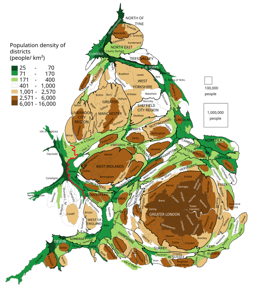
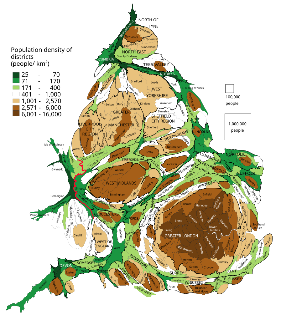
English: Population of districts. Their size shows their population, with some approximation, according to 2011 Census data. Each group of squares in the map key is 20 % of total number of districts.
Polski: Kartogram ludności Anglii i Walii. Liczba mieszkańców dystryktów. Wielkość dystryktów pokazuje liczbę jego mieszkańców, z pewnym przybliżeniem według danych z cenzusu z 2011. Każda grupa kwadratów w legendzie to 20 % liczby wszystkich dystryktów. |
| Date | |
| Source | Own work based on: population density from Population Estimates for UK, England and Wales, Scotland and Northern Ireland - Office for National Statistics, 2015 |
| Author | PawełS |
| SVG development |
Software:
- ScapeToad (First grid 1 600; Diffusion grid size 1024; 8 iterations)
- QGIS: Cartogram Creator plugin 10 iterations
Licensing[edit]
I, the copyright holder of this work, hereby publish it under the following license:
This file is licensed under the Creative Commons Attribution-Share Alike 3.0 Unported license.
- You are free:
- to share – to copy, distribute and transmit the work
- to remix – to adapt the work
- Under the following conditions:
- attribution – You must give appropriate credit, provide a link to the license, and indicate if changes were made. You may do so in any reasonable manner, but not in any way that suggests the licensor endorses you or your use.
- share alike – If you remix, transform, or build upon the material, you must distribute your contributions under the same or compatible license as the original.
File history
Click on a date/time to view the file as it appeared at that time.
| Date/Time | Thumbnail | Dimensions | User | Comment | |
|---|---|---|---|---|---|
| current | 17:14, 13 February 2019 | | 1,022 × 1,166 (805 KB) | PawełS (talk | contribs) | combined authorities |
| 21:08, 22 March 2017 |  | 1,022 × 1,166 (783 KB) | PawełS (talk | contribs) | Haringey and Devon font colour | |
| 14:34, 19 March 2017 |  | 1,022 × 1,166 (783 KB) | PawełS (talk | contribs) | + population density | |
| 18:01, 16 January 2014 |  | 1,024 × 1,188 (1 MB) | PawełS (talk | contribs) | Fonts size | |
| 17:49, 16 January 2014 |  | 1,024 × 1,188 (1.1 MB) | PawełS (talk | contribs) | Bold England-Wales border | |
| 20:01, 24 March 2013 |  | 1,024 × 1,188 (1.1 MB) | PawełS (talk | contribs) | Trying to fix fonts appearance in thumb | |
| 18:16, 14 March 2013 |  | 1,024 × 1,188 (1.1 MB) | PawełS (talk | contribs) | User created page with UploadWizard |
You cannot overwrite this file.
File usage on Commons
There are no pages that use this file.
File usage on other wikis
The following other wikis use this file:
- Usage on en.wikipedia.org
- Usage on is.wikipedia.org
- Usage on ku.wikipedia.org
- Usage on pl.wikipedia.org
- Usage on vi.wikipedia.org