File:China1136.png
Jump to navigation
Jump to search

Size of this preview: 799 × 189 pixels. Other resolutions: 320 × 76 pixels | 640 × 151 pixels | 1,024 × 242 pixels | 1,280 × 303 pixels | 5,190 × 1,228 pixels.
Original file (5,190 × 1,228 pixels, file size: 9.81 MB, MIME type: image/png)
Captions
Captions
Add a one-line explanation of what this file represents
Info[edit]
| Description |
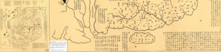
Tiếng Việt: Bản đồ Cực nam Trung Hoa, trích từ bản đồ in dập khắc đá "Hua Yi Tu" 1136, xuất bẩn ở Pháp năm 1903, Chính phủ Philippin sao lại từ bản kỹ thuật số trong thư viện Quốc hội Hoa Kỳ (Catalogue No.2002626771; ID kỹ thuật số g7820 ct000284).
Bản đồ này cho thấy đảo Hải Nam là cực nam của lãnh thổ Trung Quốc. (Các chú thích trên các cạnh của bản đồ này không phải là một phần của việc khắc đá.) 19(驩州,日南,即越裳,林邑之地漢。馬援植銅柱以表漢界。宋,自開寳以來,交趾修貢請内附,皆受封爵焉。/Hoan Châu, Nhật Nam tức Việt Thường, Lâm Ấp chi địa Hán. Mã Viện thực đồng trụ dĩ biểu Hán giới. Tống tự khai bảo dĩ lai, Giao Chỉ tu cống, thỉnh nội phụ, giai thụ phong tước yên./Hoan Châu, Nhật Nam tức Việt Thường, Lâm Ấp là đất nhà Hán. Mã Viện dựng trụ đồng lấy làm biên giới nhà Hán. Nhà Tống, từ năm Khai Bảo đến nay, Giao Chỉ thuận cống, thỉnh cầu quy phụ, đồng thời nhận phong tước.) 20(海南之國。扶南丹丹,尤論,訶陵。闍婆投和,于坨利,..。羅利,諸..,林邑,..。Hải Nam chi quốc. Phù Nam đan đan, vưu luận, kha lăng. Đồ Bà đầu hòa, vu đà lợi,... La lợi, chư..., Lâm Ấp,... ) 21(五嶺,自衡山,之南一山,東盡于海。其南漲海,之北古荒服,秦置三郡。漢分九郡,日南,朱崖,皆其地。/Ngũ Lĩnh, tự Hoành Sơn, chi nam nhất sơn, đông tận vu hải. Kì nam Trướng Hải, chi bắc cổ hoang phục, Tần trí tam quận. Hán phân cửu quận, Nhật Nam, Chu Nhai, giai kì địa.) |
|||||
| Date | ||||||
| Source | http://www.imoa.ph/imoawebexhibit/ | |||||
| Author | Khuyết danh thời nhà Tống | |||||
| Permission (Reusing this file) |
|
|||||
| Other versions |
|
|||||


File history
Click on a date/time to view the file as it appeared at that time.
| Date/Time | Thumbnail | Dimensions | User | Comment | |
|---|---|---|---|---|---|
| current | 09:05, 11 July 2014 | 5,190 × 1,228 (9.81 MB) | Doãn Hiệu (talk | contribs) | {{Information |Description ={{vi|1=Bản đồ Cực nam Trung Hoa, trích từ bản đồ in dập khắc đá "Hua Yi Tu" 1136, xuất bẩn ở Pháp năm 1903, Chính phủ Philippin sao lại từ bản kỹ thuật số trong thư viện Qu�... |
You cannot overwrite this file.
File usage on Commons
The following 2 pages use this file:
File usage on other wikis
The following other wikis use this file:
- Usage on vi.wikipedia.org