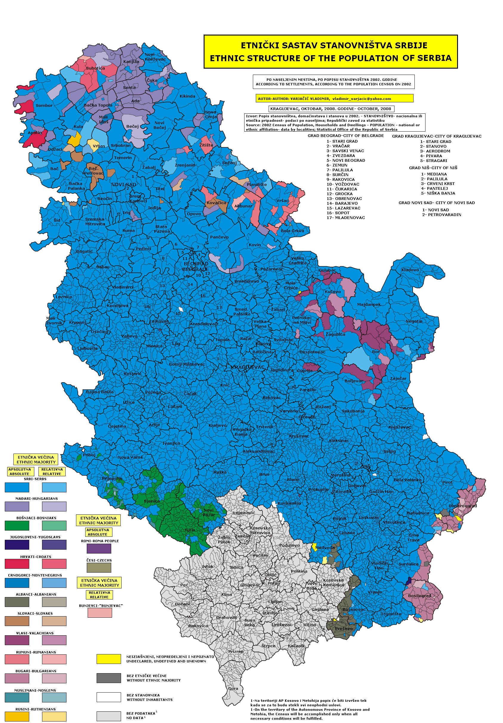
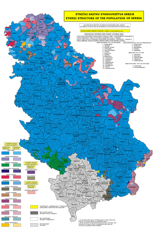
File:Census 2002 Serbia, ethnic map (by localities).png
Jump to navigation
Jump to search
Size of this preview: 417 × 599 pixels. Other resolutions: 167 × 240 pixels | 334 × 480 pixels | 535 × 768 pixels | 713 × 1,024 pixels | 1,687 × 2,423 pixels.
Original file (1,687 × 2,423 pixels, file size: 1.45 MB, MIME type: image/png)
Captions
Captions
Add a one-line explanation of what this file represents
Summary[edit]
.png&action=edit§ion=1)
- English: Ethnic map of Serbia - census 2002 - data by settlements.
- Serbian: Etnička mapa Srbije - popis iz 2002 - podaci po naseljima.
Source and licence[edit]
.png&action=edit§ion=2)
author of the map is user Варја (Varjačić Vladimir) from Serbian Wikipedia, file was moved from Serbian Wikipedia to Wikimedia Commons by user PANONIAN (User:PANONIAN is not author of this map).
original source file: http://sr.wikipedia.org/wiki/Слика:Census_2002_Serbia,_ethnic_map_(by_localities).png
.png)
author of the map: http://sr.wikipedia.org/wiki/Корисник:Варја

|
Permission is granted to copy, distribute and/or modify this document under the terms of the GNU Free Documentation License, Version 1.2 or any later version published by the Free Software Foundation; with no Invariant Sections, no Front-Cover Texts, and no Back-Cover Texts. A copy of the license is included in the section entitled GNU Free Documentation License. |
This file is licensed under the Creative Commons Attribution 3.0 Serbia license.
Attribution: Varjačić Vladimir
- You are free:
- to share – to copy, distribute and transmit the work
- to remix – to adapt the work
- Under the following conditions:
- attribution – You must give appropriate credit, provide a link to the license, and indicate if changes were made. You may do so in any reasonable manner, but not in any way that suggests the licensor endorses you or your use.

References[edit]
.png&action=edit§ion=3)
- Popis stanovništva, domaćinstava i stanova u 2002, Stanovništvo, knjiga 1, Nacionalna ili etnička pripadnost - podaci po naseljima, Republika Srbija, Republički zavod za statistiku, Beograd, februar 2003.

|
This ethnographic map image could be re-created using vector graphics as an SVG file. This has several advantages; see Commons:Media for cleanup for more information. If an SVG form of this image is available, please upload it and afterwards replace this template with
{{vector version available|new image name}}.
It is recommended to name the SVG file “Census 2002 Serbia, ethnic map (by localities).svg”—then the template Vector version available (or Vva) does not need the new image name parameter. |
File history
Click on a date/time to view the file as it appeared at that time.
| Date/Time | Thumbnail | Dimensions | User | Comment | |
|---|---|---|---|---|---|
| current | 16:14, 15 December 2009 | | 1,687 × 2,423 (1.45 MB) | PANONIAN (talk | contribs) | corrected census data for Novi Žednik and Stari Žednik in Subotica municipality |
| 09:39, 10 February 2009 |  | 1,687 × 2,423 (1.01 MB) | PANONIAN (talk | contribs) | Ethnic map of Serbia - census 2002. author of the map is user Варја (Varjačić Vladimir) from Serbian Wikipedia, file was moved from Serbian Wikipedia to Wikimedia Commons by user PANONIAN. original source file: http://sr.wikipedia.org/wiki/Сли |
You cannot overwrite this file.
File usage on Commons
The following page uses this file:
File usage on other wikis
The following other wikis use this file:
- Usage on bg.wikipedia.org
- Usage on cs.wikipedia.org
- Usage on de.wikipedia.org
- Usage on en.wikipedia.org
- Usage on es.wikipedia.org
- Usage on fr.wikipedia.org
- Usage on gl.wikipedia.org
- Usage on hr.wikipedia.org
- Usage on it.wikipedia.org
- Usage on krc.wikipedia.org
- Usage on lt.wikipedia.org
- Usage on ro.wikipedia.org
- Usage on ru.wikipedia.org
- Usage on sh.wikipedia.org
- Usage on sq.wikipedia.org
- Usage on sr.wikipedia.org
- Usage on vi.wikipedia.org
.png&oldid=852443588)