File:Caucasus region 1994.jpg
Jump to navigation
Jump to search

Size of this preview: 782 × 600 pixels. Other resolutions: 313 × 240 pixels | 626 × 480 pixels | 1,002 × 768 pixels | 1,280 × 982 pixels | 2,560 × 1,963 pixels | 3,119 × 2,392 pixels.
Original file (3,119 × 2,392 pixels, file size: 1.18 MB, MIME type: image/jpeg)
Captions
Captions
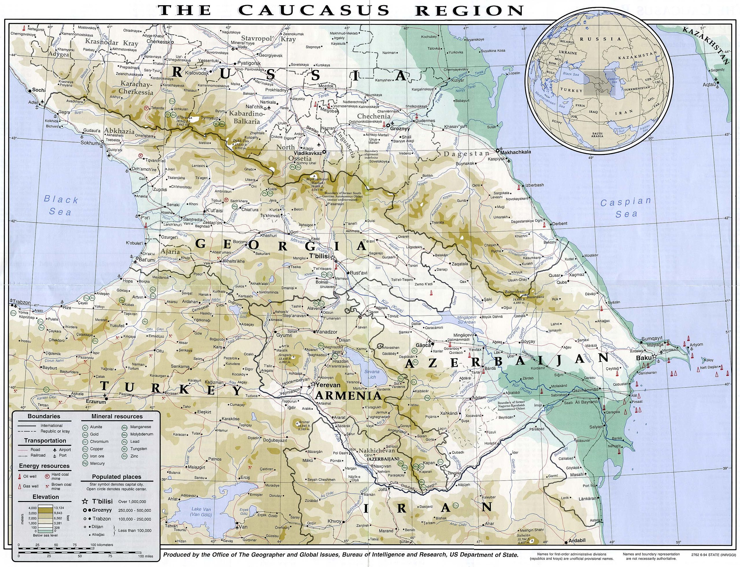
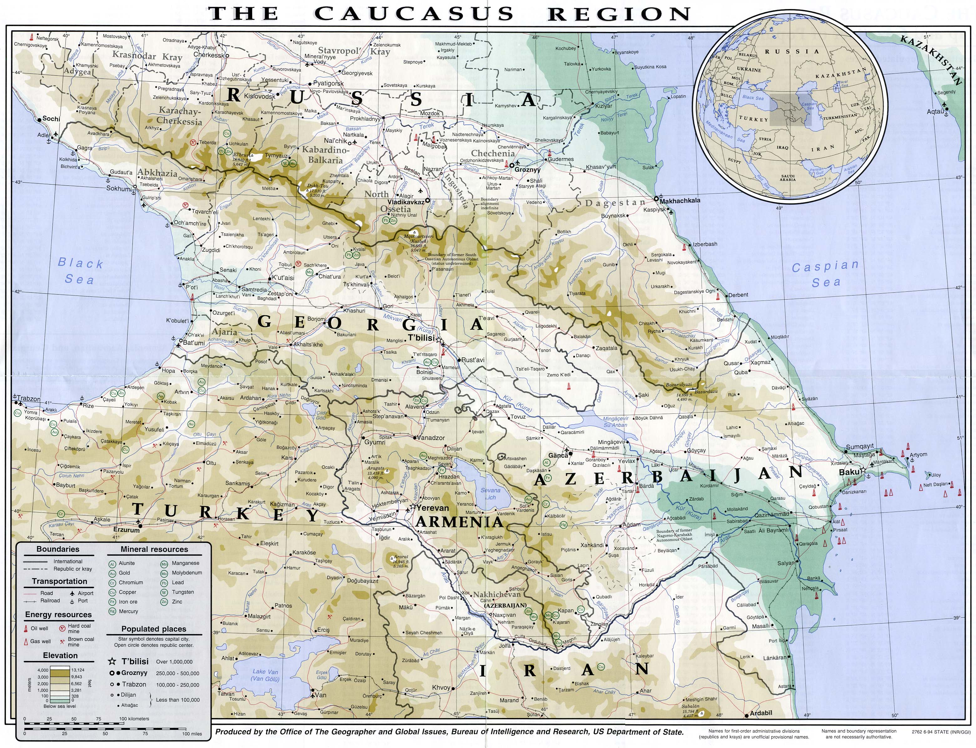
1994 map of Transcaucasia and surrounding areas.
| Description |
English: Map of the Caucasus region in 1994
Français : Carte du Caucase en 1994 |
|||
| Date | ||||
| Source | University of Texas Library | |||
| Author | CIA | |||
| Permission (Reusing this file) |
|
|||
| Other versions |


File history
Click on a date/time to view the file as it appeared at that time.
| Date/Time | Thumbnail | Dimensions | User | Comment | |
|---|---|---|---|---|---|
| current | 14:49, 16 July 2007 | | 3,119 × 2,392 (1.18 MB) | Pmx (talk | contribs) | {{Information |Description= {{en|Map of the Caucasus region in 1994}} {{fr|Carte du Caucase en 1994}} |Source=University of Texas Library [http://www.lib.utexas.edu/maps/commonwealth/caucasus_region_1994.jpg] |Date=1994 |Author=CIA |Permission=Public doma |
You cannot overwrite this file.
File usage on Commons
The following 10 pages use this file:
File usage on other wikis
The following other wikis use this file:
- Usage on ar.wikipedia.org
- Usage on arz.wikipedia.org
- Usage on ast.wikipedia.org
- Usage on azb.wikipedia.org
- Usage on az.wikipedia.org
- Usage on ba.wikipedia.org
- Usage on bg.wikipedia.org
- Usage on bh.wikipedia.org
- Usage on bs.wikipedia.org
- Usage on ca.wikipedia.org
- Usage on de.wikivoyage.org
- Usage on en.wikipedia.org
- Usage on eo.wikipedia.org
- Usage on eu.wikipedia.org
- Usage on fr.wikipedia.org
- Usage on ga.wikipedia.org
- Usage on he.wikipedia.org
- Usage on hif.wikipedia.org
- Usage on hr.wikipedia.org
- Usage on hu.wikipedia.org
- Usage on id.wikipedia.org
- Usage on it.wikipedia.org
- Usage on it.wikivoyage.org
- Usage on kk.wikipedia.org
- Usage on ko.wikipedia.org
- Usage on ku.wikipedia.org
- Usage on lv.wikipedia.org
- Usage on ml.wikipedia.org
- Usage on ms.wikipedia.org
- Usage on pnb.wikipedia.org
- Usage on pt.wikipedia.org
- Usage on ro.wikipedia.org
- Usage on sl.wikipedia.org
- Usage on so.wikipedia.org
- Usage on su.wikipedia.org
- Usage on sv.wikivoyage.org
- Usage on ta.wikipedia.org
- Usage on tg.wikipedia.org
View more global usage of this file.