File:Georgia topographic map-fr.svg
Jump to navigation
Jump to search

Size of this PNG preview of this SVG file: 707 × 385 pixels. Other resolutions: 320 × 174 pixels | 640 × 349 pixels | 1,024 × 558 pixels | 1,280 × 697 pixels | 2,560 × 1,394 pixels.
Original file (SVG file, nominally 707 × 385 pixels, file size: 3.52 MB)
Captions
Captions
Add a one-line explanation of what this file represents
Summary[edit]
| Description |
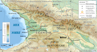
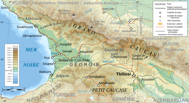
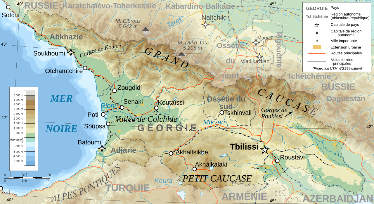
Deutsch: Topographische Karte von Georgien, französische Version English: Topographic map in French of Georgia Français : Carte topographique en français de la Géorgie |
| Date | |
| Source |
English: Own work ; Topographic data from the NASA Shuttle Radar Topography Mission (SRTM3 v.2) (public domain) edited with 3DEM, reprojected in UTM with GDAL (GDAL), and vectorized with Inkscape ; UTM projection ; WGS84 datum ; shaded relief (composite image of N-W, W and N lightning positions) ; Reference used for the additional data : * Rivers, cities, railroads, routes, bathymetry : Demis add-on for World Wind (see the approval e-mail and the Demis forum) ; * Borders and coast : World data bank II ; Approximate scale of topographic data : 1:1,463,000 ; Note : The shaded relief is a raster image embedded in the SVG file. Français : Création personnelle ; Données topographiques de la NASA Shuttle Radar Topography Mission (SRTM3 v.2) (domaine public) éditées avec 3DEM, reprojetées en UTM avec GDAL et vectorisées avec Inkscape ; projection UTM ; WGS84 datum ; relief ombré (image composite d'éclairages du N-O, O et N) ; Références utilisées pour les données complémentaires : * Rivières, villes, chemins de fers, routes, bathymétrie : Demis add-on for World Wind (cf. l'e-mail d'approbation de Demis et le Demis forum) ; * Frontières et côtes : World data bank II ; Échelle approximative des données topographiques : 1:1 463 000 ; Note : Le relief ombré est une image bitmap embarquée dans le fichier SVG. |
| Author | Bourrichon - fr:Bourrichon |
| Permission (Reusing this file) |
GFDL / Attribution and Share-Alike required |
| Other versions |
Derivative works of this file: Georgia topographic map-blanked.svg
|


|
This SVG file contains embedded text that can be translated into your language, using any capable SVG editor, text editor or the SVG Translate tool. For more information see: About translating SVG files. |
Licensing[edit]
I, the copyright holder of this work, hereby publish it under the following licenses:

|
Permission is granted to copy, distribute and/or modify this document under the terms of the GNU Free Documentation License, Version 1.2 or any later version published by the Free Software Foundation; with no Invariant Sections, no Front-Cover Texts, and no Back-Cover Texts. A copy of the license is included in the section entitled GNU Free Documentation License. |
This file is licensed under the Creative Commons Attribution-Share Alike 4.0 International, 3.0 Unported, 2.5 Generic, 2.0 Generic and 1.0 Generic license.
- You are free:
- to share – to copy, distribute and transmit the work
- to remix – to adapt the work
- Under the following conditions:
- attribution – You must give appropriate credit, provide a link to the license, and indicate if changes were made. You may do so in any reasonable manner, but not in any way that suggests the licensor endorses you or your use.
- share alike – If you remix, transform, or build upon the material, you must distribute your contributions under the same or compatible license as the original.
You may select the license of your choice.
File history
Click on a date/time to view the file as it appeared at that time.
| Date/Time | Thumbnail | Dimensions | User | Comment | |
|---|---|---|---|---|---|
| current | 14:57, 13 January 2020 | | 707 × 385 (3.52 MB) | Takhirgeran Umar (talk | contribs) | clarification |
| 21:43, 30 March 2009 |  | 707 × 385 (3.52 MB) | Bourrichon (talk | contribs) | +Daguestan | |
| 18:09, 13 March 2009 |  | 707 × 385 (3.52 MB) | Bourrichon (talk | contribs) | + longitude | |
| 18:01, 13 March 2009 |  | 707 × 385 (3.52 MB) | Bourrichon (talk | contribs) | -Iran | |
| 17:38, 13 March 2009 |  | 707 × 385 (4.55 MB) | Bourrichon (talk | contribs) | + Gorges | |
| 17:32, 13 March 2009 |  | 707 × 385 (4.52 MB) | Bourrichon (talk | contribs) | == Summary == {{Information |Description={{de|Topographische Karte von Georgien, französische Version}}{{en|Topographic map in French of Georgia}}{{fr|Carte topographique en français de la [[:fr:Géorgie (pays)|Géorgie] |
You cannot overwrite this file.
File usage on Commons
The following 5 pages use this file:
File usage on other wikis
The following other wikis use this file:
- Usage on ab.wikipedia.org
- Usage on cv.wikipedia.org
- Usage on fr.wikipedia.org
- Géorgie (pays)
- Géographie de la Géorgie
- Projet:Cartographie/Cartes standards/Pays
- Wikipédia:Atelier graphique/Cartes/Archives/mars 2009
- Wikipédia:Atelier graphique/Cartes/Archives/avril 2009
- Wikipédia:Atelier graphique/Cartes/Archives/Demandes mises en sommeil/Europe
- Liste des villes jumelées de Géorgie
- Usage on ht.wikipedia.org
- Usage on uz.wikipedia.org
- Usage on wo.wikipedia.org