File:Saint Petersburg 1776 map LOC g7064s ct001468.jpg
Jump to navigation
Jump to search

Size of this preview: 800 × 511 pixels. Other resolutions: 320 × 204 pixels | 640 × 409 pixels | 1,024 × 654 pixels | 1,280 × 818 pixels | 2,560 × 1,635 pixels | 8,328 × 5,320 pixels.
Original file (8,328 × 5,320 pixels, file size: 6.99 MB, MIME type: image/jpeg)
Captions
Captions
Add a one-line explanation of what this file represents
| Description |
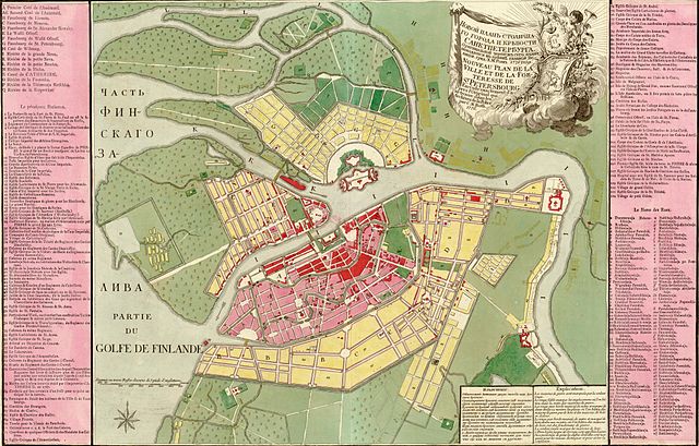
Русский: Novoi plan stolichnago goroda i krieposti Sanktpeterburga. Grid: Kh. M. Rot. Français : Nouveau plan de la ville et de la forteresse de St. Pétersbourg, exécuté exactement d'apres l'original qui se trouve dans les archives de la Police. Par C. M. Roth. English: New Map of the city and the fortress of St Petersburg, drawn exactly according to the original file in the archives of the Police. By C.M. Roth. |
||||
| Date | |||||
| Source | Library of Congress Geography and Map Division Washington; http://memory.loc.gov/ammem/gmdhtml/gmdhome.html | ||||
| Author | C. M. Roth. | ||||
| Permission (Reusing this file) |
|
||||
| Other versions |
 |
||||

|
This map is available from the United States Library of Congress's Geography & Map Division
under the digital ID g7064s.ct001468. This tag does not indicate the copyright status of the attached work. A normal copyright tag is still required. See Commons:Licensing.
|
File history
Click on a date/time to view the file as it appeared at that time.
| Date/Time | Thumbnail | Dimensions | User | Comment | |
|---|---|---|---|---|---|
| current | 05:49, 9 November 2006 | | 8,328 × 5,320 (6.99 MB) | Balcer~commonswiki (talk | contribs) | Novoi plan stolichnago goroda i krieposti Sanktpeterburga. Nouveau plan de la ville et de la forteresse de St. Pétersbourg. Grid: Kh. M. Rot. Par C. M. Roth. Published in 1776. {{PD-LOC}} {{LOC-image|id=g7064s.ct001468 }} |
You cannot overwrite this file.
File usage on Commons
The following 3 pages use this file:
File usage on other wikis
The following other wikis use this file:
- Usage on bo.wikipedia.org
- Usage on fi.wikipedia.org
- Usage on fr.wikipedia.org
- Usage on gl.wikipedia.org
- Usage on ka.wikipedia.org
- Usage on pl.wikipedia.org
- Usage on ru.wikipedia.org
- Usage on uk.wikipedia.org