File:Median Empire uk.svg
Jump to navigation
Jump to search

Size of this PNG preview of this SVG file: 800 × 507 pixels. Other resolutions: 320 × 203 pixels | 640 × 405 pixels | 1,024 × 649 pixels | 1,280 × 811 pixels | 2,560 × 1,621 pixels | 1,500 × 950 pixels.
Original file (SVG file, nominally 1,500 × 950 pixels, file size: 1.78 MB)
Captions
Captions
Add a one-line explanation of what this file represents
Summary[edit]
| Description |
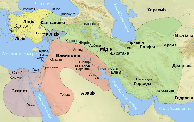
English: Map of Median Empire, Egypt, Lydian Empire and Neo-Babyloninan Empire, VI century BC. Created with Generic Mapping Tools, Gimp and Inkscape. Used ETOPO1 topographic data from NGDC (http://www.ngdc.noaa.gov/mgg/global/global.html)
Українська: Лідія, Єгипет, Мідія та Нововасилонське царство до часу створення Імперії Ахеменідів |
| Date | |
| Source | File:Median_Empire_ru.svg |
| Author | Anton Gutsunaev |
| Other versions |
[] |


Licensing[edit]
This file is licensed under the Creative Commons Attribution-Share Alike 3.0 Unported license.
- You are free:
- to share – to copy, distribute and transmit the work
- to remix – to adapt the work
- Under the following conditions:
- attribution – You must give appropriate credit, provide a link to the license, and indicate if changes were made. You may do so in any reasonable manner, but not in any way that suggests the licensor endorses you or your use.
- share alike – If you remix, transform, or build upon the material, you must distribute your contributions under the same or compatible license as the original.
File history
Click on a date/time to view the file as it appeared at that time.
| Date/Time | Thumbnail | Dimensions | User | Comment | |
|---|---|---|---|---|---|
| current | 11:00, 17 September 2010 | | 1,500 × 950 (1.78 MB) | Erud (talk | contribs) | {{Information |Description={{en|1={{en|1=Map of Median Empire, Egypt, Lydian Empire and Neo-Babyloninan Empire, VI century BC. Created with Generic Mapping Tools, Gimp |
You cannot overwrite this file.
File usage on Commons
The following 12 pages use this file:
- File:Median Empire-ar.svg
- File:Median Empire-de.png
- File:Median Empire-de.svg
- File:Median Empire-en.svg
- File:Median Empire-es.svg
- File:Median Empire-hu.svg
- File:Median Empire-pt.svg
- File:Median Empire ce.svg
- File:Median Empire ru.svg
- File:Median Empire sr.svg
- File:Median Empire uk.svg
- Template:Other versions/Median Empire
File usage on other wikis
The following other wikis use this file:
- Usage on uk.wikipedia.org