File:España-Canarias-loc.svg
Jump to navigation
Jump to search

Size of this PNG preview of this SVG file: 512 × 462 pixels. Other resolutions: 266 × 240 pixels | 532 × 480 pixels | 851 × 768 pixels | 1,135 × 1,024 pixels | 2,270 × 2,048 pixels.
Original file (SVG file, nominally 512 × 462 pixels, file size: 919 KB)
Captions
Captions
Add a one-line explanation of what this file represents
Summary[edit]
| Description |
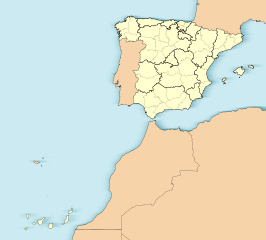
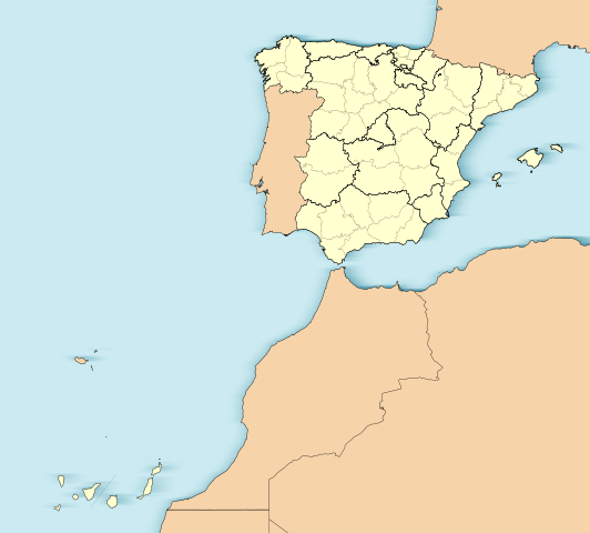
English: Location map of Spain with the Canary Islands
Equirectangular projection, N/S stretching 130 %. Geographic limits of the map:
Español: Mapa de localización de España con la Islas Canarias
Proyección equirrectangular (cilíndrica equidistante), N/S estirada 130 %. Límites geográficos del mapa:
|
|
| Date | ||
| Source | Own work based on: EspañaLoc.svg | |
| Author | Miguillen | |
| SVG development | This W3C-invalid locator map was created with Adobe Illustrator.
|
Licensing[edit]
Miguillen, the copyright holder of this work, hereby publishes it under the following license:
This file is licensed under the Creative Commons Attribution-Share Alike 3.0 Unported license.
Attribution: Miguillen
- You are free:
- to share – to copy, distribute and transmit the work
- to remix – to adapt the work
- Under the following conditions:
- attribution – You must give appropriate credit, provide a link to the license, and indicate if changes were made. You may do so in any reasonable manner, but not in any way that suggests the licensor endorses you or your use.
- share alike – If you remix, transform, or build upon the material, you must distribute your contributions under the same or compatible license as the original.
File history
Click on a date/time to view the file as it appeared at that time.
| Date/Time | Thumbnail | Dimensions | User | Comment | |
|---|---|---|---|---|---|
| current | 15:31, 3 June 2012 | | 512 × 462 (919 KB) | Miguillen (talk | contribs) | Quito isla inexistente en el golfo de Cádiz y retiro margen externo. |
| 12:45, 18 November 2010 |  | 512 × 462 (932 KB) | Miguillen (talk | contribs) | me he equivocado de archivo | |
| 12:44, 18 November 2010 |  | 512 × 398 (2.82 MB) | Miguillen (talk | contribs) | == {{int:filedesc}} == {{Information |Description={{en|Location map of Spain}} Equirectangular projection, N/S stretching 130 %. Geographic limits of the map: * N: ° N * S: ° N * W: ° O * E: ° O {{es|Mapa de localización de [[:es:E |
You cannot overwrite this file.
File usage on Commons
The following 41 pages use this file:
- File:Andalucia in Spain.svg
- File:Andalucia in Spain (including Canarias) (special marker).svg
- File:Andalucia in Spain (plus Canarias).svg
- File:Andalucia in Spain (special marker).svg
- File:Aragon in Spain.svg
- File:Aragon in Spain (including Canarias).svg
- File:Asturias in Spain.svg
- File:Asturias in Spain (including Canarias).svg
- File:Cantabria in Spain.svg
- File:Cantabria in Spain (including Canarias).svg
- File:Castilla-La Mancha in Spain.svg
- File:Castilla-La Mancha in Spain (plus Canarias).svg
- File:Castilla y Leon in Spain.svg
- File:Castilla y Leon in Spain (including Canarias).svg
- File:Cataluna in Spain.svg
- File:Cataluna in Spain (including Canarias).svg
- File:Ceuta in Spain.svg
- File:Ceuta in Spain (including Canarias).svg
- File:Comunidad Valenciana in Spain.svg
- File:Comunidad Valenciana in Spain (including Canarias).svg
- File:Comunidad de Madrid in Spain.svg
- File:Comunidad de Madrid in Spain (including Canarias).svg
- File:Emblem of the Spanish Air Force Cartographic and Photographic Centre.svg
- File:Extremadura in Spain.svg
- File:Extremadura in Spain (including Canarias).svg
- File:Galicia in Spain.svg
- File:Galicia in Spain (including Canarias).svg
- File:Islas Baleares in Spain.svg
- File:Islas Baleares in Spain (including Canarias).svg
- File:Islas Canarias (real location) in Spain.svg
- File:Islas Canarias in Spain.svg
- File:La Rioja in Spain.svg
- File:La Rioja in Spain (including Canarias).svg
- File:Melilla in Spain.svg
- File:Melilla in Spain (including Canarias).svg
- File:Navarra in Spain.svg
- File:Navarra in Spain (including Canarias).svg
- File:Pais Vasco in Spain.svg
- File:Pais Vasco in Spain (including Canarias).svg
- File:Region de Murcia in Spain.svg
- File:Region de Murcia in Spain (including Canarias).svg
_(special_marker).svg)
.svg)
.svg)
.svg)
.svg)
.svg)
.svg)
.svg)
.svg)
.svg)
.svg)
.svg)
.svg)
.svg)
.svg)
_in_Spain.svg)
.svg)
.svg)
.svg)
.svg)
.svg)
File usage on other wikis
The following other wikis use this file:
- Usage on ar.wikipedia.org
- Usage on ast.wikipedia.org
- Mallorca
- Península Ibérica
- Bermellar
- Saldeana
- Estorga
- Santiago de Compostela
- Melilla
- Ceuta
- Ríu Duero
- Ríu Esla
- Aldeadávila de la Ribera
- Masueco
- Vilvestre
- Lumbrales
- Pereña de la Ribera
- Bermillo de Sayago
- Fermoselle
- Alcañices
- Ciudad Rodrigo
- Salamanca
- Llión
- Zamora
- Albacete
- A Ponte de Domingos Flórez
- Alija del Infantado
- Toral de los Vados
- Santovenia de la Valdoncina
- Acebedo (Lleón)
- Algadefe
- Almanza
- Castrocontrigo
- Ríu Eria
- Teleno
- Ozaniego
- La Nora del Río
- Navianos de la Vega
- Cabrera de Almanza
- Calaveras de Abajo
- Calaveras de Arriba
- Castromudarra
- Espinosa de Almanza
- La Vega de Almanza
- Toreno
- Barcelona
- Ríu Órbigu
- Ríu Tuerto
- Zaragoza
- Logroño
- Ríu Deva
View more global usage of this file.