File:Australian oil and gas facilities map-en.svg
Jump to navigation
Jump to search

Size of this PNG preview of this SVG file: 800 × 564 pixels. Other resolutions: 320 × 226 pixels | 640 × 451 pixels | 1,024 × 722 pixels | 1,280 × 902 pixels | 2,560 × 1,805 pixels | 1,146 × 808 pixels.
Original file (SVG file, nominally 1,146 × 808 pixels, file size: 224 KB)
Captions
Captions
Add a one-line explanation of what this file represents
Summary[edit]
| Description |
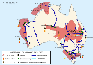
English: Australian oil and gas facilities map. Français : Carte de la répartition du pétrole et du gaz naturel en Australie. |
| Date | |
| Source | Own work based on: Australian Government Department of Resources, Energy and Tourism 2008 report + Oil drop.svg by Slashme |
| Author | Historicair |
| Other versions |
[]
|
| SVG development |


Licensing[edit]
I, the copyright holder of this work, hereby publish it under the following license:
This file is licensed under the Creative Commons Attribution-Share Alike 3.0 Unported license.
- You are free:
- to share – to copy, distribute and transmit the work
- to remix – to adapt the work
- Under the following conditions:
- attribution – You must give appropriate credit, provide a link to the license, and indicate if changes were made. You may do so in any reasonable manner, but not in any way that suggests the licensor endorses you or your use.
- share alike – If you remix, transform, or build upon the material, you must distribute your contributions under the same or compatible license as the original.
File history
Click on a date/time to view the file as it appeared at that time.
| Date/Time | Thumbnail | Dimensions | User | Comment | |
|---|---|---|---|---|---|
| current | 17:19, 11 June 2011 | | 1,146 × 808 (224 KB) | Historicair (talk | contribs) |
You cannot overwrite this file.
File usage on Commons
The following 3 pages use this file:
File usage on other wikis
The following other wikis use this file:
- Usage on ar.wikipedia.org
- Usage on en.wikipedia.org
- Usage on fr.wikipedia.org
- Usage on uk.wikipedia.org