File:Serbia022 02.png
Jump to navigation
Jump to search

Size of this preview: 450 × 599 pixels. Other resolutions: 180 × 240 pixels | 361 × 480 pixels | 577 × 768 pixels | 1,100 × 1,464 pixels.
Original file (1,100 × 1,464 pixels, file size: 181 KB, MIME type: image/png)
Captions
Captions
Add a one-line explanation of what this file represents
Summary[edit]
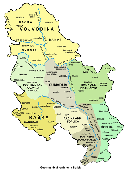
| Description | Map of geographical regions in Serbia (version without Kosovo). |
| Date | |
| Source | Own work |
| Author | PANONIAN |
Licensing[edit]
I, the copyright holder of this work, hereby publish it under the following license:
| This file is made available under the Creative Commons CC0 1.0 Universal Public Domain Dedication. | |
| The person who associated a work with this deed has dedicated the work to the public domain by waiving all of their rights to the work worldwide under copyright law, including all related and neighboring rights, to the extent allowed by law. You can copy, modify, distribute and perform the work, even for commercial purposes, all without asking permission.
|
References[edit]
- Milovan Radovanović, Kosovo i Metohija - antropogeografske, istorijskogeografske, demografske i geopolitičke osnove, Službeni glasnik, Beograd, 2008.
- Miodrag Milošević, Geografija za 8. razred osnovne škole, Zavod za udžbenike i nastavna sredstva, Beograd, 1994.
- Denis Šehić - Demir Šehić, Geografski atlas Srbije, Beograd, 2007.
- Aleksandar B. Milojković - Goran M. Jovanović, Školski geografski atlas, Intersistem kartografija, Beograd, 2001.
- Slobodan Radovanović, Geografski atlas, Magic Map, Smederevska Palanka, 2001.
- Goran Jovanović, Geografski atlas, Intersistem kartografija, Beograd, 2004.
- Zorica Grujić-Kiš - Marko Stevanović, Geografski atlas za peti, šesti, sedmi i osmi razred osnovne škole, Geokarta, Beograd, 2002.
- Ljiljana Popović - Vlado Jarčov, Geografski atlas sveta, Beograd, 2002.
File history
Click on a date/time to view the file as it appeared at that time.
| Date/Time | Thumbnail | Dimensions | User | Comment | |
|---|---|---|---|---|---|
| current | 17:08, 29 May 2012 | | 1,100 × 1,464 (181 KB) | PANONIAN (talk | contribs) | {{Information |Description=Map of geographical regions in Serbia (version without Kosovo). |Source={{own}} |Date=2012 |Author= PANONIAN |Permission= |other_versions= }} |
You cannot overwrite this file.
File usage on Commons
The following page uses this file:
File usage on other wikis
The following other wikis use this file:
- Usage on ast.wikipedia.org
- Usage on be.wikipedia.org
- Usage on bg.wikipedia.org
- Usage on de.wikipedia.org
- Usage on es.wikipedia.org
- Usage on fa.wikipedia.org
- Usage on hr.wikipedia.org
- Usage on it.wikipedia.org
- Usage on lt.wikipedia.org
- Usage on mk.wikipedia.org
- Usage on ms.wikipedia.org
- Usage on nn.wikipedia.org
- Usage on no.wikipedia.org
- Usage on pl.wikipedia.org
- Usage on sq.wikipedia.org
- Usage on tt.wikipedia.org
- Usage on uk.wikipedia.org
- Usage on zh.wikipedia.org