File:Greater Helsinki Urban Area.svg
Jump to navigation
Jump to search

Size of this PNG preview of this SVG file: 727 × 600 pixels. Other resolutions: 291 × 240 pixels | 582 × 480 pixels | 931 × 768 pixels | 1,242 × 1,024 pixels | 2,484 × 2,048 pixels | 1,323 × 1,091 pixels.
Original file (SVG file, nominally 1,323 × 1,091 pixels, file size: 1.72 MB)
Captions
Captions
Add a one-line explanation of what this file represents

Summary[edit]
| Description |
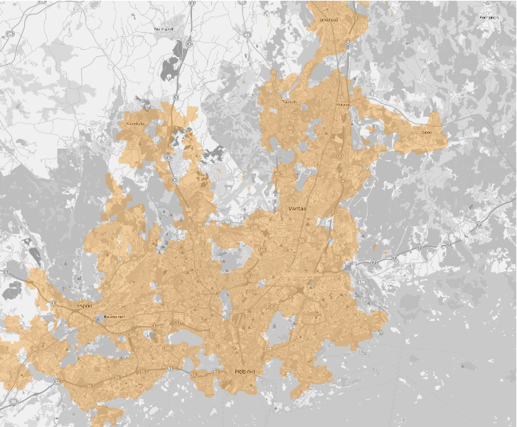
English: continuous urban area based around Helsinki Suomi: Helsingin kaupunkiseudun keskustaajama Suomen ympäristöhallinnon määrittelemänä kaupunkiseutujen rajauksena (vuodelta 2010). |
| Date | |
| Source |
|
| Author |
|
Licensing[edit]
I, the copyright holder of this work, hereby publish it under the following license:
This file is licensed under the Creative Commons Attribution-Share Alike 3.0 Unported license.
- You are free:
- to share – to copy, distribute and transmit the work
- to remix – to adapt the work
- Under the following conditions:
- attribution – You must give appropriate credit, provide a link to the license, and indicate if changes were made. You may do so in any reasonable manner, but not in any way that suggests the licensor endorses you or your use.
- share alike – If you remix, transform, or build upon the material, you must distribute your contributions under the same or compatible license as the original.
- Urban area data is copyright © SYKE 2010
- Map data is licensed as CC-BY-SA 2.0
File history
Click on a date/time to view the file as it appeared at that time.
| Date/Time | Thumbnail | Dimensions | User | Comment | |
|---|---|---|---|---|---|
| current | 14:58, 12 April 2013 | | 1,323 × 1,091 (1.72 MB) | Inkogn~commonswiki (talk | contribs) | User created page with UploadWizard |
You cannot overwrite this file.
File usage on Commons
There are no pages that use this file.
File usage on other wikis
The following other wikis use this file:
- Usage on bn.wikipedia.org
- Usage on en.wikipedia.org
- Usage on fa.wikipedia.org
- Usage on fi.wikipedia.org
- Usage on id.wikipedia.org
- Usage on ja.wikipedia.org
- Usage on mk.wikipedia.org
- Usage on or.wikipedia.org
- Usage on sco.wikipedia.org
- Usage on tr.wikipedia.org
- Usage on vi.wikipedia.org