File:Germany1941.png
Jump to navigation
Jump to search
No higher resolution available.
Germany1941.png (698 × 600 pixels, file size: 240 KB, MIME type: image/png)
Captions
Captions
Add a one-line explanation of what this file represents
Summary[edit]
| Description |
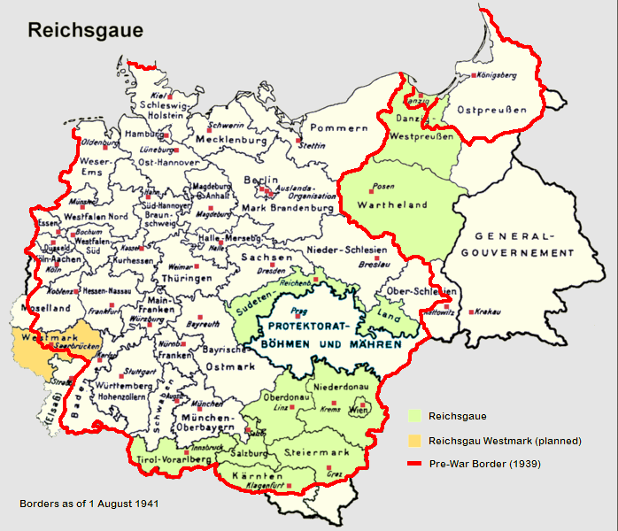
English: Reichsgaue and Generalgouvernement in June 1941
Deutsch: Reichsgaue und Generalgouvernement im Jahre 1941.
Français : La Pologne démembrée dans l'Europe allemande.
Polski: Aneksje III Rzeszy w czasie II wojny światowej (do sierpnia 1941), linia czerwona pokazuje przebieg granicy państwowej Rzeszy 1 września 1939 (wyodrębnione również Wolne Miasto Gdańsk). Aneksje terytorialne III Rzeszy do sierpnia 1941,linia czerwona - przebieg granicy państwowej Niemiec 1 września 1939. Wyodrębniony teren Generalnego Gubernatorstwa. III Rzesza oraz terytoria anektowane i Generalne Gubernatorstwo w sierpniu 1941, linia czerwona pokazuje przebieg granicy Niemiec 1 września 1939. Aneksje III Rzeszy w czasie II wojny światowej (do sierpnia 1941), linia czerwona pokazuje przebieg granicy państwowej Rzeszy 1 września 1939 (wyodrębnione również Wolne Miasto Gdańsk).
Italiano: Il Reichsgau e il Governatorato Generale nel 1941.
Nederlands: Reichsgaue en het Gouvernement-Generaal in 1941.
Español: Mapa de Alemania en 1941, sobre el este (derecha del mapa) el Gobierno General.
中文(简体):1941年的纳粹德国,包括帝国大区与被吞并的波兰总督府。
中文(繁體):1941年的納粹德國,包括帝國大區與被吞併的波蘭總督府。
Norsk bokmål: Kart over Reichsgau i 1941.
Čeština: Generální gouvernement na mapě Třetí říše.
Tiếng Việt: Nước Đức năm 1941, bao gồm lãnh thổ của Ba Lan bị chiếm đóng. |
| Source |
|
| Author | Morty, Mackler, Lucius1976 |
| Other versions | de:Bild:Reichsgaue.png |
Licensing[edit]

|
Permission is granted to copy, distribute and/or modify this document under the terms of the GNU Free Documentation License, Version 1.2 or any later version published by the Free Software Foundation; with no Invariant Sections, no Front-Cover Texts, and no Back-Cover Texts. A copy of the license is included in the section entitled GNU Free Documentation License. |
| This file is licensed under the Creative Commons Attribution-Share Alike 3.0 Unported license. | ||
| ||
| This licensing tag was added to this file as part of the GFDL licensing update. |
File history
Click on a date/time to view the file as it appeared at that time.
| Date/Time | Thumbnail | Dimensions | User | Comment | |
|---|---|---|---|---|---|
| current | 20:32, 9 June 2017 | | 698 × 600 (240 KB) | Hohum (talk | contribs) | Clearer colouring |
| 14:08, 25 February 2011 |  | 698 × 600 (279 KB) | Morgan Hauser (talk | contribs) | *Bohemia-Moravia was already integrated into the Third Reich before the outbreak of the war. *General fixes. | |
| 15:52, 6 September 2006 |  | 698 × 600 (274 KB) | Ernalve (talk | contribs) | Map of Germany in 1941 - Mapa de Alemania en 1941 GFDL from from [http://en.wikipedia.org/wiki/Image:Germany1941.png] Licencia GFDL, tomado de [http://en.wikipedia.org/wiki/Image:Germany1941.png]. |
You cannot overwrite this file.
File usage on Commons
The following 2 pages use this file:
File usage on other wikis
The following other wikis use this file:
- Usage on an.wikipedia.org
- Usage on ar.wikipedia.org
- Usage on ca.wikipedia.org
- Usage on cs.wikipedia.org
- Usage on de.wikipedia.org
- Usage on en.wikipedia.org
- Usage on es.wikipedia.org
- Usage on fa.wikipedia.org
- Usage on fr.wikipedia.org
- Usage on hy.wikipedia.org
- Usage on id.wikipedia.org
- Usage on it.wikipedia.org
- Usage on ja.wikipedia.org
- Usage on lt.wikipedia.org
- Usage on nl.wikipedia.org
- Usage on no.wikipedia.org
- Usage on pt.wikipedia.org
- Usage on sh.wikipedia.org
- Usage on sr.wikipedia.org
- Usage on th.wikipedia.org
- Usage on tr.wikipedia.org
- Usage on uk.wikipedia.org
- Usage on vi.wikipedia.org
- Usage on zh.wikipedia.org