File:Afghanistan politisch 2000.png
Jump to navigation
Jump to search

Size of this preview: 768 × 600 pixels. Other resolutions: 307 × 240 pixels | 615 × 480 pixels | 983 × 768 pixels | 1,280 × 1,000 pixels | 2,079 × 1,624 pixels.
Original file (2,079 × 1,624 pixels, file size: 2.99 MB, MIME type: image/png)
Captions
Captions
Add a one-line explanation of what this file represents
Summary[edit]
| Description |
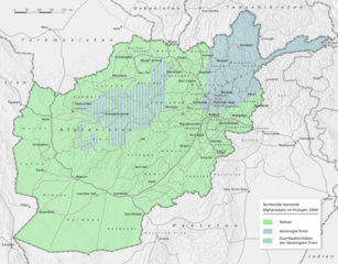
Deutsch: Vereinfachte Darstellung der territorialen Kontrolle Afghanistans im Frühjahr 2000 |
| Date | |
| Source |
Transferred from de.wikipedia to Commons by NordNordWest using CommonsHelper.
Schummerung basiert auf:
|
| Author | Benutzer:Sommerkom |
Licensing[edit]
This file is licensed under the Creative Commons Attribution-Share Alike 3.0 Germany license.
- You are free:
- to share – to copy, distribute and transmit the work
- to remix – to adapt the work
- Under the following conditions:
- attribution – You must give appropriate credit, provide a link to the license, and indicate if changes were made. You may do so in any reasonable manner, but not in any way that suggests the licensor endorses you or your use.
- share alike – If you remix, transform, or build upon the material, you must distribute your contributions under the same or compatible license as the original.

Original upload log[edit]
The original description page was here. All following user names refer to de.wikipedia.
- 2010-09-10 09:45 Sommerkom 2079×1624× (3132076 bytes) {{Information |Beschreibung = Vereinfachte Darstellung der territorialen Kontrolle Afghanistans im Frühjahr 2000 |Quelle = Territoriale Kontrolle nach: * [[Gilles Dorronsoro]]: ''Revolution Unending: Afghanistan, 1979 to the Present'', Columbia Universi
File history
Click on a date/time to view the file as it appeared at that time.
| Date/Time | Thumbnail | Dimensions | User | Comment | |
|---|---|---|---|---|---|
| current | 19:02, 6 September 2021 | | 2,079 × 1,624 (2.99 MB) | Halo FC (talk | contribs) | changed map colors |
| 18:47, 6 September 2021 |  | 2,079 × 1,624 (3.33 MB) | Halo FC (talk | contribs) | changed map colors | |
| 20:06, 16 September 2010 |  | 2,079 × 1,624 (2.99 MB) | File Upload Bot (Magnus Manske) (talk | contribs) | {{BotMoveToCommons|de.wikipedia|year={{subst:CURRENTYEAR}}|month={{subst:CURRENTMONTHNAME}}|day={{subst:CURRENTDAY}}}} {{Information |Description={{de|Vereinfachte Darstellung der territorialen Kontrolle Afghanistans im Frühjahr 2000}} |Source=Transferr |
You cannot overwrite this file.
File usage on Commons
The following page uses this file:
File usage on other wikis
The following other wikis use this file:
- Usage on ar.wikipedia.org
- Usage on ast.wikipedia.org
- Usage on az.wikipedia.org
- Usage on be.wikipedia.org
- Usage on bg.wikipedia.org
- Usage on ca.wikipedia.org
- Usage on cs.wikipedia.org
- Usage on de.wikipedia.org
- Usage on el.wikipedia.org
- Usage on en.wikipedia.org
- Usage on es.wikipedia.org
- Usage on fi.wikipedia.org
- Usage on id.wikipedia.org
- Usage on it.wikipedia.org
- Usage on ja.wikipedia.org
- Usage on km.wikipedia.org
- Usage on ko.wikipedia.org
- Usage on nl.wikipedia.org
- Usage on pnb.wikipedia.org
- Usage on ps.wikipedia.org
- Usage on pt.wikipedia.org
- Usage on ru.wikipedia.org
- Usage on sd.wikipedia.org
- Usage on sv.wikipedia.org
- Usage on tg.wikipedia.org
- Usage on tr.wikipedia.org
- Usage on ur.wikipedia.org
- Usage on uz.wikipedia.org
- Usage on vi.wikipedia.org
- Usage on www.wikidata.org