File:Roman.Wales.Forts.Fortlets.Roads.jpg
Jump to navigation
Jump to search
Size of this preview: 448 × 599 pixels. Other resolutions: 179 × 240 pixels | 359 × 480 pixels | 574 × 768 pixels | 765 × 1,024 pixels | 2,092 × 2,798 pixels.
Original file (2,092 × 2,798 pixels, file size: 856 KB, MIME type: image/jpeg)
Captions
Captions
Add a one-line explanation of what this file represents
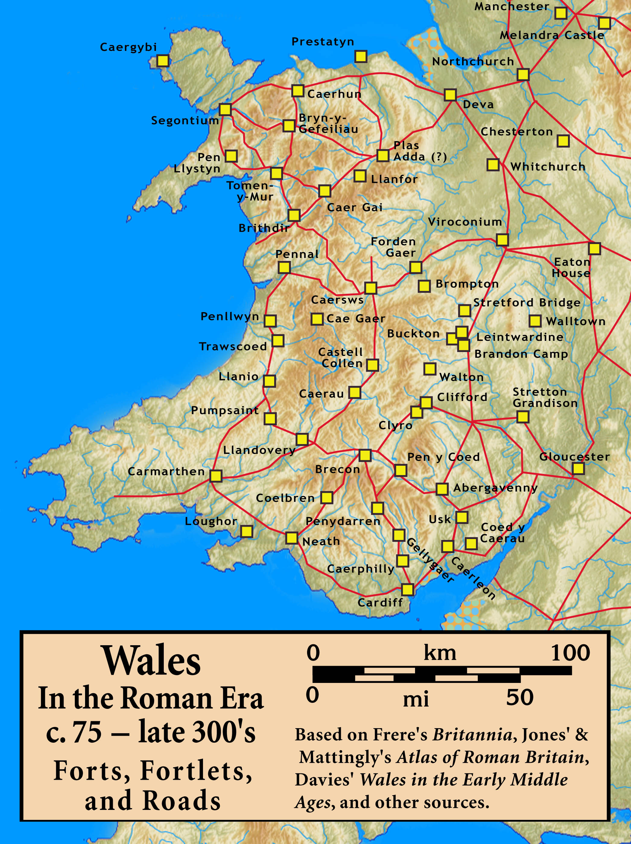
| Description | Roman Wales, c. 48 — c. 395: Military Forts, Fortlets, and Roads |
| Date | |
| Source |
Based on Frere's Britannia, Jones' & Mattingly's Atlas of Roman Britain, Davies' Wales in the Early Middle Ages, the Antonine Itinerary, and other sources (roads are incomplete; forts were built/abandoned over time) — sources are cited in the image legend |
| Author | my work |
I, the copyright holder of this work, hereby publish it under the following license:
This file is licensed under the Creative Commons Attribution-Share Alike 3.0 Unported license.
- You are free:
- to share – to copy, distribute and transmit the work
- to remix – to adapt the work
- Under the following conditions:
- attribution – You must give appropriate credit, provide a link to the license, and indicate if changes were made. You may do so in any reasonable manner, but not in any way that suggests the licensor endorses you or your use.
- share alike – If you remix, transform, or build upon the material, you must distribute your contributions under the same or compatible license as the original.
File history
Click on a date/time to view the file as it appeared at that time.
| Date/Time | Thumbnail | Dimensions | User | Comment | |
|---|---|---|---|---|---|
| current | 01:02, 20 September 2010 | | 2,092 × 2,798 (856 KB) | Notuncurious (talk | contribs) | revise the title box |
| 01:22, 16 September 2010 |  | 2,327 × 3,243 (962 KB) | Notuncurious (talk | contribs) | smaller, less obtrusive annotation | |
| 00:45, 13 September 2010 |  | 2,800 × 3,669 (987 KB) | Notuncurious (talk | contribs) | {{Information |Description= Roman Wales, c. 48 — c. 395: Military Forts, Fortlets, and Roads |Source=Based on Frere's ''Britannia'', Jones' & Mattingly's ''Atlas of Roman Britain'', Davies' ''Wales in the Early Middle Ages'', the ''Antonine Itinerar | |
| 19:36, 31 August 2010 |  | 2,031 × 2,829 (859 KB) | Notuncurious (talk | contribs) | {{Information |Description= Roman Wales, c. 48 — c. 395: Forts, Fortlets, and Roads |Source=Based on Frere's ''Britannia'', Jones' & Mattingly's ''Atlas of Roman Britain'', Davies' ''Wales in the Early Middle Ages'', the ''Antonine Itinerary'', and |
You cannot overwrite this file.
File usage on Commons
There are no pages that use this file.
File usage on other wikis
The following other wikis use this file:
- Usage on ar.wikipedia.org
- Usage on azb.wikipedia.org
- Usage on bn.wikipedia.org
- Usage on cs.wikipedia.org
- Usage on de.wikipedia.org
- Usage on en.wikipedia.org
- Usage on fa.wikipedia.org
- Usage on id.wikipedia.org
- Usage on it.wikipedia.org
- Usage on min.wikipedia.org
- Usage on ru.wikipedia.org
- Usage on sh.wikipedia.org
- Usage on sl.wikipedia.org
- Usage on sq.wikipedia.org
- Usage on sr.wikipedia.org
- Usage on sv.wikipedia.org
- Usage on test2.wikipedia.org
- Usage on wuu.wikipedia.org