File:Israel districts named.png
Jump to navigation
Jump to search

Size of this preview: 223 × 598 pixels. Other resolutions: 89 × 240 pixels | 500 × 1,341 pixels.
Original file (500 × 1,341 pixels, file size: 32 KB, MIME type: image/png)
Captions
Captions
Add a one-line explanation of what this file represents
Summary[edit]
| Description |
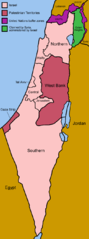
English: Map of the districts of Israel. |
| Source | Own work |
| Author | Made by User:Golbez |
| Other versions | Derivative works of this file: Israel districts named hr.svg |
This file is licensed under the Creative Commons Attribution-Share Alike 2.0 Generic license.
- You are free:
- to share – to copy, distribute and transmit the work
- to remix – to adapt the work
- Under the following conditions:
- attribution – You must give appropriate credit, provide a link to the license, and indicate if changes were made. You may do so in any reasonable manner, but not in any way that suggests the licensor endorses you or your use.
- share alike – If you remix, transform, or build upon the material, you must distribute your contributions under the same or compatible license as the original.
File history
Click on a date/time to view the file as it appeared at that time.
| Date/Time | Thumbnail | Dimensions | User | Comment | |
|---|---|---|---|---|---|
| current | 06:47, 2 July 2005 | 500 × 1,341 (32 KB) | Golbez (talk | contribs) | Map of the districts of Israel. Source: Made by User:Golbez. {{cc-by-sa-2.0}} Category:Maps of Israel\ |
You cannot overwrite this file.
File usage on Commons
The following 3 pages use this file:
File usage on other wikis
The following other wikis use this file:
- Usage on en.wikipedia.org
- Usage on he.wikipedia.org
- Usage on id.wikipedia.org
- Usage on ms.wikipedia.org
- Usage on nl.wikipedia.org
- Usage on no.wikinews.org
- Usage on sh.wikipedia.org
- Usage on sq.wikipedia.org
- Usage on sv.wikipedia.org
- Usage on yi.wikipedia.org