File:Göteborg stor karta tätort 2015 och småort 2015.png
Jump to navigation
Jump to search

Size of this preview: 520 × 600 pixels. Other resolutions: 208 × 240 pixels | 416 × 480 pixels | 666 × 768 pixels | 888 × 1,024 pixels | 1,465 × 1,689 pixels.
Original file (1,465 × 1,689 pixels, file size: 2.19 MB, MIME type: image/png)
Captions
Captions
Add a one-line explanation of what this file represents
Summary[edit]
| Description |
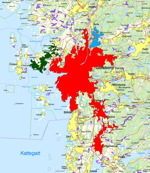
Svenska: Tätorterna Göteborg, Björlanda och Torslanda samt Gunnared och Hammarkullen med gränserna från Statistiska centralbyråns tätortsavgränsning 2015 och gränserna från småortsavgränsningen 2015 i lila. Göteborg i rött, Björlanda och Torslanda i grönt samt Gunnared och Hammarkullen i blått. Bakgrundskarta från Lantmäteriet, skala 1:120 944. |
| Date | |
| Source | Bakgrundskarta från Lantmäteriet, Öppna Geodata. Tätortsgränser från Statistiska centralbyrån, Öppna Geodata. |
| Author | Lantmäteriet och Statistiska centralbyrån. |
Licensing[edit]
This file is licensed under the Creative Commons Attribution-Share Alike 4.0 International license.
- You are free:
- to share – to copy, distribute and transmit the work
- to remix – to adapt the work
- Under the following conditions:
- attribution – You must give appropriate credit, provide a link to the license, and indicate if changes were made. You may do so in any reasonable manner, but not in any way that suggests the licensor endorses you or your use.
- share alike – If you remix, transform, or build upon the material, you must distribute your contributions under the same or compatible license as the original.
File history
Click on a date/time to view the file as it appeared at that time.
| Date/Time | Thumbnail | Dimensions | User | Comment | |
|---|---|---|---|---|---|
| current | 13:47, 29 December 2016 | | 1,465 × 1,689 (2.19 MB) | Portunes (talk | contribs) | User created page with UploadWizard |
You cannot overwrite this file.
File usage on Commons
There are no pages that use this file.
File usage on other wikis
The following other wikis use this file:
- Usage on fi.wikipedia.org
- Usage on sv.wikipedia.org