File:Europe.jpg
Jump to navigation
Jump to search

Size of this preview: 680 × 600 pixels. Other resolutions: 272 × 240 pixels | 544 × 480 pixels | 871 × 768 pixels | 1,219 × 1,075 pixels.
Original file (1,219 × 1,075 pixels, file size: 638 KB, MIME type: image/jpeg)
Captions
Captions
Add a one-line explanation of what this file represents
Summary[edit]
| Description |
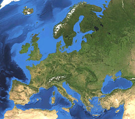
English: Satellite picture of Europe. Land terrain and bathymetry (ocean-floor topography). |
| Date | |
| Source | Own work by uploader, made with NASA World Wind. |
| Author | Koyos |
| Other versions |
|


Licensing[edit]
| I, the copyright holder of this work, release this work into the public domain. This applies worldwide. In some countries this may not be legally possible; if so: I grant anyone the right to use this work for any purpose, without any conditions, unless such conditions are required by law. |
File history
Click on a date/time to view the file as it appeared at that time.
| Date/Time | Thumbnail | Dimensions | User | Comment | |
|---|---|---|---|---|---|
| current | 15:47, 7 February 2009 | | 1,219 × 1,075 (638 KB) | Koyos (talk | contribs) | {{Information |Description={{en|1=Satellite picture of Europe. Terrain and ocean topography.}} |Source=Own work by uploader, made with NASA World Wind. |Author=Koyos |Date= |Permission= |other_versions= }} <!--{{ImageUpload|full}}--> [[Cat |
You cannot overwrite this file.
File usage on Commons
More than 100 pages use this file. The following list shows the first 100 pages that use this file only. A full list is available.
- Atlas of Europe
- Чорне море - Чёрное море - Karadeniz - Marea Neagră
- User:Koyos
- File:Africa satellite.jpg
- File:America sattelite.jpg
- File:Antarctica satellite.jpg
- File:Asia satellite.jpg
- File:Europe.jpg
- File:North America satellite.jpg
- File:Oceania satellite map.jpg
- File:South America satellite.jpg
- Template:Europeeventyear
- Category:1910 events in Europe
- Category:1911 events in Europe
- Category:1912 events in Europe
- Category:1913 events in Europe
- Category:1914 events in Europe
- Category:1915 events in Europe
- Category:1920 events in Europe
- Category:1921 events in Europe
- Category:1922 events in Europe
- Category:1923 events in Europe
- Category:1924 events in Europe
- Category:1925 events in Europe
- Category:1927 events in Europe
- Category:1928 events in Europe
- Category:1929 events in Europe
- Category:1930 events in Europe
- Category:1931 events in Europe
- Category:1932 events in Europe
- Category:1933 events in Europe
- Category:1934 events in Europe
- Category:1935 events in Europe
- Category:1936 events in Europe
- Category:1937 events in Europe
- Category:1938 events in Europe
- Category:1939 events in Europe
- Category:1945 events in Europe
- Category:1946 events in Europe
- Category:1948 events in Europe
- Category:1949 events in Europe
- Category:1950 events in Europe
- Category:1952 events in Europe
- Category:1953 events in Europe
- Category:1954 events in Europe
- Category:1955 events in Europe
- Category:1956 events in Europe
- Category:1957 events in Europe
- Category:1958 events in Europe
- Category:1959 events in Europe
- Category:1960 events in Europe
- Category:1961 events in Europe
- Category:1962 events in Europe
- Category:1963 events in Europe
- Category:1964 events in Europe
- Category:1965 events in Europe
- Category:1966 events in Europe
- Category:1967 events in Europe
- Category:1968 events in Europe
- Category:1969 events in Europe
- Category:1970 events in Europe
- Category:1971 events in Europe
- Category:1972 events in Europe
- Category:1973 events in Europe
- Category:1974 events in Europe
- Category:1975 events in Europe
- Category:1978 events in Europe
- Category:1979 events in Europe
- Category:1980 events in Europe
- Category:1981 events in Europe
- Category:1982 events in Europe
- Category:1983 events in Europe
- Category:1984 events in Europe
- Category:1985 events in Europe
- Category:1986 events in Europe
- Category:1987 events in Europe
- Category:1988 events in Europe
- Category:1989 events in Europe
- Category:1990 events in Europe
- Category:1991 events in Europe
- Category:1992 events in Europe
- Category:1993 events in Europe
- Category:1994 events in Europe
- Category:1995 events in Europe
- Category:1996 events in Europe
- Category:1997 events in Europe
- Category:1998 events in Europe
- Category:1999 events in Europe
- Category:2000 events in Europe
- Category:2001 events in Europe
- Category:2002 events in Europe
- Category:2003 events in Europe
- Category:2004 events in Europe
- Category:2005 events in Europe
- Category:2005 floods in Europe
- Category:2006 events in Europe
- Category:2007 events in Europe
- Category:2008 events in Europe
- Category:2009 events in Europe
- Category:2010 events in Europe
View more links to this file.
File usage on other wikis
The following other wikis use this file:
- Usage on be.wikipedia.org
- Удзельнік:Никита Курепин
- Удзельнік:LKS
- Удзельнік:Sir Ksandr
- Удзельнік:Чаховіч Уладзіслаў
- Удзельнік:J-ka Zadzvinski
- Удзельнік:Zemant
- Удзельнік:Mazta
- Удзельнік:Бычкоў Мікіта
- Удзельнік:Dostojewskij
- Удзельнік:Kossa b
- Удзельнік:Илья Драконов
- Удзельнік:Aliaksandr y
- Удзельнік:Петр дракона 78
- Удзельнік:Ілля Банцэвіч
- Удзельнік:BY Alex Sander
- Удзельнік:Belarusian volunteer
- Usage on ceb.wikipedia.org
- Usage on cs.wikipedia.org
- Usage on de.wikipedia.org
- Usage on en.wikipedia.org
- Usage on es.wikipedia.org
- Usage on fi.wikipedia.org
- Usage on gn.wikipedia.org
- Usage on id.wikipedia.org
- Usage on id.wiktionary.org
- Usage on ie.wikipedia.org
- Usage on incubator.wikimedia.org
- Usage on it.wikibooks.org
- Usage on kk.wikipedia.org
- Usage on pl.wikibooks.org
- Usage on pt.wikipedia.org
- Usage on sv.wikipedia.org
View more global usage of this file.