File:EU1952-1973.svg
Jump to navigation
Jump to search

Size of this PNG preview of this SVG file: 600 × 600 pixels. Other resolutions: 240 × 240 pixels | 480 × 480 pixels | 768 × 768 pixels | 1,024 × 1,024 pixels | 2,048 × 2,048 pixels | 610 × 610 pixels.
Original file (SVG file, nominally 610 × 610 pixels, file size: 425 KB)
Captions
Captions
Add a one-line explanation of what this file represents
Summary[edit]
| Description |
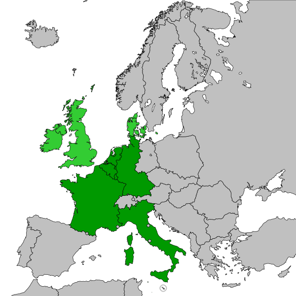
English: Enlargement 1973:
European Economic Community before the enlargement 1973
Enlargement 1973 Svenska: Utvidgningen 1973:
Europeiska ekonomiska gemenskapen innan utvidgningen 1973
Utvidgningen 1973 |
| Date | |
| Source | Europe-countries-outline-iso-coded-plain.svg |
| Author | Original map created by Mfloryan, modified by Nablicus |
| SVG development |
Licensing[edit]
This file is licensed under the Creative Commons Attribution-Share Alike 4.0 International license.
- You are free:
- to share – to copy, distribute and transmit the work
- to remix – to adapt the work
- Under the following conditions:
- attribution – You must give appropriate credit, provide a link to the license, and indicate if changes were made. You may do so in any reasonable manner, but not in any way that suggests the licensor endorses you or your use.
- share alike – If you remix, transform, or build upon the material, you must distribute your contributions under the same or compatible license as the original.
File history
Click on a date/time to view the file as it appeared at that time.
| Date/Time | Thumbnail | Dimensions | User | Comment | |
|---|---|---|---|---|---|
| current | 20:16, 22 April 2020 | | 610 × 610 (425 KB) | Nablicus (talk | contribs) | new version |
| 16:06, 10 April 2020 |  | 610 × 610 (428 KB) | Nablicus (talk | contribs) | minor adjustments | |
| 11:19, 3 January 2018 |  | 610 × 610 (341 KB) | Nablicus (talk | contribs) | new version | |
| 21:49, 11 December 2010 |  | 645 × 690 (541 KB) | Nablicus (talk | contribs) | new colors | |
| 22:09, 19 July 2009 |  | 645 × 690 (541 KB) | Nablicus (talk | contribs) | new version | |
| 12:45, 17 November 2008 |  | 645 × 690 (538 KB) | Nablicus (talk | contribs) | better colors | |
| 17:01, 17 February 2008 |  | 645 × 690 (538 KB) | Nablicus (talk | contribs) | Kosovo | |
| 12:44, 27 October 2007 |  | 645 × 690 (535 KB) | Nablicus (talk | contribs) | == Beskrivning == {{Information |Description=Map of the European Union (1952-1973) |Source=Image:EU1952-1973.PNG |Date=2007-10-27 |Author=glentamara |Permission= |other_versions= }} Category:Maps of the European Union enlargement |
You cannot overwrite this file.
File usage on Commons
The following 2 pages use this file:
File usage on other wikis
The following other wikis use this file:
- Usage on sv.wikipedia.org