File:Chquel-map-fr.png
Jump to navigation
Jump to search
No higher resolution available.
Chquel-map-fr.png (348 × 352 pixels, file size: 145 KB, MIME type: image/png)
Captions
Captions
Add a one-line explanation of what this file represents
Summary[edit]
| Camera location | | View this and other nearby images on: OpenStreetMap |
|---|
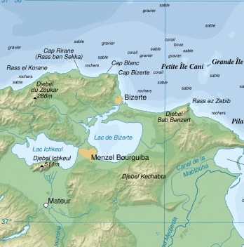
| Description | Topographic map in French of the Gulf of Tunis, Tunisia, with indication of the nature of the sea bottom |
| Date | |
| Source |
Own work ; Topographic map : NASA Shuttle Radar Topography Mission (SRTM3 v.2) (public domain) edited with dlgv32 Pro and vectorized with Inkscape ; UTM projection ; WGS84 datum ; shaded relief (composite image of N-W, W and N lightning positions) ; References used for bathymetry and additional data : * 1:250,000 U.S. Army maps (printed 1956) ; * Google Earth ; * Locator map : Image:Tunisia.svg (modified) created by Philip Ronan (in PD) Approximate scale of topographic data and shore / lakes limits : 1:372,000 ; Note : The shaded relief is a raster image embedded in the SVG file which increases its size. If you want a lighter map for other purposes, delete the shaded relief image in your file. |
| Author | Eric Gaba (Sting) |
| Permission (Reusing this file) |
Attribution and Share-Alike required |
base source: http://commons.wikimedia.org/wiki/Image:Tunis_Gulf_topo_map-fr.svg
Français : * Sujet : Carte topographique en français du Golfe de Tunis, avec indication de la nature des fonds marins ;
- Sources : Création personnelle
- Données topographiques : NASA Shuttle Radar Topography Mission (SRTM3 v.2) (domaine public) édité avec dlgv32 Pro et vectorisé avec Inkscape ; projection UTM ; WGS84 datum ; relief ombré (image composite d'éclairages du N-O, O et N) ;
- Références utilisées pour la bathymétrie et les données complémentaires :
- Cartes au 1:250 000e de l'U.S. Army (imprimées en 1956) ;
- Google Earth ;
- Carte de localisation : Image:Tunisia.svg (modifiée) créée par Philip Ronan dans le domaine public ;
- Échelle approximative : 1:372 000 (données topographiques et tracés des côtes / lacs) ;
- Note : Le relief ombré est une image bitmap encapsulée dans le fichier SVG qui augmente son poids. Si vous avez besoin d'une carte plus légère pour d'autres utilisations, supprimez l'image du relief ombré dans votre fichier ;
- Auteur : Eric Gaba (fr:Sting) ;
- Date : Octobre 2007.
Licensing[edit]
I, the copyright holder of this work, hereby publish it under the following licenses:

|
Permission is granted to copy, distribute and/or modify this document under the terms of the GNU Free Documentation License, Version 1.2 or any later version published by the Free Software Foundation; with no Invariant Sections, no Front-Cover Texts, and no Back-Cover Texts. A copy of the license is included in the section entitled GNU Free Documentation License. |
This file is licensed under the Creative Commons Attribution-Share Alike 3.0 Unported, 2.5 Generic, 2.0 Generic and 1.0 Generic license.
- You are free:
- to share – to copy, distribute and transmit the work
- to remix – to adapt the work
- Under the following conditions:
- attribution – You must give appropriate credit, provide a link to the license, and indicate if changes were made. You may do so in any reasonable manner, but not in any way that suggests the licensor endorses you or your use.
- share alike – If you remix, transform, or build upon the material, you must distribute your contributions under the same or compatible license as the original.
You may select the license of your choice.
File history
Click on a date/time to view the file as it appeared at that time.
| Date/Time | Thumbnail | Dimensions | User | Comment | |
|---|---|---|---|---|---|
| current | 00:18, 17 July 2008 | | 348 × 352 (145 KB) | Ori~ (talk | contribs) | {{Information |Description= |Source= |Date= |Author= |Permission= |other_versions= }} |
| 00:16, 17 July 2008 |  | 849 × 768 (699 KB) | Ori~ (talk | contribs) | base source: http://commons.wikimedia.org/wiki/Image:Tunis_Gulf_topo_map-fr.svg == Summary == {{Location|37|00|00|N|10|30|00|E|scale:500000}} {{Information |Description=Topographic map in French of the Gulf of Tunis, Tunisia, with i |
You cannot overwrite this file.
File usage on Commons
There are no pages that use this file.
File usage on other wikis
The following other wikis use this file:
- Usage on et.wikipedia.org
- Usage on he.wikipedia.org
- Usage on lv.wikipedia.org
- Usage on sv.wikipedia.org