File:Bg-map.png
Jump to navigation
Jump to search
No higher resolution available.
Bg-map.png (325 × 348 pixels, file size: 16 KB, MIME type: image/png)
Captions
Captions
Add a one-line explanation of what this file represents
Summary[edit]
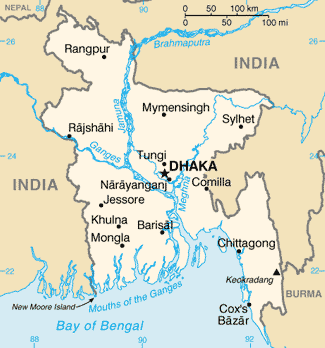
| Description |
Azərbaycanca: Bangladeşin xəritəsi
Bislama: Map blong Bangladesh
বাংলা: বাংলাদেশের মানচিত্র
Esperanto: Mapo de Bangladeŝo
Español: Mapa de Bangladesh |
| Date | |
| Source |
CIA World Factbook |
| Author | United States Central Intelligence Agency |
| Other versions |
|
Licensing[edit]
This image is in the public domain because it contains materials that originally came from the United States Central Intelligence Agency's World Factbook.
|
 |
Derivative works[edit]


File history
Click on a date/time to view the file as it appeared at that time.
| Date/Time | Thumbnail | Dimensions | User | Comment | |
|---|---|---|---|---|---|
| current | 18:39, 12 March 2022 | | 325 × 348 (16 KB) | Lojwe (talk | contribs) | Cropped 2 % horizontally, 2 % vertically using CropTool with precise mode. |
| 22:38, 26 February 2005 |  | 330 × 354 (16 KB) | Alfio (talk | contribs) | CIA map of Bangladesh |
You cannot overwrite this file.
File usage on Commons
The following 4 pages use this file:
- Atlas of Bangladesh
- Maps of Bangladesh
- বাংলাদেশ
- File:Bangladesh-CIA WFB Map.png (file redirect)
File usage on other wikis
The following other wikis use this file:
- Usage on ar.wikipedia.org
- Usage on as.wikipedia.org
- Usage on az.wikipedia.org
- Usage on ban.wikipedia.org
- Usage on ba.wikipedia.org
- Usage on bg.wikipedia.org
- Usage on bg.wiktionary.org
- Usage on bn.wikipedia.org
- Usage on bn.wiktionary.org
- Usage on ca.wikipedia.org
- Usage on ce.wikipedia.org
- Usage on cv.wikipedia.org
- Usage on da.wikipedia.org
- Usage on de.wikipedia.org
- Usage on de.wikinews.org
- Usage on de.wiktionary.org
- Usage on dsb.wikipedia.org
- Usage on el.wikipedia.org
- Usage on en.wikipedia.org
View more global usage of this file.