File:Alps location map.png
Jump to navigation
Jump to search

Size of this preview: 800 × 552 pixels. Other resolutions: 320 × 221 pixels | 640 × 442 pixels | 1,024 × 707 pixels | 1,280 × 884 pixels | 2,000 × 1,381 pixels.
Original file (2,000 × 1,381 pixels, file size: 4.73 MB, MIME type: image/png)
Captions
Captions
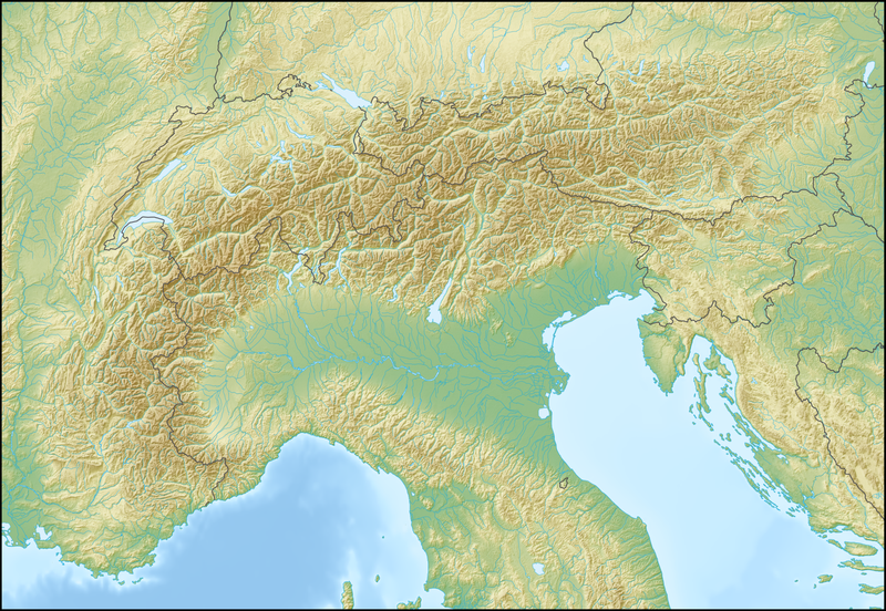
Location map of the Alps
.png)
.png)
.png)
.png)
.png)
.png)
.png)
.png)
.png)
.png)
.png)
.png)
.png)
.png)
.png)
.png)
.png)
.png)
.png)
.png)
.png)
.png)
.png)
.png)
.png)
.png)
.png)
.png)
.png)
.png)
.png)
.png)
.png)
.png)
.png)
.png)
.png)
.png)
.png)
.png)
.png)

|
This map has been made or improved in the German Kartenwerkstatt (Map Lab). You can propose maps to improve as well.
|
Licensing[edit]
The map has been created with the Generic Mapping Tools: https://www.generic-mapping-tools.org/ using one or more of these public-domain datasets for the relief:
|

|
Permission is granted to copy, distribute and/or modify this document under the terms of the GNU Free Documentation License, Version 1.2 or any later version published by the Free Software Foundation; with no Invariant Sections, no Front-Cover Texts, and no Back-Cover Texts. A copy of the license is included in the section entitled GNU Free Documentation License. |
| This file is licensed under the Creative Commons Attribution-Share Alike 3.0 Unported license. | ||
| ||
| This licensing tag was added to this file as part of the GFDL licensing update. |
File history
Click on a date/time to view the file as it appeared at that time.
| Date/Time | Thumbnail | Dimensions | User | Comment | |
|---|---|---|---|---|---|
| current | 12:58, 20 February 2009 | | 2,000 × 1,381 (4.73 MB) | Lencer (talk | contribs) | {{Information |Description= {{de|Positionskarte der Alpen}} Quadratische Plattkarte. Geographische Begrenzung der Karte: * N: 48.5 ° N * S: 42.75 ° N * W: 4.5 ° O * O: 17 ° O {{en|Location map of the Alps}} Equirecta |
You cannot overwrite this file.
File usage on Commons
The following 49 pages use this file:
- Commons:Files used on RegiowikiAT/2
- File:AVE Ostalpen.png
- File:Alps location map (Alpes de Provence, SOIUSA).png
- File:Alps location map (Alpes de Savoie, PWN).png
- File:Alps location map (Alpi Graie, PWN).png
- File:Alps location map (Alpi Graie, SOIUSA).png
- File:Alps location map (Bergell, AVE).png
- File:Alps location map (Berner Alpen i.w.S., SOIUSA).png
- File:Alps location map (Bernina-Alpen, AVE).png
- File:Alps location map (Berninagruppe, AVE).png
- File:Alps location map (Dachstein-Gosaukamm).png
- File:Alps location map (Dachsteingebirge).png
- File:Alps location map (Dolomiti, AVE).png
- File:Alps location map (Ennstaler Alpen, AVE).png
- File:Alps location map (Gailtaler Alpen).png
- File:Alps location map (Gruppo Sobretta-Gavia, AVE).png
- File:Alps location map (Julijske Alpe).png
- File:Alps location map (Karnischer Hauptkamm, AVE).png
- File:Alps location map (Livigno-Alpen, AVE).png
- File:Alps location map (Prealpi Carniche, AVE).png
- File:Alps location map (Prealpi Carniche & Karnischer Hauptkamm).png
- File:Alps location map (Prealpi Gardesane, AVE).png
- File:Alps location map (Préalpes de Provence).png
- File:Alps location map (Puez-Geisler-Gruppe, AVE).png
- File:Alps location map (Salzburger Kalkalpen, PWN).png
- File:Alps location map (Salzburger Schieferalpen, AVE).png
- File:Alps location map (Schobergruppe).png
- File:Alps location map (Stubaier Alpen).png
- File:Alps location map (Tennengebirge).png
- File:Alps location map (Totes Gebirge, AVE).png
- File:Alps location map (Venedigergruppe, AVE).png
- File:Alps location map (Zillertaler Alpen, AVE).png
- File:Alps location map borders.png
- File:Alps location map borders cities.png
- File:Alps locator map (Alpi Lepontini).png
- File:Alps locator map (Appenzeller Alpen).png
- File:Alps locator map (Berner Alpen).png
- File:Alps locator map (Emmentaler Alpen).png
- File:Alps locator map (Glarner Alpen).png
- File:Alps locator map (Karawanken, Bachergebirge, AVE).png
- File:Alps locator map (Rätikon).png
- File:Alps locator map (Schwyzer Alpen).png
- File:Alps locator map (Urner Alpen).png
- File:Alps locator map (Walliser Alpen).png
- File:Alps locator map (Ötztaler Alpen).png
- File:Map of Alpine Glaciations.png
- File:Piz Linard location mockup 1.png
- File:Piz Linard location mockup 2.png
- File:Red Bull X-Alps 2009 - Jul28 19pm.png
File usage on other wikis
The following other wikis use this file:
- Usage on als.wikipedia.org
- Usage on an.wikipedia.org
- Usage on ar.wikipedia.org
- Usage on as.wikipedia.org
- Usage on az.wikipedia.org
- Usage on ba.wikipedia.org
- Usage on be.wikipedia.org
- Манблан
- Матэргорн
- Шаблон:На карце/Альпы
- Цугшпіцэ
- Грайскія Альпы
- Штахлеркопф
- Заходнія Альпы
- Лігурыйскія Альпы
- Бернскія Альпы
- Праванскія Альпы
- Алечгорн
- Мёнх
- Коцкія Альпы
- Альпы Дафінэ
- Лепанцінскія Альпы
- Высокі Таўэрн
- Гларнскія Альпы
- Юлійскія Альпы
- Юра (горы)
- Граўшпіц
- Рэтыйскія Альпы
- Паўднёвыя Вапняковыя Альпы
- Цэнтральныя Усходнія Альпы
- Лага-Маджорэ
- Адамела
- Берніна (горны масіў)
- Пунта-Перукеці
- Руая (рака)
- Usage on bg.wikipedia.org
View more global usage of this file.