File:AncientGreekDialects (Woodard) mk.svg
Original file (SVG file, nominally 660 × 555 pixels, file size: 1 MB)
Captions
Captions
Summary[edit]
| DescriptionAncientGreekDialects (Woodard) mk.svg |
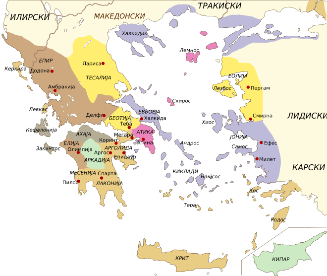
Македонски: Географска распределба на дијалектите на старогрчкиот јазик, во класичниот период. Не се прикажани: дијалектите на западните колонии Голема Грција. Картата е прецртана по изворна карта во: Roger D. Woodard (2008), "Greek dialects", во: The Ancient Languages of Europe, уредн. Roger D. Woodard, Cambridge: Cambridge University Press, стр. 51. (= делумна реиздадена верзија на The Cambridge Encyclopedia of Ancient Languages, 2004)
English: Geographical distribution of the dialects of ancient Greek, in the classical era. Not shown: dialects of the western colonies of Magna Graecia. Map re-drawn after a source map in: Roger D. Woodard (2008), "Greek dialects", in: The Ancient Languages of Europe, ed. Roger D. Woodard, Cambridge: Cambridge University Press, p.51. (= partial re-published version of The Cambridge Encyclopedia of Ancient Languages, 2004) |
| Date | 14 December 2008; (original: 6 September 2008) |
| Source | File:AncientGreekDialects (Woodard).svg Data after Woodard (2008), see below. Base map Image:Greece map blank.svg (public domain) |
| Author | B. Jankuloski (translator). Original by Fut.Perf. |
| Other versions |
[edit] Maps following Woodward 2008[edit]Based on: Roger D. Woodard, "Greek dialects", in The Ancient Languages of Europe, ed. Roger D. Woodard, Cambridge: Cambridge University Press, 2008, p. 50. (= partial re-published version of The Cambridge Encyclopedia of Ancient Languages, 2004).
Maps following Horrocks 2006[edit]Based on: G. Horrocks, Ελληνικά: Ιστορία της γλώσσας και των ομιλητών της, Athens, 2006, p. 71 (in turn after J. M. Hall, "The role of language in Greek ethnicities". Proceedings of the Cambridge Philological Society 41 (1995), 83-100).
Based on Horrocks, with original data (Athenian colonies and coasts in 400 BC):
|
Licensing[edit]
| Public domainPublic domainfalsefalse |
| I, the copyright holder of this work, release this work into the public domain. This applies worldwide. In some countries this may not be legally possible; if so: I grant anyone the right to use this work for any purpose, without any conditions, unless such conditions are required by law. |
File history
Click on a date/time to view the file as it appeared at that time.
| Date/Time | Thumbnail | Dimensions | User | Comment | |
|---|---|---|---|---|---|
| current | 03:38, 14 December 2008 | 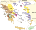 | 660 × 555 (1 MB) | Bjankuloski06en (talk | contribs) | == Summary == {{Information |Description={{mk|1=Географска распределба на дијалектите на старогрчкиот јазик, во класичниот |
You cannot overwrite this file.
File usage on Commons
The following 32 pages use this file:
- File:AncientGreekDialects (Woodard)-hu.svg
- File:AncientGreekDialects (Woodard)-mk.svg (file redirect)
- File:AncientGreekDialects (Woodard)-pl.svg
- File:AncientGreekDialects (Woodard) cs.svg
- File:AncientGreekDialects (Woodard) de.svg
- File:AncientGreekDialects (Woodard) en.svg
- File:AncientGreekDialects (Woodard) fr.svg
- File:AncientGreekDialects (Woodard) grc.svg
- File:AncientGreekDialects (Woodard) hr.svg
- File:AncientGreekDialects (Woodard) id.svg
- File:AncientGreekDialects (Woodard) it.svg
- File:AncientGreekDialects (Woodard) la.svg
- File:AncientGreekDialects (Woodard) mk.svg
- File:AncientGreekDialects (Woodard) pt.svg
- File:AncientGreekDialects (Woodard) ru.svg
- File:AncientGreekDialects (Woodard) zh.svg
- File:Ancient greek dialects-en.svg
- File:Ancient greek dialects-fr-400.jpg
- File:Ancient greek dialects-fr.svg
- File:Ancient greek dialects-grc.svg
- File:Ancient greek dialects-no.svg
- File:Ancient greek dialects (-400)-es.svg
- File:Ancient greek dialects (-400)-fr.svg
- File:Magna Graecia ancient colonies and dialects-de.svg
- File:Magna Graecia ancient colonies and dialects-el.svg
- File:Magna Graecia ancient colonies and dialects-es.svg
- File:Magna Graecia ancient colonies and dialects-eu.svg
- File:Magna Graecia ancient colonies and dialects-fr.svg
- File:Magna Graecia ancient colonies and dialects-id.svg
- File:Magna Graecia ancient colonies and dialects-pt.svg
- File:Magna Graecia ancient colonies and dialects-zh.svg
- Template:Other versions/Map Ancient Greek dialects
File usage on other wikis
The following other wikis use this file:
- Usage on bg.wikipedia.org
- Usage on mk.wikipedia.org
- Usage on sr.wikipedia.org
Metadata
This file contains additional information such as Exif metadata which may have been added by the digital camera, scanner, or software program used to create or digitize it. If the file has been modified from its original state, some details such as the timestamp may not fully reflect those of the original file. The timestamp is only as accurate as the clock in the camera, and it may be completely wrong.
| Width | 659.85559 |
|---|---|
| Height | 554.9375 |


