File:Justinian555AD.png
Jump to navigation
Jump to search
Size of this preview: 800 × 434 pixels. Other resolutions: 320 × 173 pixels | 640 × 347 pixels | 1,024 × 555 pixels | 1,280 × 694 pixels | 2,111 × 1,144 pixels.
Original file (2,111 × 1,144 pixels, file size: 198 KB, MIME type: image/png)
Captions
Captions
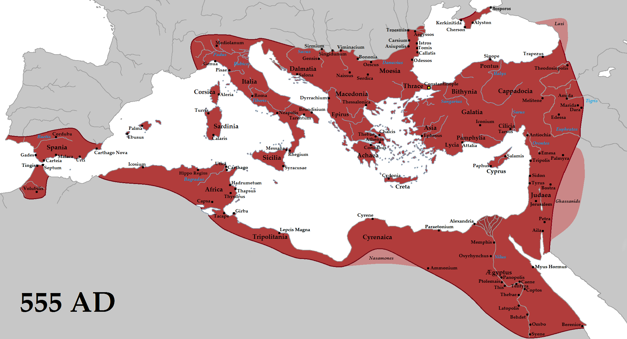
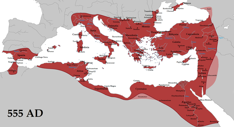
Byzantine Empire 555 AD

|
This historical map image could be re-created using vector graphics as an SVG file. This has several advantages; see Commons:Media for cleanup for more information. If an SVG form of this image is available, please upload it and afterwards replace this template with
{{vector version available|new image name}}.
It is recommended to name the SVG file “Justinian555AD.svg”—then the template Vector version available (or Vva) does not need the new image name parameter. |
Summary[edit]
| Description |
English: The Eastern Roman Empire (red) and its vassals (pink) in 555 AD during the reign of Justinian I. |
| Date | |
| Source | Own work |
| Author | Tataryn |
| Other versions | Arabic |
Licensing[edit]
I, the copyright holder of this work, hereby publish it under the following license:
This file is licensed under the Creative Commons Attribution-Share Alike 3.0 Unported license.
- You are free:
- to share – to copy, distribute and transmit the work
- to remix – to adapt the work
- Under the following conditions:
- attribution – You must give appropriate credit, provide a link to the license, and indicate if changes were made. You may do so in any reasonable manner, but not in any way that suggests the licensor endorses you or your use.
- share alike – If you remix, transform, or build upon the material, you must distribute your contributions under the same or compatible license as the original.
File history
Click on a date/time to view the file as it appeared at that time.
| Date/Time | Thumbnail | Dimensions | User | Comment | |
|---|---|---|---|---|---|
| current | 22:27, 11 March 2021 | | 2,111 × 1,144 (198 KB) | Gamerknowitall (talk | contribs) | Added the city of Bosporos. |
| 07:10, 10 February 2017 |  | 2,111 × 1,144 (216 KB) | Tataryn (talk | contribs) | Added Crimea area, more cities, fixed errors | |
| 01:36, 3 October 2015 |  | 2,111 × 1,144 (195 KB) | Tataryn (talk | contribs) | Added river labels | |
| 01:28, 3 October 2015 |  | 2,111 × 1,144 (191 KB) | Tataryn (talk | contribs) | Removed extra label | |
| 04:40, 25 September 2015 |  | 2,111 × 1,144 (192 KB) | Tataryn (talk | contribs) | Fixed eastern frontier, added cities | |
| 19:22, 10 June 2015 |  | 2,111 × 1,144 (146 KB) | Tataryn (talk | contribs) | cropped right side | |
| 19:16, 10 June 2015 |  | 2,260 × 1,144 (149 KB) | Tataryn (talk | contribs) | Added vassals | |
| 19:06, 10 June 2015 |  | 2,260 × 1,144 (147 KB) | Tataryn (talk | contribs) | Better quality, with cities | |
| 16:06, 10 August 2012 |  | 694 × 396 (13 KB) | DIREKTOR (talk | contribs) | Further | |
| 16:02, 10 August 2012 |  | 694 × 396 (13 KB) | DIREKTOR (talk | contribs) | Tyrian purple |
You cannot overwrite this file.
File usage on Commons
The following 3 pages use this file:
File usage on other wikis
The following other wikis use this file:
- Usage on af.wikipedia.org
- Usage on am.wikipedia.org
- Usage on ary.wikipedia.org
- Usage on ast.wikipedia.org
- Usage on azb.wikipedia.org
- Usage on az.wikipedia.org
- Usage on bcl.wikipedia.org
- Usage on be.wikipedia.org
- Usage on bg.wikipedia.org
- Usage on bxr.wikipedia.org
- Usage on ca.wikipedia.org
- Usage on co.wikipedia.org
- Usage on cs.wikipedia.org
- Usage on cy.wikipedia.org
- Usage on da.wikipedia.org
- Usage on de.wikipedia.org
- Usage on el.wikipedia.org
- Usage on en.wikipedia.org
- Algeria
- Empire
- Malta
- Outline of ancient Rome
- Talk:Tang dynasty
- Southern Europe
- Ipsus
- Chronology of warfare between the Romans and Germanic peoples
- Perateia
- Garius
- Portal:Turkey
- Anaua
- Komnina, Kozani
- Epiphania (Cilicia)
- Roman–Iranian relations
- Ibora
- Mossyna
- Hieria
- Harbour of Eleutherios
- Parlais
- Docimium
View more global usage of this file.